Home > Historic Landscape Characterisation > Upland Ceredigion > |

 HEOLFRYN & DOLBEUDIAU
GRID REFERENCE: SN 723660
AREA IN HECTARES: 325.8
Historic Background
In the Medieval Period this area lay within Strata Florida Abbey’s Pennardd Grange (Williams 1990, 56). Upon the Dissolution abbey lands were granted to the Earl of Essex, and subsequently in 1630 the Crosswood estate purchased most of them. The historical processes behind the development of the field system in this area are well documented. It would seem that until the 18th century much of the land in this area was open, as two late 18th century estate maps (NLW Crosswood Vol 1, 6, 8) show it as a mixture of open land and very large enclosures, with small closes or paddocks around the farmsteads of Dolbeudiau, Brynhope and Dolyrychain. By the tithe survey of 1845 (Caron Tithe Map and Apportionment) the regular field system that is present today had been established. The origin of the settlement pattern of dispersed farms is more problematic. It may well have originated in the late Medieval Period when Pennardd Grange, in common with other granges of Strata Florida, was divided into farms that were leased out on a commercial basis.
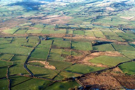
Description and essential historic landscape components
This area consists of a block of gently undulating ground, including low craggy ridges, ranging in height from 170m to 220m located to the south and west of Pontrhydfendigiad. Much of the higher ground is improved pasture, but there are considerable tracts of rough pasture and rushy ground at lower levels. Peat deposits are present in some hollows. The field system here is one of regular, small- to medium-sized fields. Boundaries are straight and consist of low earth banks topped with wire fences. Some hedges are present on the banks, but are generally in a derelict condition except in the northern part of the area and close to farmsteads where they are still stock-proof. Boundaries on low-lying ground in hollows consist of drainage ditches.
There are a couple of small farms with stone-built houses in the typical mid-to-late 19th century Georgian vernacular style of the region. Other than these, buildings consist of a small group of extensively modernised dwellings and modern houses, a caravan park and a Sunday School.
Apart from the above buildings and two minor metal mines, the recorded archaeology provides a time-depth element to the landscape in the form of an Iron Age hillfort, and a rectangular earthwork enclosure that may be of Roman date.
Apart from where it joins the village of Pontrhydfendigiad, the borders of this area are not particularly well defined, merging on all sides with the irregular field systems of neighbouring areas.
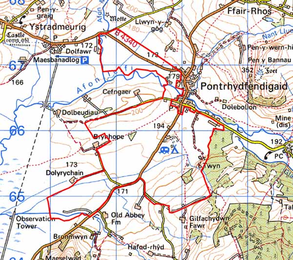
Base map reproduced from the OS map with the permission
of Ordnance Survey on behalf of The Controller of Her Majesty's Stationery
Office, © Crown Copyright 2001.
All rights reserved. Unauthorised reproduction infringes Crown Copyright
and may lead to prosecution or civil proceedings. Licence Number: GD272221