Home > Historic Landscape Characterisation > Upland Ceredigion > |

 GEUFRON - HENDRE-FELEN
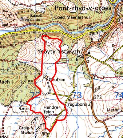
GRID REFERENCE: SN 722707
AREA IN HECTARES: 96.4
Historic Background
In the Medieval Period this area lay within Strata Florida Abbey’s Mefenydd Grange. At the Dissolution the abbey’s granges were granted to the Earl of Essex who sold them to the Crosswood estate in 1630. Most of the land in this area seems to have remained in the Crosswood estate through to the 20th century. In common with other granges, it is likely that by the end of the Medieval Period, if not earlier Mefenydd had been divided into farms that were leased out and farmed on a commercial basis. Hendre-felen place-name suggests a long established farmstead, perhaps originating in the Medieval Period. Tithe maps (Gwnnws Tithe Map and Apportionment, 1847; Sputty Ystwyth Tithe Map and Apportionment, 1848) demonstrate that by the 1840s the current settlement pattern and field systems had been established, though there has been some loss of farmsteads and cottages since then. An earlier, late 18th century, estate map (NLW Crosswood Vol 1, 60) shows a similar picture to the tithe, but with some subtle differences. Small enclosures are shown surrounding the farmsteads, with larger enclosures further out, and some unenclosed land on the margins of the area. Some small stands of woodland are located to the south of Cilmeddu Farm. By the tithe surveys the larger enclosures had been subdivided. Clearly the map evidence indicates a developing landscape in the late 18th and early 19th century. The scale of development of settlements and field systems appears to have peaked by the time of the tithe survey, since when it has been in decline.
Description and essential historic landscape components
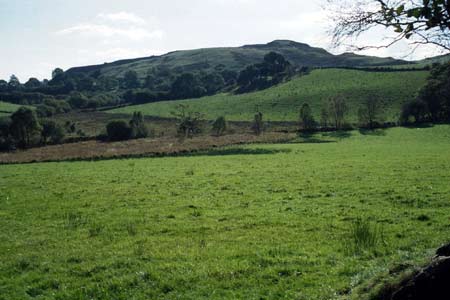
This is a landscape of gentle east-facing slopes ranging in height from 180m to 260m. These slopes are sheltered from the prevailing winds by higher ground to the west, and lie above poor quality, wetter ground to the east. Three widely dispersed farms are separated by a field system or systems of small irregular fields. Earth banks topped with hedges divide the fields. Hedges are generally in good condition, though some are becoming derelict and are supplemented by wire fences. Land-use is predominantly improved grazing, though there are pockets of rougher ground on lower slopes where drainage is impeded. Small stands of trees and the overgrown nature of some of the hedges lend a wooded aspect to this area.
Local stone is the traditional building material with slate (north Wales slate) used for roofs. Older farmhouses/houses date to the 19th century, are of two storeys and in the typical Georgian vernacular style – gable end chimneys, central front door, and two windows either side of the door and one above. A modern bungalow farmhouse is present. Stone-built outbuildings are generally confined to one or two. Working farms have ranges of modern steel and concrete agricultural buildings.
There is nothing in the archaeological record to indicate a time-depth element to this landscape. All the recorded archaeology consists of post-Medieval sites that are mostly deserted settlements.
This landscape character area is well defined. To the
north, south and west lies either a conifer plantation planted on former
unenclosed land, or unenclosed land. Lower lying, rough grazing lies to
the east.
Base map reproduced from the OS map with the permission
of Ordnance Survey on behalf of The Controller of Her Majesty's Stationery
Office, © Crown Copyright 2001.
All rights reserved. Unauthorised reproduction infringes Crown Copyright
and may lead to prosecution or civil proceedings. Licence Number: GD272221