Home > Historic Landscape Characterisation > Upland Ceredigion > |

 FULLBROOK
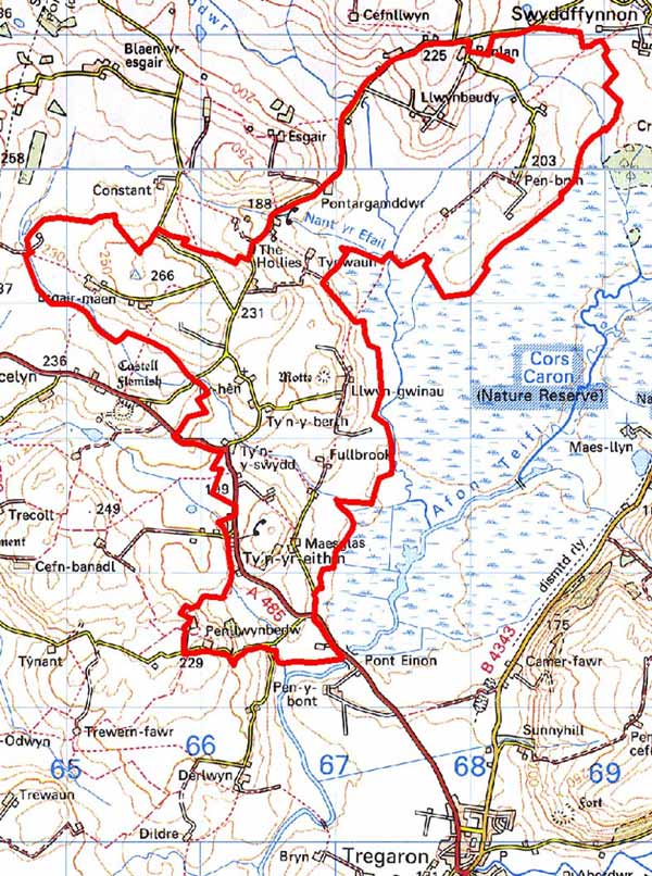
GRID REFERENCE: SN 668636
AREA IN HECTARES: 725.7
Historic Background
In the Medieval Period this area lay within Strata Florida Abbey’s Mefenydd Grange. A fulling mill is recorded here (Williams 1990, 59). At the Dissolution all Strata Florida’s holdings were granted to the Earl of Essex. Soon after the land in and around this area seems to have been purchased by the Lloyds of Ffosybleiddiaid and later acquired by the Vaughans of Crosswood. At the time of the tithe survey (Lledrod Tithe Map and Apportionment, 1844; Caron Tithe Map and Apportionment, 1845) the present settlement pattern and field systems had been established. Earlier estate maps provide little evidence as to how the landscape evolved. Fullbrook farm in 1819 (NLW Vol 45, 58) was surrounded by small enclosures with slightly larger, but still small, fields further out - a pattern detectable on modern maps. A late 18th century map (NLW Crosswood Vol 2, 10) covering the farms of Ty-y-swydd, Ty-hen and Tynbwlch shows a landscape similar to that recorded by the tithe surveyors except for sub-divided strips in multiple ownership in one field. This may be an indication that at least part of the modern enclosure pattern evolved out of a sub-divided field system, but at present place-names, such as Maes-glas, are the only other evidence to support this. At Ynys-y-bont the tithe map shows the farm surrounded by enclosures with the marshy, lower-lying area subdivided (presumably by drainage ditches) into larger, more regular enclosures. A late 18th century map (NLW Crosswood Vol 2, 19) however, shows the marshy area as undivided common land. Map evidence demonstrates that apart from Ynys-y-Bont farm this marshy area was originally common land, probably an extension of Cors Caron. In the late 18th century or early 19th century it was taken into private ownership and attempts made to drain it. Given the modern appearance of the land it is likely that this drainage was never particularly successful and the land soon reverted to marsh. Ynys-y-bont, as the name indicates, was and is a settlement on an island within a sea of marsh. In the 19th century a small clustered settlement developed close to Berth chapel (constructed 1840) at Ty’n yr eithen.

Description and essential historic landscape components
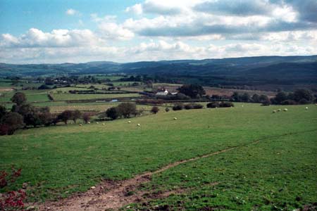
This is an area of undulating land to the west of Cors Caron. It ranges in height from 160m at its boundary with Cors Caron, to circa 230m on several rounded summits. It is a landscape of scattered farms and small, irregular fields. Earth banks with hedges form the boundaries to the fields. Hedges are generally in good condition and are stock-proof, though in the southern part of the area they are overgrown. Only on the higher ground are hedges becoming derelict and require augmenting with wire. Included in this area is a marshy area lying approximately at 160m on the west side of Cors Caron, but surrounding a island of higher ground at 170m on which the Ynys-y-bont Farm is situated. This area is characterised by rush covered ground and peat deposits and is divided by drainage ditches and wire fences. Most of the fields are under improved grazing. There are patches of poorer quality ground - rough pasture and rushes - close to Cors Caron, and peaty deposits in some hollows. There are many small stands of broadleaf trees, and these in combination with the overgrown hedges provide a moderately wooded aspect to the landscape in the southern part of the area.
Except for the cluster of late 19th century probable worker houses at Ty’n yr eithen, most of the buildings of this area have, or had, an agricultural function. Farms are small. Local stone is the traditional building material, with slate (north Wales slate) used for roofs, although blue brick is used on a late 19th century chapel and red brick on a couple of houses of similar date. Stone walls are either cement rendered, left bare or painted on houses (usually the former) and always bare on traditional farm buildings. Older farmhouses/houses almost entirely date to the mid-to-late 19th century, are relatively small, of two storeys and in the typical Georgian vernacular style, with gable end chimneys, central front door, and two windows either side of the door and one above. Strong vernacular traits such as low eaves, small windows and one chimney larger than the other are present on most houses rather than Georgian elements. Some farmhouses have recently been rebuilt and a scatter of late 20th early 21st century houses/bungalows is concentrated at the southern end of this area. Stone-built outbuildings are generally confined to one or two small ranges, with some attached and in-line to the house. Several farms are not now working and outbuildings are not in use. Working farms have medium to large ranges of modern steel and concrete agricultural buildings.
The recorded archaeology of this area is rich and varied, but dominated by post-Medieval sites such as a mill, bridges, dwellings, a chapel and a smithy. Sites of earlier periods provide time-depth to this landscape and include a Medieval motte, Castell Llwyn-gwinau, a Medieval mill site, and finds of Neolithic, Bronze Age and Roman date. Of particular note is a group of Bronze Age burnt mounds or hearths - possible settlement sites.
This area is particularly well defined to the east where it runs up against Cors Caron, but elsewhere it merges with its neighbouring areas.
Base map reproduced from the OS map with the permission
of Ordnance Survey on behalf of The Controller of Her Majesty's Stationery
Office, © Crown Copyright 2001.
All rights reserved. Unauthorised reproduction infringes Crown Copyright
and may lead to prosecution or civil proceedings. Licence Number: GD272221