Home > Historic Landscape Characterisation > Upland Ceredigion > |

 FFAIR RHOS
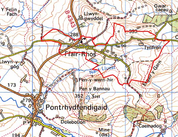
GRID REFERENCE: SN 745678
AREA IN HECTARES: 165.5
Historic Background
Ffair Rhos lay within Strata Florida Abbey’s Mefenydd Grange, and was granted a fair by the Abbey. Post-Dissolution, Ffair Rhos’s fairs were the greatest in Ceredigion. Fair days were 25 July, 15 August and 14 September, and in James I’s time were said to attract 5000-6000 people (Howells 1974/75, 270). Jones (1974, 17) states that one fair was still held in 1974. One of the attractions of the fairs was the transport links; Ffair Rhos is located at the junction of a major north-south route and an east-west route that passes over the mountains giving access to the towns of east Wales and England. The settlement pattern and land-use in the Medieval period is unknown. At the Dissolution of the Abbey its former lands were granted to the Earl of Essex, and in 1630 the Crosswood estate purchased most of them. A map drawn up for the Crosswood estate in 1815 (NLW Crosswood 347), which seems to have been for an enclosure act that was never awarded, shows a scatter of smallholdings across Ffair Rhos. No schedule accompanies the map, but it would seem that these were squatter settlements on common land, with perhaps some difference shown between those that had been established for 20 years or more, and so were to be granted legal title to the land, and those of less than 20 years. In the absence of an enclosure award, squatter settlement and small-scale enclosure seems to have continued apace in the first half of the 19th century, as the tithe map of 1847 (Gwnnws Tithe Map and Apportionment, 1847) records more cottages and smallholdings. Settlement reached its peak in the mid 19th century. Two chapels were constructed here, one in 1905 (Percival 1998, 523). It is now redundant. Many of the 19th century dwellings have been recently modernised, or are undergoing modernisation.
Description and essential historic landscape components
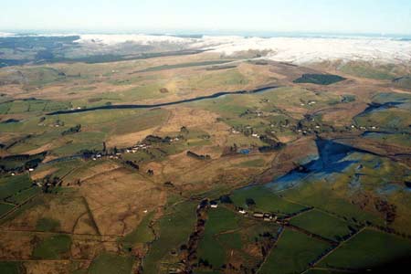
This area consists of an open upland valley or hollow between 240m to 400m centred on the hamlet of Ffair Rhos. Ffair Rhos is a small linear settlement on either side of a minor road surrounded by numerous dispersed farmsteads, cottages and smallholdings. Local stone is the traditional building material with slate (north Wales slate) used for roofs. Walls are usually cement rendered on houses and bare on traditional farm buildings. Older houses that almost all entirely date to the mid-to-late 19th century, are relatively small, and of two storeys or one-and-a-half storeys (although at least one single storey cottage is present). They are built in the typical Georgian vernacular style, with gable end chimneys, a central front door, and two windows either side of the door and one above, but with stronger vernacular traits such as low eaves and small windows on most houses rather than Georgian elements. Many of these houses have been recently modernised and extended. A short terrace of worker houses lies in Ffair Rhos, but most houses have (or had) an agricultural function, with stone-built outbuildings, generally confined to one or two small ranges, sometimes attached and in-line to the house. Several farms are not now working and outbuildings are not used or have been converted. Working farms have small ranges of modern steel and concrete agricultural buildings. There are a few modern houses/bungalows close to Ffair Rhos. Two small, disused chapels are present.
Land-use is rough pasture, tending towards ungrazed moor. Peaty deposits are common. Some improved pasture is present on lower ground towards the east end of the area. There are no significant stands of trees. The whole area has been parcelled up into an irregular field system. The boundaries to this system comprise earth banks or earth and stone banks. Hedges are not generally present except on the lower ground close to Ffair Rhos hamlet, but even here they are derelict and no longer stock-proof. Wire fences now top most of the older bank boundaries, and some new wire boundaries have been created. Many of the older enclosures on the higher slopes no longer function and have been merged into larger units. Williams (1990, 59) records a Medieval perimeter boundary to Ffair Rhos, but this has not been seen by the present author.
Apart from a minor metal a redundant chapel and mine; the recorded archaeology comprises several deserted cottages.
The boundaries of this landscape area are not particularly
well defined. To the north, east and west it fades into unenclosed moorland
or land that has now mostly reverted to moor. To the west lies land consisting
of large enclosures of improved and unimproved ground.
Base map reproduced from the OS map with the permission
of Ordnance Survey on behalf of The Controller of Her Majesty's Stationery
Office, © Crown Copyright 2001.
All rights reserved. Unauthorised reproduction infringes Crown Copyright
and may lead to prosecution or civil proceedings. Licence Number: GD272221