Home > Historic Landscape Characterisation > Upland Ceredigion > |

 DYFFRYN CASTELL
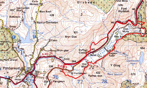
GRID REFERENCE: SN 780818
AREA IN HECTARES: 198.9
Historic Background
The early history of this area has not been researched. By the end of the 18th century part of this area had come into the possession of the Nanteos estate. Early 19th century estates maps (NLW Vol 45, 24, 26) show a landscape of scattered farms, enclosed land on the valley floor, with larger enclosures on the lower valley sides giving way to unenclosed land at higher levels. There has been, however, some sub-division of fields since then. For instance, in 1819, Troed rhiw-goch Farm consisted of a single dwelling in a very large enclosure, now it is sub-divided. It is likely that in general the settlement pattern and field system of the area dates to at least the late Medieval Period. In 1770, a turnpike, which passed through this area from Shrewsbury over to Devil’s Bridge and on to Aberystwyth, was opened. A new turnpike opened in 1812 and followed the course of the old from the east to the Dyffryn Castell Hotel where it branched off pursuing a more direct course to Aberystwyth through Ponterwyd. The current A44 follows this same route. Turnpikes clearly stimulated trade, resulting in the construction of the Dyffryn Castell Hotel, but it is not clear how much they stimulated the mining industry. The first large-scale mine in the area, Castell, began operations in 1785, but closed in 1803. It was reopened several times during the 19th century, finally closing in 1908 (Bick 1983, 10). Workings at Esgairlle mine may be of great antiquity as stone ore-dressing artefacts have been found here. Commercial workings started at this mine in 1846, closing in 1892 (Bick 1983, 10-11). The garden at Dyffryn Castell Hotel is recorded on the Welsh Historic Gardens Database.
Description and essential historic landscape components
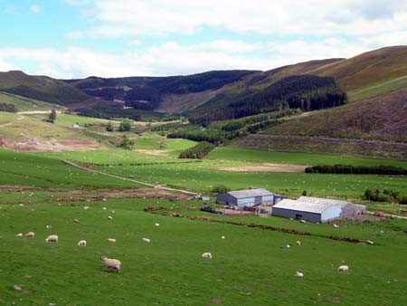
This area essentially consists of the valley floor and lower valley slopes of the Afon Castell, lying between 160m and 260m. Improved grazing land dominates, but rougher grazing lies on the steeper slopes, and peaty and rushy ground are evident in hollows on the valley floor. Improved grazing gives way to unenclosed moor or large forestry plantations at higher levels. Small conifer plantations are present in this area, but apart from these, it is a treeless landscape. The land has been divided into medium- to large-sized fields on the valley floor and large enclosures on the valley sides. These enclosures are formed from earth banks. Hedges no longer survive anywhere. Wire fences form stock-proof boundaries. At the Dyffryn Castell Hotel dry-stone walls define small paddocks; these walls are in poor condition. The two metal mines, Castell and Esgairlle, are prominent landscape components. Spoil tips and old workings are the most obvious landscape feature of these mines, but at Castell the old mine buildings are highly visible reminders of this once important industry. The sinuous course of the turnpike road, the present A44, on the northern valley side is a further distinctive and important landscape component of this area.
The settlement pattern is of dispersed farms located at the foot of the valley sides or terraces at higher levels. There is a scattering of deserted farms and cottages across the area. Local stone is the traditional building material with slate (probably north Wales slate) used for roofs. Walls are either cement rendered or bare stone houses. Most older farmhouses/houses date to the mid-to-late 19th century, are relatively small, of two storeys and in the typical Georgian vernacular style. One house of probable late 18th century date, of one-and-a-half storeys and in the vernacular tradition is present, and the Dyffryn Castell Hotel has strong Georgian traits. At least one modern farmhouse is present. Stone-built outbuildings are generally confined to one or two small ranges, with some attached and in-line to the house. Several farms are not now working and their outbuildings are not in use. The one clearly working farm has very extensive ranges of modern steel and concrete agricultural buildings. A group of detached modern agricultural buildings is also present.
Apart from the archaeology associated with the metal mining industry and deserted settlements, a Medieval moated settlement - Llys Arthur - lies within this area, as does the site of a possible Neolithic stone circle.
This is a very well defined landscape area. On all sides lie either high, unenclosed moorland or 20th century forestry.
Base map reproduced from the OS map with the permission
of Ordnance Survey on behalf of The Controller of Her Majesty's Stationery
Office, © Crown Copyright 2001.
All rights reserved. Unauthorised reproduction infringes Crown Copyright
and may lead to prosecution or civil proceedings. Licence Number: GD272221