Home > Historic Landscape Characterisation > Upland Ceredigion > |

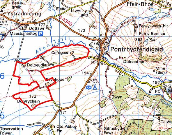
 DOLBEUDIAU - DOLYRYCHAIN
GRID REFERENCE: SN 712659
AREA IN HECTARES: 124.7
Historic Background
In the Medieval Period this area lay within Strata Florida Abbey’s Penardd Grange. As with other abbey granges it is likely that by the end of the Medieval Period, if not earlier, Penardd had been divided into farms that were leased out on a commercial basis. On the Dissolution of the abbey its lands were granted to the Earl of Essex, who subsequently sold them to the Crosswood estate in 1630. Crosswood estate maps are the earliest large-scale cartographic representation of the area. These maps of 1781 (NLW Crosswood Vol 1, 6 and 8) show a landscape under change. The farms of Dolbeudiau, Brynhope and Dolyrychain were all in existence, with each farm surrounded by a few, small fields separated by open, unenclosed ground. By the tithe survey (Caron parish 1845) the field system of today had been established - small- to medium-sized enclosures covering the whole area. Although it would require further research to substantiate, it is possible that the farms of this area were established on unenclosed land on the fringes of Cors Caron in the late Medieval or early modern period, in order to exploit the grazing and hay of the bog.
Description and essential historic landscape characteristics
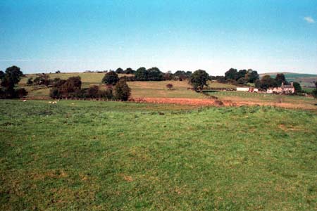
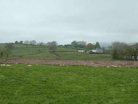
This area comprises a low undulating ridge between 160m and 210m bordering the western side of Cors Caron. To the west and north the land falls away rapidly to the bog, to the south and east more gentle slopes fade into lower-lying farmland. Field patterning comprises small, irregular enclosures close to the farms with more regular, medium-sized enclosures further out, and large fields on the slope overlooking Cors Caron. Boundaries are of banks of earth or stone-faced earth topped with hedges. Hedges are in fair condition on the lower eastern slopes, but elsewhere they are overgrown, neglected or derelict. Wire fences now provide the main stock-proof barriers. Improved pasture dominates, with patches of rougher, rushy ground in hollows. Apart from a small conifer plantation, there are few trees.
The settlement pattern is of dispersed farmsteads. Farms are slightly larger than average for the region. Local stone is the traditional building material with slate (north Wales slate) used for roofs. Walls are usually cement rendered on houses and left bare on traditional farm buildings. Farmhouses/houses almost entirely date to the 19th century, are of two storeys and in the typical Georgian vernacular style – gable end chimneys, central front door, and two windows either side of the door and one above. Most houses have stronger Georgian traits – large windows, high rooms and a symmetrical plan/elevation – rather than vernacular elements. Stone-built outbuildings consist of several ranges set semi-formally around yards, although smaller buildings positioned informally are present on smaller farms. Working farms have substantial ranges of modern steel and concrete agricultural buildings.
The only recorded archaeology in this area consists of a post-Medieval cottage.
This area is well defined by Cors Caron to the west and
north, but elsewhere, this area tends to merge with its neighbours.
Base map reproduced from the OS map with the permission
of Ordnance Survey on behalf of The Controller of Her Majesty's Stationery
Office, © Crown Copyright 2001.
All rights reserved. Unauthorised reproduction infringes Crown Copyright
and may lead to prosecution or civil proceedings. Licence Number: GD272221