Home > Historic Landscape Characterisation > Upland Ceredigion > |

 DAREN
DAREN
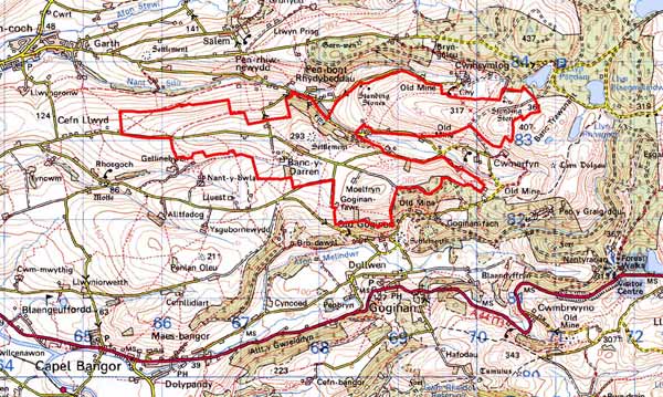
GRID REFERENCE: SN 681829
AREA IN HECTARES: 428.6
Historic Background
The early history of this area is not known. It did not lie within a monastic grange, as did the majority of neighbouring land. By at least the 18th century, and probably considerably earlier, the Gogerddan, Powis Castle and Court Grange estates had acquired much of the land. It is likely that for several centuries rough, unenclosed grazing characterised this area, though Daren Farm is perhaps of some antiquity. Late 18th century estate maps (NLW Gogerddan 68, 67; Powis Castle 164; Scott Archer 20; Vol 37, 64; R.M. 108) depict almost all of this area as unenclosed. The main exception is Daren Farm, but even here the dwelling sits in a large block of unenclosed sheep-walk. An interesting map is that of 1788 (NLW R.M. 108), wherein the open ridge of this area has been annotated by a later hand, dividing it into a series of large, regular enclosures and new farms. The date of this alteration is not certain, but it had occurred by the tithe survey of 1845 when the whole of this area had been enclosed and several new farms established. Important elements of this landscape are the remains of the metal (mainly lead) mining industry. Daren is an ancient mine, perhaps of Roman origin. It was worked in the 17th century, and though production ceased for almost a century, it was reopened and worked in the 18th and 19th centuries. Cwm Daren and Twll y Mwyn mines also lie within this area. Though not as ancient as Daren, they were worked from the 17th century with production at the latter only ceasing in the 1920s (Bick 1988, 10-16). The small settlement of Daren was established to serve the lead mines in the 19th century.
Description and essential historic landscape components
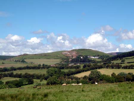
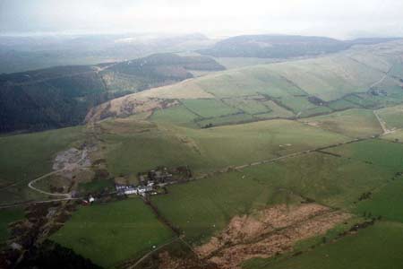
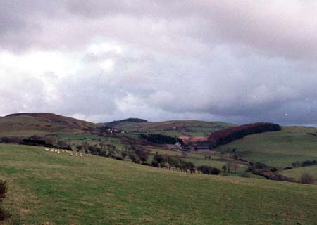
This area encompasses the high points and flanks of two rounded ridges: Daren and Banc Cwmerfyn. 342m is the highest point, with the flanks at the western end descending to approximately 100m. There are rocky outcrops on the summits. Apart from very steep slopes, which are under rough grazing or bracken, and some peaty and rushy hollows, all farmland consists of improved grazing. There are forestry plantations and small stands of deciduous woodland on very steep slopes, but otherwise this is essentially a treeless landscape. The area has been divided into a series of large fields by banks of earth and stone. These banks were formerly topped with hedges, but apart from at the lowest levels and close to farms all hedges have gone, and where they do survive they are overgrown and derelict. Wire fences now provide stock-proof boundaries, and divide the area into very large enclosures. The overall appearance is of an unenclosed landscape of improved grazing.
The settlement pattern is of dispersed hill farms. Local stone is the traditional building material with slate (probably north Wales slate) used for roofs. Walls are usually cement rendered or left bare on houses and bare on traditional farm buildings. Older farmhouses/houses that almost all date to the mid-to-late 19th century, are relatively small, of two storeys and in the typical Georgian vernacular style – gable end chimneys, central front door, and two windows either side of the door and one above. Several new/rebuilt farmhouses have replaced older buildings. Stone-built farm outbuildings are generally confined to one or two small ranges. Some farms are not now working and outbuildings are not in use or have been demolished. Working farms have small ranges of modern steel and concrete agricultural buildings. The remains of deserted farmsteads or cottages, surrounded by enclosures defined by low, broken-down stonewalls are scattered across the landscape. A group of 19th century worker houses lies at Banc-y-Daren, which also includs a short terrace, detached houses, and several abandoned/ruined dwellings. Evidence of the former metal mining industry is a prominent component of the landscape, with tips, shafts open-casts and other features following the lead vein from the its high point at Daren.
The remains of the metal mining industry dominate the archaeological record. Workings cut across Daren Iron Age hillfort, an important element in the landscape. It is prominent on account of its location on the summit of a ridge at 290m. Further time-depth to the landscape is provided by three Bronze Age standing stones and a Bronze Age round barrow. A place-name indicates the possible location of a further standing stone.
This is a distinct landscape bounded by areas that have quite different characteristics. To the east lies unenclosed upland and forestry, whereas elsewhere lower-lying enclosed land exists, sometimes containing metal mine workings.
Base map reproduced from the OS map with the permission
of Ordnance Survey on behalf of The Controller of Her Majesty's Stationery
Office, © Crown Copyright 2001.
All rights reserved. Unauthorised reproduction infringes Crown Copyright
and may lead to prosecution or civil proceedings. Licence Number: GD272221