Home > Historic Landscape Characterisation > Upland Ceredigion > |

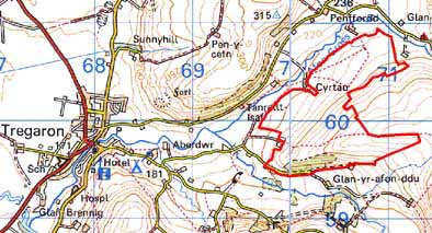
 CYRTAU & BRYN-HOWNANT
GRID REFERENCE: SN 705601
AREA IN HECTARES: 117.8
Historic Background
The early history of this area is unclear. It may have formed part of one of the granges of Strata Florida Abbey, or part of the demesne of the abbey. The granges were granted to the Earl of Essex upon the Dissolution, who sold them to the Crosswood estate in 1630. In the late 18th century some land in this area was in the possession of Crosswood, and may have been obtained by this route. John Stedman acquired Abbey demesne in 1567. However, Richard Stedman died intestate in 1746 and the estate passed to the Powells of Nanteos. Nanteos had considerable holdings in this area in the 19th century. It is likely that by the end of the Medieval Period, if not earlier, abbey granges and demesne were divided into farms that were leased out on a commercial basis. There is also evidence that some holdings in this area, by the 18th century, were in the possession of another estate, that of Thomas Johnes’s Llanfair Clydogau estate, which may have come to him through the purchase of part of the Bishop of St David’s Llanddewibrefi estate. Whatever the tenurial system, this landscape has changed considerably over the past 200 years. An 1819 estate map (NLW Vol 45, 70) shows the area around the later established Waun-Gota farm (Waun-Gota farm was not established until after 1845) as unenclosed with intermixed strips, but to the east of Cyrtau as medium-sized fields. An earlier map of 1791 (NLW Vol 36, 151) depicts the hillside to the east of Bryn-Hownant as dispersed, strip enclosures. By the tithe survey of 1845 (Caron Tithe Map and Apportionment) only a few strips close to Waun-Gota were recorded; the remainder having been enclosed. From these historical map sources it would seem that this block of regular, medium-sized enclosures has evolved from a subdivided field system (almost certainly shared pasture and not arable), which was still partly operational through to the early-mid 19th century. On modern maps the area of former strip enclosures in the vicinity of Waun-Gota farm is depicted as a series of rectangular enclosures aligned northwest to southeast. The holding known as Waun-Gota has been created out of the earlier strip system. As in other areas demographic pressures and changes underlie this 19th century pattern: extreme pressure on marginal land in the first half of the century, emigration, depopulation and the combining of holdings in the latter.
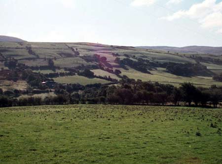
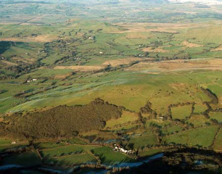
Description and essential historic landscape components
An area of regular, medium-sized enclosures on gentle northwest and southwest facing slopes of the Afon Groes between 200m and 320m. Earth banks topped with hedges form the enclosures. On the lower slopes the hedges are in fair condition, higher up the slopes they are derelict, and on the highest levels they have been replaced with wire fences, even where they are in fair condition hedges are supported by wire fences. Improved pasture dominates the area, though at the northeast end near to Waun-Gota there is a considerable tract of poor quality grazing and rushy ground. There are no settlements in this area.
The only recorded archaeology consists of a post-Medieval cottage.
Boundaries are not well defined between this area and lower-lying ground, but towards higher, unenclosed land the definition is clearer.
Base map reproduced from the OS map with the permission
of Ordnance Survey on behalf of The Controller of Her Majesty's Stationery
Office, © Crown Copyright 2001.
All rights reserved. Unauthorised reproduction infringes Crown Copyright
and may lead to prosecution or civil proceedings. Licence Number: GD272221