Home > Historic Landscape Characterisation > Upland Ceredigion > |

 CWMNEWIDION
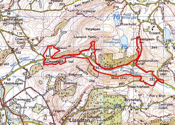
GRID REFERENCE: SN 710745
AREA IN HECTARES: 128.0
Historic Background
By the early 17th century Cwmnewidion was a small independent estate owned by Hugh Vaughan (no relation to the Vaughans of nearby Crosswood), and comprised within this landscape character area Cwmnewidion Isaf and mill, Gilwern, and two Rhos-rhudd farms (Morgan 1997). As Morgan states (p23), the origins of the wealth and status of the families of these small estates are lost. The Vaughans of Cwmnewidion were, however, sufficiently wealthy to have acquired ex-Strata Florida grange lands in Cwmystwyth. In the 1780s the Crosswood estate purchased the Cwmnewidion estate (Morgan 1997, 196). Late 18th century estate maps indicate that a similar field patterning to todays was then present (NLW Crosswood Deeds 5, Ser IV, Vol 1; 18 & 42). The map of Cwmnewidion shows enclosed land on the valley floor, and heavily wooded valley sides with unenclosed land above. A similar pattern is shown on the Llanerchpentir map. From the mid 19th century lead mining became an important element in the economy of the area. Several mines, Red Rock, West Frongoch, Wemyss and Graiggoch worked the western limits of the Frongoch lode (Bick 1974, 16-17). Wemyss at the eastern end of Cwmnewidion was worked from 1861 to 1899, and Craiggoch from 1841 to 1889, although here evidence of earlier workings was noted in 1840. A chapel was constructed here in the 19th century.
Description and essential landscape components
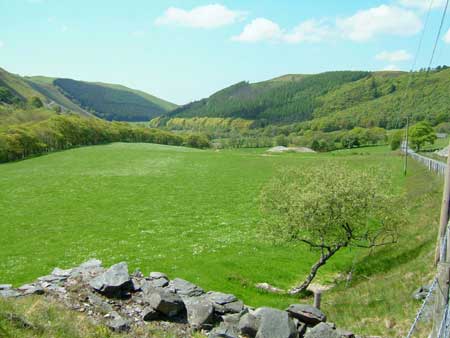
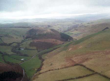
Cwmnewidion is a narrow, steep-sided valley. The floor of the valley rises from 100m at the western end to over 200m at the east. The valley sides rise to over 300m. The landscape area includes the valley bottom and the lower slopes of the valley sides, but not the higher slopes. A minor road, but nevertheless an important local route-way, runs along the northern side of the valley floor linking the fertile lands of the lower Ystwyth valley with Pontrhydygroes and Cwmystwyth. The settlement pattern is of dispersed farmsteads located at the foot of the steep valley sides with enclosed land spread across the valley floor. Enclosures are small and irregular and are formed by low earth banks. Banks were formerly topped with hedges, but apart from in the extreme western part of the area these hedges have gone and are now replaced by wire. Improved grazing predominates on the valley floor, giving way to poorer quality land on the lower slopes. Land here is enclosed into larger divisions, but the earth bank boundaries are redundant and replaced by wire. There are stands of deciduous woodland and 20th century forestry at the western end of the area.
Included in this area is the stone-built two storey Georgian farmhouse of Cwmnewidion Isaf, built by the Trawscoed Estate, with its range of stone outbuildings arranged formally around a courtyard a little distance from the house, as is usual with a “gentleman’s” residence. Other farms are more modest, with rendered stone houses dating to the mid-to-late 19th century of two storeys and in the typical Georgian vernacular style – gable end chimneys, central front door, and two windows either side of the door and one above. One house at least has strong vernacular traits. Some farmhouses have been replaced by modern dwellings and there are several other modern dwellings and/or heavily modernised older houses in this area. Most older farm buildings are relatively small, of stone and probably date to the 19th century, although 20th century brick structures are also present. Apart from one farm, modern agricultural buildings are not large, and indeed, several farms are not now working, have no modern buildings, and their old outbuildings are not used.
The remains of the metal mining industry are an important and distinctive element in this landscape. These are concentrated towards the eastern end of the valley and comprise dominant spoil heaps and mine buildings. The mine buildings constructed of local stone are roofless, but stand in some instances to their original full height. The buildings include a generating station at Frongoch mine that was supplied by a pipeline from a reservoir to the north.
Other than metal mine remains; the recorded archaeology consists of a mill site and a chapel.
The borders of this area are well defined with steep
valley sides to the north, west and east. However, at the open western
end of the valley this landscape area forms no clear boundary with the
enclosed land of neighbouring areas.
Base map reproduced from the OS map with the permission
of Ordnance Survey on behalf of The Controller of Her Majesty's Stationery
Office, © Crown Copyright 2001.
All rights reserved. Unauthorised reproduction infringes Crown Copyright
and may lead to prosecution or civil proceedings. Licence Number: GD272221