Home > Historic Landscape Characterisation > Upland Ceredigion > |

 CWM GWYDDYL
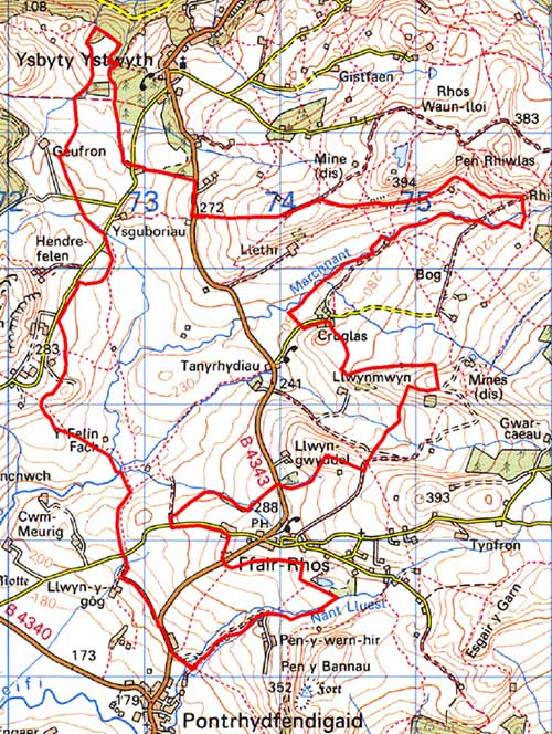
GRID REFERENCE: SN 740693
AREA IN HECTARES: 596.9
Historic Background
In the Medieval Period this area lay within Strata Florida Abbey’s Mefenydd Grange. In common with other granges, it is likely that by the end of the Medieval Period Mefenydd was split into individual farms that were leased out on a commercial basis. This is the possible origin of the farms in this area. On the Dissolution Strata Florida’s lands were granted to the Earl of Essex. In 1630, the Crosswood estate purchased most of them. This area appears to have been marginal and dynamic and historical maps confirm the dynamic nature of the landscape (Gwnnws Tithe Map and Apportionment, 1847; NLW Crosswood Vol 1, 66, 68; NLW Crosswood 334; NLW Crosswood 340; NLW Morgan Richardson Deposit No 4 & 5). Late 18th and early 19th century estate maps show a variety of landscape types. In the south the area Bryn Capel is shown unenclosed, and that around Llethr Farm is shown as several small fields in unenclosed sheep-walk; Ysguboriau and Tynpontpren are similarly depicted. Generally in this period the area is one of scattered farms with small fields or paddocks set in unenclosed land. By the tithe survey (Gwnnws 1847) there had been enclosure of some of the sheep-walks and sub-division of larger fields. This process seems to have continued throughout the 19th century. In the 20th century the agricultural system went into decline, with the abandonment of farms and cottages. Many fields have been allowed to revert to rough pasture.
Description and essential historic landscape components
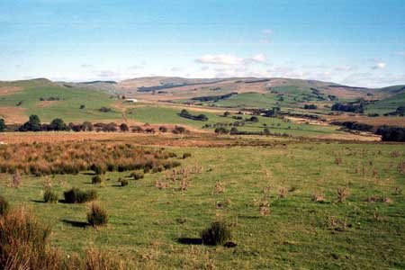
This area consists of an extensive wide, open valley that now contains a misfit stream. It ranges in height from 200m at the southern and northern ends to 340m on the eastern flanks. The appearance of a homogeneous area of unenclosed rough grazing and moorland, interspersed with improved pasture belies a complex landscape history. All of this area was formerly enclosed. The field size varies greatly from small to large, the smaller enclosures usually closer to farmsteads. The types of boundaries vary, but the most common type is the earth bank. Stone-faced banks and occasional dry-stone walls are also present. Hedges either no longer exist or are very derelict and are supplemented with wire fences. Very occasionally boundaries are formed by ditches. Many fields have either been merged to form larger units, or are no longer in use. The overall impression of this area is of very rough grazing, tending towards moorland with peaty deposits in hollows. There are, however, considerable blocks of improved grazing. These tend to be located where the field system has been maintained. The settlement pattern is of dispersed farmsteads and cottages, including several deserted sites. Several small conifer plantations are scattered across the landscape, but apart from these the area is essentially treeless. Remains of the metal mining industry are scattered across the eastern part of the area, but these are minor in comparison with the remains in the neighbouring area to the east.
Older buildings probably date to the mid-to- late 19th century and are built of stone which is typically cement rendered on houses and left bare on outbuildings. Houses are of two storeys in the regional Georgian vernacular style –gable end chimneys, central front door, two windows either side of the door and one above. Stronger vernacular traits such as low eaves, an asymmetrical floor plan, small windows and one chimney larger than the other are present on some houses. Some farmhouses have been rebuilt/renovated or replaced by modern houses or bungalows. Nineteenth century farm outbuildings are generally small and of one or two ranges, but there are a couple or larger examples on some farms. The range of farms as indicated by their buildings is not great, but different scales are present as evidenced by smaller farms having a single range of outbuildings attached to and in-line with the house, through to larger farms with their buildings set more formally around a yard. Most working farms have small modern steel and concrete agricultural buildings, but there are a couple of examples of very large modern buildings. There are several deserted cottages, houses and cottages in this landscape.
In addition to abandoned cottages and the remains of the metal mining industry, two Bronze Age standing stones represent the recorded archaeology of this area. These provide a time-depth to the landscape.
The borders of this area are not particularly well defined
to the east and west, with the pattern of large enclosures and poor quality
land replicated in these neighbouring areas. To the north and south and
southwest there is some better definition where blocks of improved pasture
and smaller enclosures are found.
Base map reproduced from the OS map with the permission
of Ordnance Survey on behalf of The Controller of Her Majesty's Stationery
Office, © Crown Copyright 2001.
All rights reserved. Unauthorised reproduction infringes Crown Copyright
and may lead to prosecution or civil proceedings. Licence Number: GD272221