Home > Historic Landscape Characterisation > Upland Ceredigion > |

 CWMERFYN
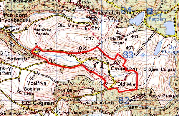
GRID REFERENCE: SN 692827
AREA IN HECTARES: 96.8
Historic Background
The history of this area has not been researched. It is likely that the pattern of dispersed farms and small irregular fields is of some antiquity. Superimposed over this agricultural landscape is evidence of the metal mining industry. Cwmerfyn is an ancient mine, and originates well before the workings of Myddelton and Bushell mines in the first half of the 17th century. It lay idle from 1795 to 1810, but was greatly developed in the 1840s and 1850s by Matthew Francis. It finally closed in 1877 (Bick 1988, 6-8). Bwlch or Bwlch Cwmerfin mine also lies within this area. This is less ancient than Cwmerfyn, but is recorded as working in the first decade of the 18th century. In the 19th century the Bwlch United Company worked it with Pwllrhenaid mine, but output was disappointing and the mine finally closed in 1884 (Bick 1983, 38-42). A small settlement developed to serve the mines, cottages were constructed, and two chapels were built in 1866 and 1868 (Percival 1988, 517). Since the mines closed there has been a slow retreat of settlement.
Description and essential historic landscape characteristics
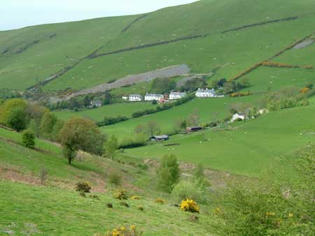
This complex landscape area occupies the floor and lower slopes of the upper valley of a tributary of the Nant Silo at between 200m and 300m. To the north, south and east the valley sides rise steeply to over 400m. This is a landscape of dispersed farms, industrial remains, housing and small irregular enclosures. Earth banks topped with hedges and occasional dry-stone walls are the most common boundary types. Hedges are derelict at higher levels and generally overgrown, and are no longer stock-proof at lower levels. Dry-stone walls are in a poor state of repair. Wire fences supplement all boundaries. Farmland is mostly improved grazing, though there are rushy patches on the valley floor, and bracken and rough grazing on some steep slopes. Some small stands of deciduous woodland are present. Abandoned cottages and farmsteads testify to the decline of population. The metal mines have been subjected to a programme of environmental improvements. Despite this, industrial remains are the single most dominant element of the landscape. These include tips, shafts, open-casts, a tramway and various ruined buildings.
The farmhouses of this area are probably mostly of mid-to-late 19th century date, although elements of some houses suggest an early 19th century date, or earlier. They are stone built, generally rendered, of two storeys and in the typical regional Georgian vernacular style, with gable end chimneys, central front door, and two windows either side of the door and one above. Most have strong vernacular traits such as low eaves, an asymmetrical floor plan, small windows and one chimney larger than the other. One farmhouse is brick built and probably late 19th century. Farmhouses and farms are small and usually have small ranges of stone-built 19th century outbuildings and small modern agricultural buildings. Four short terraces of 19th century cement rendered/painted stone-built two storey vernacular worker cottages/houses lie alongside a lane. There are a few other 19th century worker houses in the area plus some late 20th century houses, including two low energy houses.
The recorded archaeology comprises almost exclusively 19th century standing buildings and the remains of the metal mining industry. However, limited time-depth to the landscape is provided by a documentary reference to a Medieval or early modern pillow mound or rabbit warren.
This is a very distinctive and well-defined area. On
all sides land rises steeply onto unenclosed or semi-enclosed land, or
onto forestry.
Base map reproduced from the OS map with the permission
of Ordnance Survey on behalf of The Controller of Her Majesty's Stationery
Office, © Crown Copyright 2001.
All rights reserved. Unauthorised reproduction infringes Crown Copyright
and may lead to prosecution or civil proceedings. Licence Number: GD272221