Home > Historic Landscape Characterisation > Upland Ceredigion > |

 CEFN-MEURIG
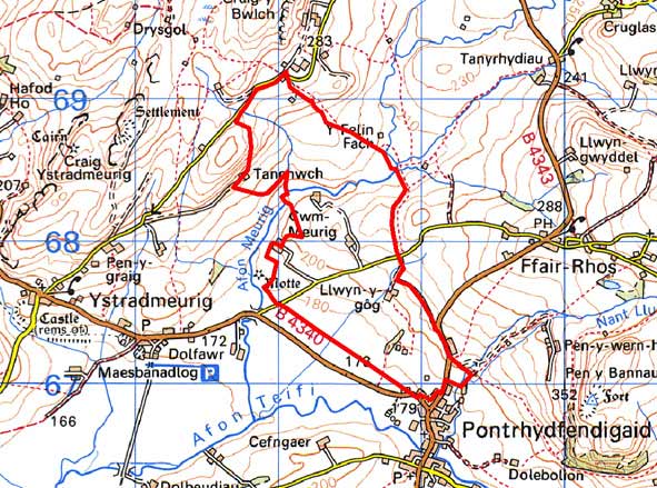
GRID REFERENCE: SN 725680
AREA IN HECTARES: 166.4
Historic Background
In the Medieval Period part of this character area lay
within Strata Florida Abbey’s grange of Mefenydd.
At the Dissolution the Earl of Essex was granted numerous abbey lands,
the greater portion of which was purchased by the Crosswood estate in
1630, including land found in this area. As with other granges owned by
Strata Florida, it is likely that Mefenydd had been divided into farms
which were let on a commercial basis by the end of the Medieval Period,
if not earlier. The settlement pattern in this area may therefore have
originated in the 15th or 16th century. On historic maps this area comprises
several disparate types of landscape. The tithe maps (Gwnnws Tithe Map
and Apportionment, 1847; Ysbyty Ystwyth Tithe Map and Apportionment, 1848)
show it partly unenclosed, and partly enclosed with both small and large
enclosures. Earlier, late 18th century estate maps (NLW Crosswood Deeds
Vol 1, 68; Morgan Richardson Dep. 4) of Cefn Meurig farm, Cloddiau farm
and a farm that no longer exists, show a similar pattern with the farmsteads
set in a cluster of three or four small fields surrounded by a system
of larger fields or unenclosed land. Clearly from at least the late 18th
century there was a process of carving out smaller fields from larger
ones. This process was still in operation at the time of the tithe survey,
but seems to have been completed by the mid-to-late 19th century. Since
the late 20th century the field systems have been in decline.
Description and essential historic landscape components
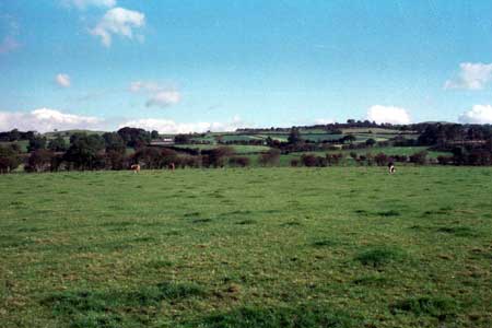
An area of sloping ground rising from 180m close to the village of Pontrhydfendigaid at its southeastern end, to almost 300m towards the northwest. The historic landscape components consist of small irregular fields and scattered farms and houses. On the southeastern lower slopes boundaries consist of earth banks and hedges. Hedges are in fair to good condition, though some are supplemented with wire fences. On the higher slopes the condition of the hedges becomes poorer and the nature of the boundaries shows some change, with stone and earth banks and derelict dry-stone walls intermixed with earth banks. At the highest levels, at the northwest end, the landscape is becoming derelict. There are some small stands of deciduous woodland. On the lower levels improved pasture dominates, becoming less prevalent on the upper slopes. At these higher levels a greater proportion of the land consists of rough grazing with bracken cover, though improved land is still present.
Stone, generally rendered on dwellings and left bare on agricultural outbuildings, is the traditional building material, with slate for roofs. Older houses that probably date to the mid-to-late 19th century, are relatively small, of two storeys and in the typical Georgian vernacular style – gable end chimneys, central front door, two windows either side of the door and one above. Some of the farmhouses have been modernised and some others recently rebuilt. Stone outbuildings are relatively small and of two or three ranges. Modern steel and concrete agricultural buildings are not substantial. There is also a scattering of modern houses and bungalows across the area.
Recorded archaeology comprises a small metal mine, and a possible Bronze Age cremation. The boundaries of this area are fairly well defined. To the north and northeast this area fades into the neighbouring area - a landscape of large enclosures and rougher grazing. To the north and northwest lies more open ground, and to the south is a regular field system.
Base map reproduced from the OS map with the permission
of Ordnance Survey on behalf of The Controller of Her Majesty's Stationery
Office, © Crown Copyright 2001.
All rights reserved. Unauthorised reproduction infringes Crown Copyright
and may lead to prosecution or civil proceedings. Licence Number: GD272221