Home > Historic Landscape Characterisation > Upland Ceredigion > |

 BWLCHDDWYALLT & BLAENGORFFEN
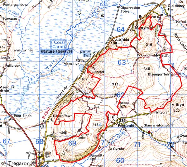
GRID REFERENCE: SN 704621
AREA IN HECTARES: 621.8
Historic Background
In the Medieval Period, most of this area lay within Strata Florida Abbey’s Pennardd Grange (Williams 1990, 56). Towards the end of the Medieval Period, if not earlier, the grange would have been divided into farms that were leased out on a commercial basis (Rees 1936, 58). Upon the Dissolution most of the abbey lands were granted to the Earl of Essex and were subsequently purchased, in 1630, by the Crosswood estate. Demesne land was acquired by John Stedman, which in 1746 passed to the Nanteos estate. The pattern of dispersed farms is therefore likely to date to at least the end of the Medieval Period, and was maintained by later estate owners. It was certainly established by the mid 19th century - dispersed farms surrounded by small irregular enclosures set amongst large enclosures are shown on the 1845 tithe map (Caron Tithe Map and Apportionment). Early estate maps demonstrate that the process of enclosure was still underway in the early 19th century. For instance, the maps show the ridge to the southeast of Sunnyhill (NLW Vol 45, 54, 66, 68) as unenclosed sheep-walk with a scatter of small, isolated fields in different ownership - possible squatter settlements? - and Bwlchddwyallt farm (NLW Crosswood 332; NLW Crosswood Vol 1, 14) is shown as an isolated farm surrounded by five small fields set in unenclosed land.
Description and essential historic landscape components
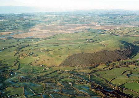
A southwest to northeast aligned ridge rising from 200m on the northwest-facing slopes to a maximum of 346m. Slopes are generally steep. Virtually the whole of the agricultural land of the area including the ridge summits is improved pasture, though strips of rough grazing lie on steep slopes, and rushy ground in some hollows. Stands of deciduous woodland exist on some of the steep slopes and as clumps scattered across the area. This combination of scattered woodland and improved pasture gives an (misleading) impression of unenclosed 18th century parkland. The settlement pattern is of dispersed farms that sit in a field system of large irregularly shaped enclosures, with smaller fields surrounding the farmsteads. Old boundaries are of earth banks topped by hedges, but these are now generally redundant. Hedges are now stock-proof only on lower levels; elsewhere they are either derelict or non-existent and have been replaced by wire fences. New wire fences also demarcate some new large enclosures.
There is little recorded archaeology in this area. However, a major site, Castell Tregaron, an Iron Age hillfort is present, and further time-depth to the landscape is provided by finds of Bronze Age date.
The boundaries of this area are well defined. To the east lies unenclosed land and to the south, west and north are lower-lying areas characterised by small, irregular enclosures.
Base map reproduced from the OS map with the permission
of Ordnance Survey on behalf of The Controller of Her Majesty's Stationery
Office, © Crown Copyright 2001.
All rights reserved. Unauthorised reproduction infringes Crown Copyright
and may lead to prosecution or civil proceedings. Licence Number: GD272221