Home > Historic Landscape Characterisation > Upland Ceredigion > |

 BWLCHCRWYS
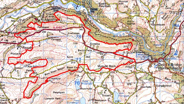
GRID REFERENCE: SN 701771
AREA IN HECTARES: 834.0
Historic Background
As with neighbouring areas, the early history of this area has not been researched. By the 18th century it had been divided between the Crosswood and Nanteos estates. Late 18th and early 19th century estate maps (NLW Crosswood Deeds No. 5, Ser IV, Vol 1, 16; NLW Vol 45, 31 32, 39, 41; NLW Nanteos 349 and 312) show that during this period large tracts of land were unenclosed sheep-walk - Cefn Garreg, Cefn Banal and Banc Cae Magwr. Farmsteads were isolated and usually possessed one or two small fields next to the dwellings set in a sea of unenclosed sheep-walk, or as at Cennant small fields adjacent to the farm and larger enclosures further out. In some instances farms did not even have paddocks or small fields. At Bwlchcrwys in 1764 (NLW Nanteos 312) the boundary of the farm seems to have been demarcated by a bank, hedge or fence, but no internal divisions were present and the farmhouse was located in ground labelled ‘Clear Open Ground’ and ‘Turbary’. By the time of the tithe survey of the 1840s much of the former unenclosed land had been formed into large fields and sub-division of the large enclosures had taken place. Further enclosure occurred in the latter half of the 19th century.
Description and essential historic landscape components
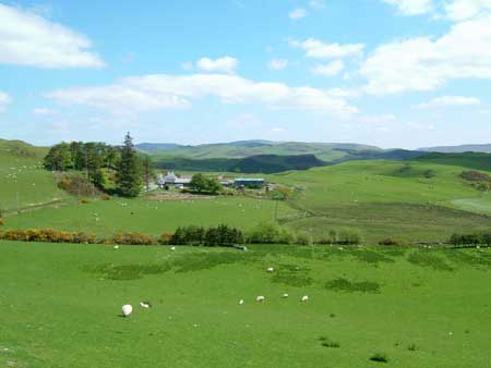
This moderately large landscape area consists of several east-west aligned, rounded ridges that achieve a height of 340m, separated by valleys at 200-280m. Apart from 20th century small-scale coniferous plantations it is essentially a treeless landscape. Almost all land is under improved grazing, though pockets of peaty and rushy ground lie in some hollows, and rough pasture is present on steep slopes. Old field boundaries comprise earth banks. No hedges are present except for occasional derelict and/or overgrown examples close to farmsteads. Wire fences now divide the area into large and very large enclosures, with some fences following the old bank boundaries. The overall appearance of this area, especially when seen from a distance, is of improved, unenclosed land. Evidence of old small-scale mining is present, and small reservoirs are presumably associated with these mines. Crossing the area from west to east is the A4120. This former turnpike road was the main route to the east out of west Wales prior to the construction of a new turnpike - the present A 44 - in 1829 (Coyler 1984, 180).
Dispersed farms characterise the settlement pattern. There is very little non-agricultural settlement and few modern dwellings that are not attached to a farm. Farmhouses are mainly two storey, mid to late 19th century, stone built and rendered, and in the typical Georgian vernacular style of the region, although at least one house is modern and others have been heavily modernised. Most have two or three ranges of stone outbuildings, sometimes arranged semi-formally around a yard, and working farms have large ranges of modern agricultural buildings. Two chapels testify to past relatively high population levels.
Recorded archaeology in this area provides time-depth to the landscape. Two Bronze Age round barrows and a possible third are present. An Iron Age hillfort is located to the northeast of the area, and earthworks in the northwest are probable evidence of a second. Most of the archaeological remains are associated with the metal mining industry, though old quarries are a distinctive feature of the landscape, and the place-name Felinwynt probably refers to the site of a windmill.
To the north the bounds of this area are particularly well defined against the steep and heavily wooded valley side of the Rheidol. The deep valley of Cwm Magwr defines the area to the southwest. To the northeast is a landscape of small fields and a nucleated settlement, and to the east land which was formerly unenclosed. To the south the landscape contains a denser scatter of settlements and an (mostly) intact old field system. A squatter settlement lies to the east.
Base map reproduced from the OS map with the permission
of Ordnance Survey on behalf of The Controller of Her Majesty's Stationery
Office, © Crown Copyright 2001.
All rights reserved. Unauthorised reproduction infringes Crown Copyright
and may lead to prosecution or civil proceedings. Licence Number: GD272221