Home > Historic Landscape Characterisation > Upland Ceredigion > |

 BRYNGWYN BACH
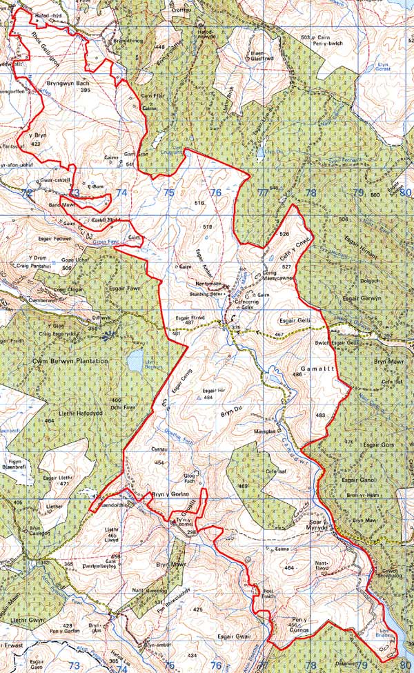
GRID REFERENCE: SN 757574
AREA IN HECTARES: 3916
Historic Background
This extremely large historic landscape character area crosses from Ceredigion into Carmarthenshire. It is entirely upland and included within it are parts of the Bishop of St David’s Llanddewi Breifi estate and Strata Florida Abbey’s Penardd Grange. It is likely that by the late Medieval Period both of these holdings would have been divided into farms, which were leased out and farmed on a commercial basis. The antiquity, however, of all the upland farms contained within this area is uncertain, and while it is likely that some originated in the Medieval Period in the manner indicated above, others may well have started as squatter settlements in the 18th or early 19th century. The 20th century has witnessed an abandonment of these farms, and only a handful are now occupied. The surviving chapel at Soar y Mynydd testifies to the once more populated nature of this area. The farms are clearly an important element in the landscape, but the vast majority of the land in this area is, and has been for at least the last few centuries, unenclosed, and would have been claimed by the Crown. Crossing the area are important trans-mountain natural route-ways linking the farming communities of Ceredigion with lands and towns to the east. These trans-mountain route-ways are celebrated for their use by drovers in the historical period, but they are likely to be of great antiquity, and not only provided communication across the Cambrian mountain chain, but allowed access onto the high moorland for the establishment of permanent or seasonal settlement, for the grazing of animals and for peat cutting.
Description and essential historic landscape components
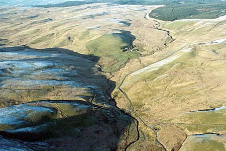
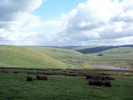
This is a very large tract of unenclosed upland with an uneven and widely dispersed settlement pattern of upland farms. At the northern end unenclosed land runs down to as low as 200m, but with heights of over 500m achieved in the central area. On average the height range is between 300 and 450m. The landscape is rarely craggy, and wide stretches of undulating moor with blanket bog on higher levels and peaty hollows are the norm. There is abundant evidence of deserted settlements across this area, particularly along the route-ways. Occupied farms, of note is Nantymaen, are traditionally stone built, surrounded by a collection of modern farm buildings, and situated within a system of just a few fields. Older boundaries of these fields consist of earth banks, but wire fences now provide the stock-proof barriers. These fields now comprise improved pasture, and there are further blocks of unenclosed improved pasture close to the farms. Apart from a block of recent forestry, this is a treeless landscape.
The recorded archaeology of this area is rich and varied. Considerable time-depth to the landscape is provided by the numerous Bronze Age monuments that include single round barrows, groups of round barrows and cairns, standing stones and a stone circle. No occupation sites of this date are known, but the density of these ritual and funerary monuments surely indicates a settled landscape. Castell Rhyfel is an Iron Age site situated towards this area’s border, and Gwys-yr-Ychen Bannog is a defensive or administrative linear earthwork. Numerous abandoned cottages and other settlement sites indicate a greater level of population across this area through to the 19th century. Agricultural features and evidence of peat cutting testify to this former occupation.
This is a very well defined area; to the east and west
lie very extensive forestry plantations. To the north and northwest there
is mainly lower lying enclosed and settled land.
Base map reproduced from the OS map with the permission
of Ordnance Survey on behalf of The Controller of Her Majesty's Stationery
Office, © Crown Copyright 2001.
All rights reserved. Unauthorised reproduction infringes Crown Copyright
and may lead to prosecution or civil proceedings. Licence Number: GD272221