Home > Historic Landscape Characterisation > Upland Ceredigion > |

 BRIGNANT
GRID REFERENCE: SN 755752
AREA IN HECTARES: 708.6
Historic Background
Part of Strata Florida Abbey’s upland grange of Cwmystwyth in the Medieval Period, this area was not acquired by the Crosswood estate in 1630 as were the majority of granges, but was purchased by the Herberts (Morgan 1991), and possibly other individuals. A document of 1545-50 cited by Morgan (1991) drawn up at the Dissolution of Strata Florida suggests that the grange was then divided into farms that were leased out and farmed on an individual and commercial basis. Prignant and Pantycraf are two farms in this area listed in the 1545-50 document. By the early 19th century all of the land in this area fell into the Hafod estate. Thomas Johnes of Hafod had either inherited the land originally purchased by the Herberts, or had recently purchased or acquired it through exchange. An 1834 estate map of Hafod shows all properties, including lands then just gained by the Hafod estate. The map records several farms across the area, some of which such as Prignant are at high altitudes, but clearly shows that apart from one or two small enclosures close to farmsteads, the land was either unenclosed or divided into very large enclosures. The 19th and 20th centuries have witnessed a gradual retreat of settlement and enclosure. Small conifer plantations are now established in the area. Lead mining - Bodcoll mine - was established in the mid 18th century, and was active throughout the 19th century (Bick 1983, 30).
Description and essential historic landscape components
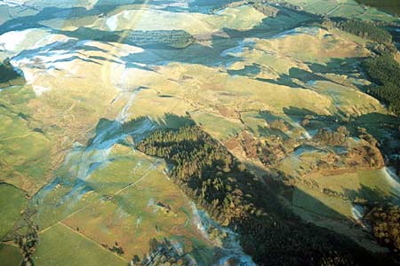
This is an area of mostly unenclosed and craggy upland with a height range of 270m - 450m. On the lower slopes improved grazing prevails, giving way to rough grazing and bracken on higher ground. Peaty and rushy hollows are common. Earth banks were the main boundary type, and still are in use on some of the lower slopes where they are supplemented by wire fences. Some derelict hedges are also present here. On higher slopes the ground is essentially unenclosed in character, though divided by wire fences. Apart from 20th century forestry this is essentially a treeless landscape. Evidence of mining consists of spoil heaps, levels and shafts, mostly at the extreme east of the area.
The recorded archaeology of this area comprises mostly post-Medieval sites. Metal mines and quarries are common features of the landscape, but more numerous are the deserted settlements. The distribution of these deserted settlements indicates a populated (albeit somewhat sparsely) area through to the 19th century. A possible monastic establishment - Bwlch-yr-Oerfa - and a possible Bronze Age standing stone, provide time-depth to the landscape.
This is a well-defined area. To the south lies the Ystwyth valley and the much afforested area of the Hafod estate. Modern forestry borders the area to the east. To the north is the village of Devil’s Bridge (Pontarfynach), and the lower-lying squatter settlement of Rhos-y-gell lies to the west.
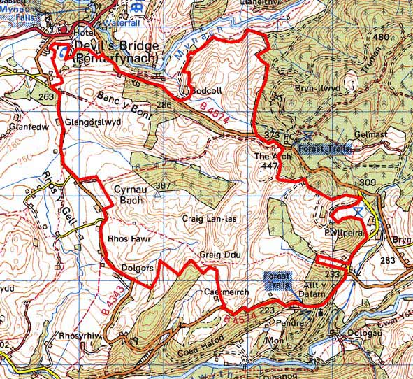
Base map reproduced from the OS map with the permission
of Ordnance Survey on behalf of The Controller of Her Majesty's Stationery
Office, © Crown Copyright 2001.
All rights reserved. Unauthorised reproduction infringes Crown Copyright
and may lead to prosecution or civil proceedings. Licence Number: GD272221