Home > Historic Landscape Characterisation > Upland Ceredigion > |

 BLAENAUCARON
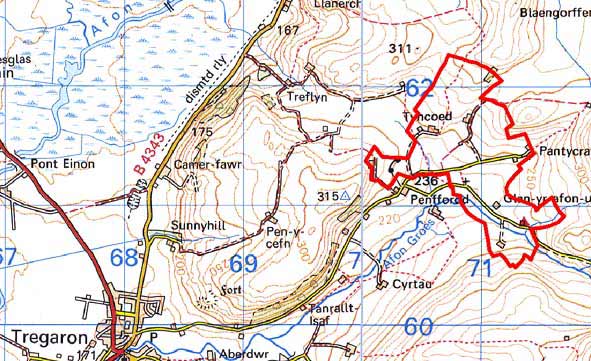
GRID REFERENCE: SN 708613
AREA IN HECTARES: 113.2
Historic Background
The early history of this area is unclear. It may have formed part of one of the granges of Strata Florida Abbey, or part of the demesne of the abbey. The granges were granted to the Earl of Essex on the Dissolution, who sold them to the Crosswood estate in 1630. In the late 18th century some land in this area was in the possession of Crosswood, and may have been obtained by this route. However, John Stedman acquired the Abbey demesne in 1567. Richard Stedman died intestate in 1746 and the estate passed to the Powells of Nanteos. Nanteos had considerable holdings here in the 19th century. It is likely that by the end of the Medieval Period, if not earlier, abbey granges and demesne were divided into farms that were leased out on a commercial basis. This may have been the origin of the settlement pattern we see today. The Caron Tithe map of 1845 shows this area much as it is today (Caron Tithe Map and Apportionment). 1819 estate maps (NLW Nanteos 180, 186: NLW Vol 45, 68) of the Blaenaucaron area, however, show higher farms to the northeast, such as Pantycraf and Fron-Felen, as isolated settlements set in a cluster of small irregular enclosures amongst open sheep-walk. Clearly, there was considerable enclosure between 1819 and 1845. In 1819, farms on lower levels such as Glanyrafon had been consolidated and enclosed, and appeared then much as they do today. This pattern of enclosure in the 19th century can be matched in other marginal areas of Ceredigion and is related to an increase in population. By the late 19th century population had achieved a level sufficient to build a chapel (Percival 1998, 520).
Description and essential historic landscape components
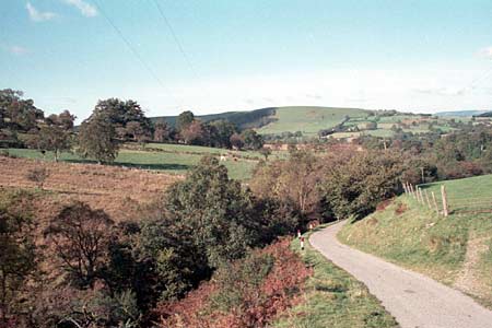
Blaenaucaron is a landscape of small- to medium-sized irregular enclosures and dispersed farms between 240m and 300m on the valley floor, and lower valley sides of the Afon Groes and tributary streams. At lower levels at the western end of the area field boundaries consist of earth banks and hedges, with some stone-faced banks and hedges. The earth banks generally give way to stone-faced banks and occasional dry-stone walls to the east and on higher ground. Hedges are in fair to good condition on lower ground, but are in poor condition and becoming derelict at higher levels, and in some instances they have been replaced with wire fences. Improved pasture predominates in the area, with patches of unimproved ground and rough grazing.
Local stone is the traditional building material with slate (north Wales slate) used for roofs. On houses walls are generally cement rendered, but some are left bare. Walls are always bare on traditional, 19th century farm buildings. Older farmhouses/houses generally date to the mid-to-late 19th century, are relatively small, of two storeys and in the typical Georgian vernacular style –gable end chimneys, central front door, two windows either side of the door and one above. Vernacular traits such as low eaves, small windows and one chimney larger than the other are present on some houses. Stone-built outbuildings are generally confined to one or two small ranges. Working farms have small ranges of modern steel and concrete agricultural buildings. A 19th century chapel and school are included in this area.
Recorded archaeology comprises some of the buildings mentioned above.
To the southwest and southeast this area gradually merges
with its neighbouring areas. To the north there is a fairly distinct boundary
with an area of large enclosures and unenclosed land.
Base map reproduced from the OS map with the permission
of Ordnance Survey on behalf of The Controller of Her Majesty's Stationery
Office, © Crown Copyright 2001.
All rights reserved. Unauthorised reproduction infringes Crown Copyright
and may lead to prosecution or civil proceedings. Licence Number: GD272221