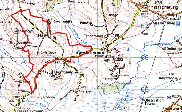
Home > Historic Landscape Characterisation > Upland Ceredigion > |

 BERTHDDU
GRID REFERENCE: SN 675662
AREA IN HECTARES: 216.5
Historic Background
In the Medieval Period part of this area lay within Strata Florida Abbey’s Mefenydd Grange. At the dissolution all Strata Florida’s holdings were granted to the Earl of Essex. Soon after, the land in and around this area seems to have been purchased by the Lloyds of Ffosybleiddiaid, and may later have been acquired by the Vaughans of Crosswood. The origin of this landscape is not known. The regular field system suggests enclosure in a single or few episodes, rather than irregular encroachment. The date of enclosure is unknown, but it and the settlement pattern had been established by the tithe survey of 1844 (Lledrod Tithe Map and Apportionment, 1844). A chapel was constucted in this area in the 19th century.
Description and essential historic landscape components
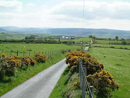
A southeast to northwest aligned ridge that achieves a maximum height of 270m. Its northeastern and southwestern flanks fall away rapidly to a low of 170m. This is an area of scattered farms and small- to medium-sized fairly regular enclosures; the larger enclosures generally located on the higher ground. The regularity of the enclosures is in contrast with the irregular field systems of areas to the east. Field boundaries consist of earth banks topped with hedges on the lower slopes, and stone-faced banks with mostly derelict hedges on the higher ground and ridge crest. Wire fences supplement many of the old boundaries. This is an open landscape with very few trees. Improved grazing is universal. Houses are of rendered stone with commercial slate roofs and in the typical mid-to-late 19th century Georgian vernacular style of the region, of two storeys with gable end chimneys, central front door, two windows either side of the door and one above. Vernacular traits such as low eaves, small windows and one chimney larger than the other are present on some houses. Stone-built outbuildings are of bare stone and generally confined to one or two small ranges. Working farms have small to medium sized ranges of modern agricultural buildings.
Recorded archaeology is not particularly varied, and consists mostly of post-Medieval extant or abandoned buildings, with the only time-depth element to the landscape provided by a Bronze Age burnt mound or hearth.
Landscape character areas to the north, east and west
have yet to be defined. To the south and southeast are the irregular enclosures
of neighbouring areas, though there is no clear division between these
and this area.
Base map reproduced from the OS map with the permission
of Ordnance Survey on behalf of The Controller of Her Majesty's Stationery
Office, © Crown Copyright 2001.
All rights reserved. Unauthorised reproduction infringes Crown Copyright
and may lead to prosecution or civil proceedings. Licence Number: GD272221