Home > Historic Landscape Characterisation > Upland Ceredigion > |

 BANC CREIGNANT MAWR
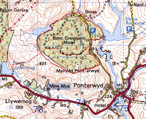
GRID REFERENCE: SN 737802
AREA IN HECTARES: 140.2
Historic Background
In the Medieval Period this area formed part of Cwm-hir Abbey’s Nantyrarian Grange (Williams 1990, 40). Following the Dissolution, its upland character probably ensured that the Crown claimed it, but by the late 18th century it had been appropriated, or otherwise acquired, by the Gogerddan estate. A late 18th century estate map shows it unenclosed (NLW Vol 37, 51) with no settlements, and this was how it remained until purchased by the Forestry Commission who planted it with conifers in the 1960s. Small-scale mining took place in this area - Bog metal mine was opened in 1830 and was worked through to 1882, although it was that successful an operation.
Description and essential historic landscape components
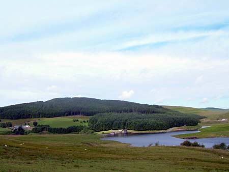
This area is completely covered by a hard-edged forestry plantation and comprises craggy upland, with a height range of 300 to 380m. Metal mining remains within the forestry consist of tips, shafts, building remains and leats. However, plantations, tracks, roads and other forestry features are the most common and prominent historic landscape components in this area.
In addition to the metal mining remains, recorded archaeology includes two possible Bronze Age round barrows.
This is a well-defined forestry block with unenclosed upland to the north, west and south, and lower lying enclosed, semi-enclosed and settled land to the east.
Base map reproduced from the OS map with the permission
of Ordnance Survey on behalf of The Controller of Her Majesty's Stationery
Office, © Crown Copyright 2001.
All rights reserved. Unauthorised reproduction infringes Crown Copyright
and may lead to prosecution or civil proceedings. Licence Number: GD272221