Home > Historic Landscape Characterisation > Upland Ceredigion > |

 AFON LERI
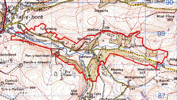
GRID REFERENCE: SN 682883
AREA IN HECTARES: 354.0
Historic Background
The history of this area has not been researched. Unlike many similar valley-floor historic landscape areas to the south, the Leri valley does not lie within one of the many granges of Strata Florida or Cwm-hir Abbey. In the post-Medieval Period no single estate dominated this area, unlike most of upland Ceredigion, and therefore there are no collections of large-scale 18th century maps with which to evaluate the development of the historic landscape. The tenurial system is likely to have been one of small owner-occupiers and small private estates, with a settlement pattern of dispersed farms. It is likely that the settlement pattern dates to at least the later Middle Ages, and may be earlier. The associated field system may be of a similar date. Superimposed over the agricultural landscape are the results of metal ore mining. These mines were small-scale operations, but nevertheless had sufficient impact on population levels for a schoolroom to be built in 1845 and a chapel in 1850 (Percival 1998, 512). The tithe map of 1845 shows a landscape essentially the same as that seen today.
Description and essential historic landscape components
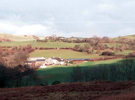
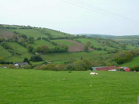
This area, which encompasses the floor and lower slopes of the Afon Leri, is both varied and complex. The Leri runs rapidly through this area, falling from 170m in the east to less than 90m in the west. Valley sides included in the study area rise steeply to over 200m, and beyond the study area they continue to rise across unenclosed land to over 300m. The settlement pattern of dispersed farms/houses is set in a field system of small- and medium-sized irregular enclosures. These enclosures are bounded by earth, or earth and stone banks topped with hedges, or by dry-stone walls. Dry-stone walls are in varying degrees of repair. Hedges are on the whole overgrown and no longer stock-proof; many contain distinctive trees. These trees together with the numerous stands of deciduous woods and conifer plantations lend a highly wooded appearance to the landscape. Farmland is of improved grazing with some rougher ground on steep slopes, and rushy patches in hollows. The tips and workings of several metal mines are a distinctive feature of the landscape. The course of the short-lived Plynlimon and Hafan tramway that served some of these mines passes through this area. Dams and leats at the western end of the Leri were built to serve the flannel industry in Tal-y-bont.
Older farms/houses date mainly to the mid-to-late 19th century and are built of local stone with commercial slate roofs. Many houses are cement rendered, some are painted stone and a few are bare stone, some with brick detailing. They are of two storeys and in the typical Georgian vernacular style –gable end chimneys, central front door, two windows either side of the door and one above. Vernacular traits such as low eaves, an asymmetrical floor plan, small windows and one chimney larger than the other are present on some houses. Some have been modernised and/or rebuilt. At least one single storey cottage –listed, with a crogloft – indicates a more vernacular tradition in this area than is represented by the two storey houses. Stone-built, 19th century farm outbuildings are generally confined to one or two small ranges. Working farms usually have one or two relatively small modern steel and concrete agricultural buildings, with larger farms having extensive ranges. There is also a scatter of modern houses and bungalows across the landscape.
Recorded archaeology mostly comprises the remains of metal mines. A mill and an extant chapel are also on the record. A limited time-depth element to the landscape is provided by a possible site of a Bronze Age standing stone, and by a Bronze Age burnt mound or hearth.
This is a relatively well-defined and distinct area.
To the north high, unenclosed land has yet to be described. To the south,
high, unenclosed land forms a clear border to this area. Elsewhere the
border is less distinct as neighbouring areas share many similar landscape
components.
Base map reproduced from the OS map with the permission
of Ordnance Survey on behalf of The Controller of Her Majesty's Stationery
Office, © Crown Copyright 2001.
All rights reserved. Unauthorised reproduction infringes Crown Copyright
and may lead to prosecution or civil proceedings. Licence Number: GD272221