Home > Historic Landscape Characterisation > Stackpole Warren > |

 STACKPOLE WARREN
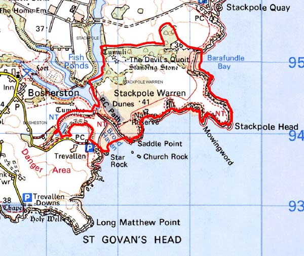
GRID REFERENCE: SR983947
AREA IN HECTARES: 197
Historic Background
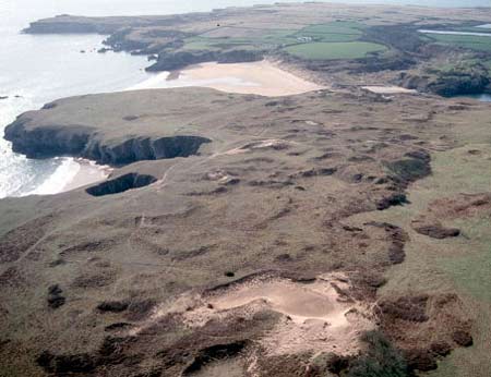
A small coastal area of modern Pembrokeshire, largely lying within the parish of Stackpole Elidor which, during the medieval period, was a manor comprising 4-5 knights fees held of the Lordship and Earldom of Pembroke, a heavily Anglicised region that was brought under Anglo-Norman control before 1100, re-organised along English manorial lines and never retaken by the Welsh. The name Stackpole may be of Scandinavian origin, derived from ‘stack’ or rock, indicating that the area was known – and perhaps even settled – by Norse seafarers during the later early medieval period. The name is shared with neighbouring Bosherston, which was originally called Stackpole Bosher. This character area is a level plateau, half of which is covered with calcareous blown sand. The sand dunes have enhanced the preservation of prehistoric sites and landscapes. Archaeological investigations have shown that this area was settled, divided into fields and cultivated in the prehistoric period. However, wind-blown sand, which began to accumulate in the prehistoric period, eventually created an environment unsuitable for cultivation and led to the abandonment of settlements and fields. In the medieval period this area was part of the Stackpole demesne (later the Stackpole estate), and documentary records show that it was a distinctive landscape used as a rabbit warren. During the two World Wars it was used as a military training area. It is now owned and managed by the National Trust.
Description and essential historic landscape components
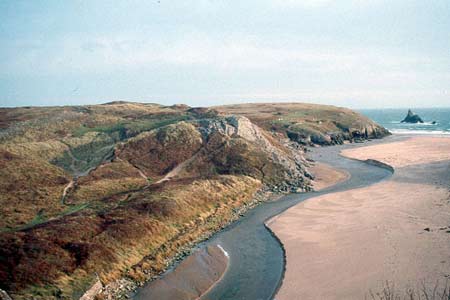
The relatively small registered area of the Stackpole Warren Landscape of Special Historic Interest in Wales is almost entirely occupied by this historic landscape character area. It consists of a coastal plateau lying between 30m and 35m bounded to the south and east by vertical limestone sea cliffs, to the west by an artificially flooded valley – part of the Stackpole Court gardens – , and by Stackpole Park to the north. It is an unenclosed landscape of wind-blown calcareous sand covering limestone bedrock. The sand varies in thickness from a relatively thin skin to developed dune systems. Limestone bedrock protrudes through the sand at many locations, but particularly along the coast. Vegetation consists of pasture and bracken on the plateau with some sycamore dominated woodland on its more sheltered flanks. The sand, which began to form in the prehistoric period, has been instrumental in preserving a rich and varied prehistoric landscape. It is this prehistoric landscape that merits its inclusion on the Register. Excavation and survey in the 1970s revealed occupation from the Mesolithic Period through to the Romano-British Period and beyond, with the sand both preserving and separating the many phases of archaeological horizon. Sites include the Devil’s Quoit standing stone, settlements and extensive field systems, and the excellent preservation by the sand has enabled the identification of prehistoric plough marks and cattle hoof imprints. Several of the archaeological sites are Scheduled Ancient Monuments. There are no buildings, and wire fences are the only boundaries currently used. The Pembrokeshire Coast Path runs along the cliff top.
This is a very well defined character area, and contrasts with the parkland landscape to the west and north. It is defined by high sea cliffs to the south and east.
Sources: Benson et al 1990; Cadw 2001; Higgins 1933;
Howells 1964; Owen 1918; Walker 1950
Base map reproduced from the OS map with the permission
of Ordnance Survey on behalf of The Controller of Her Majesty's Stationery
Office, © Crown Copyright 2001.
All rights reserved. Unauthorised reproduction infringes Crown Copyright
and may lead to prosecution or civil proceedings. Licence Number: GD272221