Home > Historic Landscape Characterisation > Stackpole Warren > |

 STACKPOLE COURT PARK AND GARDENS
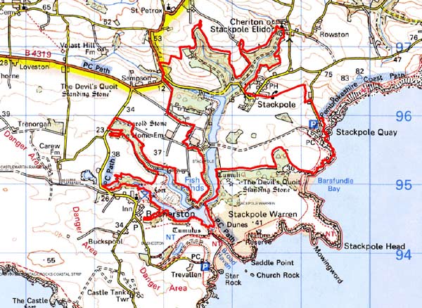
GRID REFERENCE: SR 975953
AREA IN HECTARES: 367
Historic Background
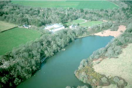
A small area of modern Pembrokeshire comprising Stackpole Court park and gardens. This character area lies within the parish of Stackpole Elidor which, during the medieval period, was a manor comprising 4-5 knights fees held of the Lordship and Earldom of Pembroke, a heavily Anglicised region that was brought under Anglo-Norman control before 1100, re-organised along English manorial lines and never retaken by the Welsh. The name Stackpole may be of Scandinavian origin, derived from ‘stack’ or rock, indicating that the area was known – and perhaps even settled – by Norse seafarers during the early medieval period. The name is shared by neighbouring Bosherston, which was originally called Stackpole Bosher. The ‘Elidor’ suffix – first used in c.1200 and also seen in the joint dedication of Stackpole parish church – could derive from the personal name of an individual mentioned by Giraldus Cambrensis, as ‘Elidyr of Stackpole’, thought by some authors to be an early lord. However, the name occurs in association with a semi-fictional parable. And while it is interesting that a ‘William son of Elidur’ granted an unidentified area of land to Slebech Commandery, in all likelihood the ‘Elidor’ element, and the dedication, are derived from ‘Eliud’, a hypocoristic form of St Teilo’s name. Philip de Stackpole was recorded as being possessed of 4 knight’s fees in 1247, while Richard de Stackpole held 5 fees at Stackpole in 1324. Their residence may have been fortified - the name ‘Stackpole’ appears in a list of 19 ‘ancient castles’ in Pembrokeshire, compiled by George Owen in 1599. However, there is no indication of what form this ‘ancient castle’ took, or whether it occupied the site of the later mansion. The church, with its Teilo dedication, may be a pre-Conquest foundation. It lies in a nucleation, Cheriton, 700m north of the village of Stackpole itself, which appears to have been a secondary nucleation established around a cross-roads during the post-Conquest period. It appears to have been primarily and agricultural vill, but the presence of a medieval village cross suggests that a market or fair was held in the village, and indeed Rees’ 1932 map shows the it as the site of a possible fair. The estate passed through an heiress from the Stackpole family to the Vernon family of Haddon Hall, Derbyshire. George Lort, the Stackpole family steward, was left in charge of Stackpole. By the mid 16th century Lort had purchased the estate from the Vernons. In 1698, the estate passed to Elizabeth Lort, who married St Alexander Campbell of Cawdor. She died in 1714, and thus the estate passed to the Campbells. The Campbells transformed the house, gardens and estate. An engraving of 1758 shows a massive square house. By 1782 lakes had been formed by throwing dams across the valleys below the house, and pleasure gardens, a walled garden and New Deer Park were created, in addition to the Old Deer Park. The southern half of Stackpole village was removed during the construction of this new park, leaving the medieval village cross stranded within parkland. Summerhouses and grottos were also built, and at its height Stackpole rivalled the best gardens in Britain. Enlargements and improvements were made to the mansion and associated buildings by Sir John Wyattville, the King’s architect, and Henry Ashton in the 1820s. Stackpole became one of the great estates of south Wales, covering over 17,700 acres by 1900. In 1962, the contents of the house were sold and the property demolished soon after. The National Trust now own most of the gardens and parkland.
Description and essential historic landscape components
Stackpole Court Park and Gardens historic landscape
character area is virtually coterminous with the park and garden included
in the Register of Parks and Gardens for Carmarthenshire, Ceredigion and
Pembrokeshire. The Register contains a full description of the site. This
is an estate landscape and comprises several narrow valleys that converge
at the coast at Broad Haven, and pockets of level ground above the valleys
at about 30m – 35m above sea level. The whole has been landscaped
into parks and gardens: the valleys dammed to create lakes and the level
ground moulded into parkland and gardens. At the core of this area are
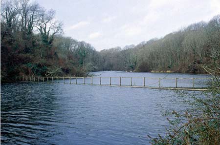
several interlocking, long narrow ornamental lakes or lily ponds, the
longest arm of which runs inland from Broad Haven for over 2km. Paths
and tracks link several stone bridges or causeways that cross the lakes.
These paths are much frequented by tourists. Deciduous woodland cloaks
the steep valley sides above the lakes. Stackpole Park, characterised
by pasture divided by wire fences, clumps of trees and shelterbelts lies
to the east of the area. To the north most of the old park is heavily
wooded with some open pasture. The ornamental gardens and pleasure grounds
lay to the west of Stackpole Court mansion, which was demolished in the
1960s. The pleasure grounds are now heavily wooded. The built aspects
are overwhelmingly estate dominated and date mainly to the late 18th and
19th centuries. They range include the bridges and causeways already mentioned,
as well as a walled garden, a gardener’s cottage, a stable block,
service buildings to the south of the old mansion, summerhouses and grottos.
The large Georgian farmhouse of the Home Farm with its very extensive
range of formally arranged, limestone-built farm buildings (converted
to offices, workshops and a residential centre) are included in this area,
as are Stackpole
Quay and the nearby early 19th century estate farm and fine range of outbuildings
set around a courtyard (converted to holiday accommodation). Many of these
buildings and structures are listed. Mortared limestone walls are the
main boundary type - a clear estate signature - but occasional dry-stone
walls and boundary banks are present. Most recorded archaeology is associated
with the estate, park and gardens, such as the fine limekiln at Stackpole
Quay. Also recorded are numerous limestone quarries and a hillfort, known
as Fishpond Camp, on a spur between the lakes.
Stackpole Court is a very distinctive and important parkland landscape. It contrasts with the adjoining agricultural landscapes to the north, east and west and with the blown-sand of Stackpole Warren to the south.
Sources: Bosherston Parish tithe map 1839; Cadw 2002;
Davies 1946; Lloyd 1989; NLW Vol 87 1782; NMR Cawdor Map Book 1787; Owen
1897; Owen 1918; Rees 1932; Stackpole Elidor parish tithe map 1839 ; St
Petrox parish tithe map 1839; Thorpe 1978; Walker 1950
Base map reproduced from the OS map with the permission
of Ordnance Survey on behalf of The Controller of Her Majesty's Stationery
Office, © Crown Copyright 2001.
All rights reserved. Unauthorised reproduction infringes Crown Copyright
and may lead to prosecution or civil proceedings. Licence Number: GD272221