|

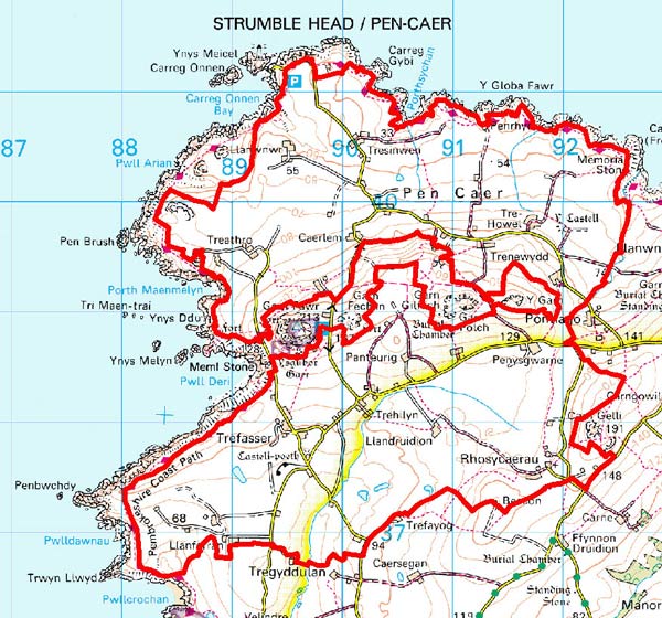
 PEN CAER
GRID REFERENCE: SM 903389
AREA IN HECTARES: 1274
Historic Background
A large area of modern Pembrokeshire comprising most of the Pen Caer/Strumble Head peninsula except for the coastal strip, mainly within Llanwnda parish but also including part of St Nicholas parish. During the medieval period the area formed part of the medieval Cantref Pebidiog, which was conterminous with the later Hundred of Dewsland created in 1536. It was held directly by the Bishops of St David’s, having represented the core of the bishopric from 1082 when it was granted (or confirmed) by Rhys ap Tewdwr, king of pre-Anglo-Norman Conquest Dyfed, to Bishop Sulien. The area has a long and complex history of settlement, much of it associated with medieval Christianity. However, the present landscape may have earlier origins as boundaries of possible prehistoric date are preserved in the adjoining Garn Fawr character area. The fields immediately northwest of Garn Fawr, around Tal-y-gaer Farm, for example, appear to perpetuate this prehistoric system. From 1115 onwards, when Bernard was appointed Bishop of St David’s, Anglo-Norman systems of feudal government and ecclesiastical administration were introduced into Pebidiog and the majority of the Pen Caer character area occupied Villa Grandi, which was referred to as a manor in 1326 but possibly not in the formal, Anglo-Norman sense. Welsh tenurial systems appear moreover to have persisted, although variously adapted, while many feudal rights and obligations continued into the early 20th-century. Pebidiog was subject to a detailed survey in 1326, when the present farms of Castell, Tre-fisheg and Tresinwen were recorded. They appear to have constituted loose townships rather than Anglo-Norman vills and none of them today comprise proper nucleations. The township of ‘Castell Wladus’ may represent the site of the motte-and-bailey at Castell Poeth, whose history is unknown but is likely to have been short-lived, with little influence on the development of the area. A township at ‘Llandogen’ appears to have been established around the site, now lost, of Capel Degan, which probably had early medieval origins. Another early medieval chapel site may have been at Llandruidion where a field named Hen Fynwent revealed cist graves. It was also the site of a vill during the medieval period and lay within the ‘manor’ of Villa Camerarii. The boundary between Villa Camerarii and Villa Grandi was coterminous with - but may predate - the parish boundary now represented by a continuous field boundary and an unclassified road. Other present holdings, held ‘by the law of Wales’ in the 1326 survey, include Trefasser (by unfounded tradition the birthplace of Alfred the Great’s advisor Asser), Llanwnnwr (also the site of an early chapel) Panteurig, Penysgwarne, Treathro and Tresinwen. A system of longish, north-south strip fields in the northern half of the area is not typical of medieval, Anglo-Norman strip-fields but may have originated from strips held under native systems of Welsh tenure. The majority of enclosures within the area appears later, comprising regular fields with straight boundaries, and it may be that the underlying landscape was open field or common during the medieval period. The farm names ‘Goodhope’, ‘Harmony’ (close to a Baptist Chapel founded in 1828) and ‘Tai-bach’ indicate new post-medieval settlement, as may the gentry-house at Trehowel which has no recorded history earlier than 1603. Apart from the tithe map of 1845, which shows a landscape virtually identical to that of today, there are no historic maps for this area. However, a 1849 estate map of Velindre, which lies to the south of this landscape, shows a field system of intermixed strips, both unenclosed and enclosed. It is possible that open fields formerly lay across much of the Pen Caer landscape, but had been engrossed and enclosed by the time of the tithe survey.
Description and essential historic landscape components
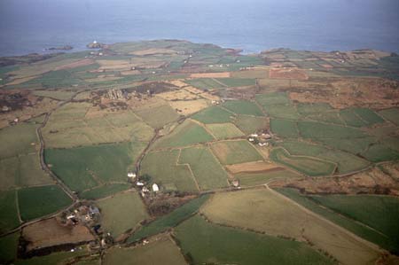
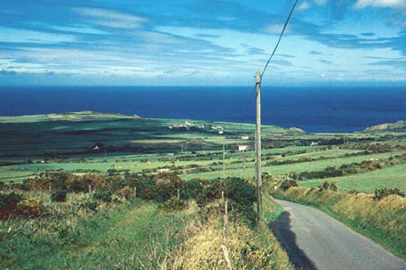
Pen Caer is a large and complex historic landscape character area occupying the western part of the Pen Caer/Strumble Head peninsula to the south and north of the high moorland of Garn Fawr. To the north of Garn Fawr this is a plateau at c. 60m – 70m bounded by sea cliffs. To the south of Garn Fawr this area lies on gently sloping, south-facing land. The historic landscape consists of dispersed farms set in a landscape of small- and medium-sized irregular fields. Trefasser with its loose cluster of farms, houses and cottages is the only settlement nucleation in the area, and this is very small. Field boundaries are a mixture of dry-stone walls and stony banks. Most boundaries are well maintained, although some of the dry-stone walls have deteriorated and are no longer stock-proof. Generally, walls are more common closer to the coast and on the margins of the high moorland of Garn Fawr, with banks dominant elsewhere. The majority of the banks are made from roughly coursed stone and earth. Foundation stones in some banks are massive, and the banks themselves are, in most instances, very large. Stony banks and low walls radiate out from the hillforts on Garn Fawr on to the lower lying land of this area and are perpetuated in the modern field boundaries; these are clearly prehistoric in origin and attest to the ancient enclosure pattern of at least part of this landscape. It is a very exposed landscape, open to almost constant buffeting from westerly winds. Consequently hedges where present on the banks are low and windswept, and trees, apart from scrubby woodland in sheltered hollows and close to houses, are absent. Agricultural land-use is almost entirely improved pasture, with a little arable land and a few pockets of rough grazing. Almost the entire building stock of this area consists of dispersed farms, houses and cottages. There is very little that dates to before the early 19th century. An exception is the 18th century vernacular house at Trehowell with its slate-hung elevations. Stone is the universal building material. This is roughly coursed and left bare or cement rendered and colour washed. Occasional as at Trehowell it is slate-hung. There are no major dwellings in the area, and most farmhouses and other houses are of two-storeys and three bays with a central front door and gable chimneys. Examples in both the vernacular tradition dating mainly to the early 19th century, and the ‘Georgian’ style of the mid- and late-19th century are present. The numerous single-storey vernacular cottages of three bays and a central front door are a distinctive element of this area. Several are listed. They are concentrated on the fringes of marginal land, suggesting that they originated as squatter settlements, and include Garn Fawr and Studio Cottage occupied by the artist John Piper. Old farm buildings are of bare stone. Most are quite small and consist of barn, cow house and cart shed compressed into one or two ranges, but larger examples are present, such as at Trefasser Isaf, Trehowell and Penysgwarne. In some of these examples the farm buildings and yard are situated a little distant from the dwelling, indicating a house elevated a rung or two up the social scale than the more common farmhouses of the area. Unusually several ranges of larger outbuildings are listed – those at Trefasser, Penysgwarne and Trehowell for example – and more unusually still some smaller farm buildings are also listed as at Pontiago and close to Harmony. Slate is the traditional roofing material for houses and farm outbuildings. The cement skim or mortar grouting applied to slate roofs can be seen on both houses and farm buildings and is a distinctive characteristic of the exposed, western fringes of this part of Pembrokeshire. Asbestos sheet has replaced slate on numerous old farm buildings. Modern agricultural buildings of concrete, steel and asbestos are larger and a more prominent landscape feature on farms to the north of Garn Fawr than on those to the south. There are only a few modern houses in this area, and the only substantial non-domestic/non-agricultural building is the 19th century stone-built chapel at Harmony. Archaeological sites are numerous and varied and testify to a settled landscape over several millennia. Several prehistoric flint-working sites lie close to the coast. Other prehistoric sites include one standing stone and several possible standing stones of bronze age date, a round barrow and a possible chambered tomb. There are three iron age forts in the area, including one scheduled example. The importance of the area in the early medieval period is demonstrated by the presence of three inscribed stones, three possible chapels and a holy well site. For the medieval period, one (or two) earthwork castles, both scheduled, are recorded as well as several settlement sites. Stone quarries are present in later periods.
To the north and west this area is well defined by the coastal slope and high sea cliffs. To the east this area merges with that of Llanwnda, which shares many similar historic landscape components. To the south the historic landscape character area has yet to be described, but here such components that characterise Pen Caer such as the dry-stone field boundaries and massive stone banks are less common, and hedges and small stands of woodland are more prominent.
Sources: Charles 1992; Jones 1996; Llanwnda Parish
tithe map 1845; Ludlow 2002; National Library of Wales 14229/6; Pembrokeshire
Record Office D/JP/193, HDX/57/30; Ress 1932; Willis-Bund 1902
Base map reproduced from the OS map with the permission
of Ordnance Survey on behalf of The Controller of Her Majesty's Stationery
Office, © Crown Copyright 2001.
All rights reserved. Unauthorised reproduction infringes Crown Copyright
and may lead to prosecution or civil proceedings. Licence Number: GD272221