|

 GOODWICK
GRID REFERENCE: SM 943382
AREA IN HECTARES: 113
Historic Background
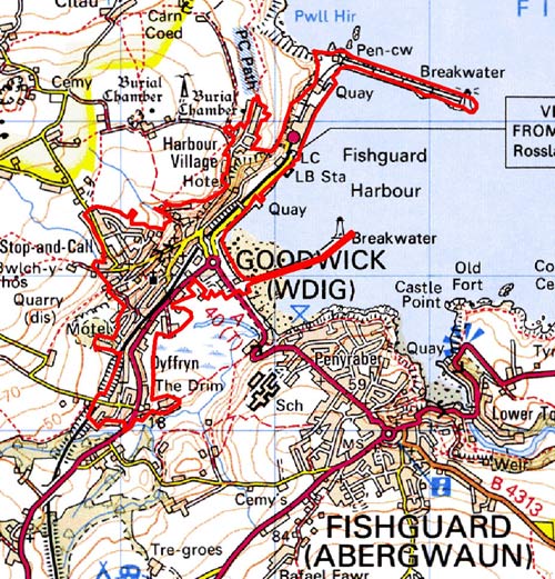
A narrow strip of land in modern Pembrokeshire, to the west side of Fishguard Harbour, Goodwick Brook and Goodwick Moor. The area is now largely built over by the town of Goodwick, whose development is almost entirely a product of the 19th century and 20th century. There is little recorded earlier settlement; it lay outside the medieval and later borough of Fishguard. The northern end of the area, now occupied by the Goodwick Ferry Terminal and associated development, lies largely upon made ground laid down in 1906 to connect the terminal with a large breakwater. Historically the headland on which the breakwater was constructed, Pen-cw Point, more-or-less formed an island. However, a ?neolithic hammer-stone found on the slope above Pen-cw Point, a possible flintworking floor, a possible round barrow and an important early medieval penannular brooch retrieved from Goodwick Sands all indicate an earlier human presence, if not settlement. The area, moreover, had been named ‘Pwllgwdig’ as early as 1074 when it was the scene of a battle between warring Welsh Princes, the site of which has been tentatively identified as Goodwick Moor. During the later medieval period, the area formed part of the medieval Cantref Pebidiog, or ‘Dewisland’, which was held directly by the Bishops of St David’s, having represented the core of the bishopric from 1082 when it was granted (or confirmed) by Rhys ap Tewdwr, king of pre-Anglo-Norman Conquest Dyfed, to Bishop Sulien. Pwll-hir Common, over which part of the town is built, may have medieval origins but has no recorded early history. The raised saltmarshes of Goodwick Moor, a small part of which lie within this area, exhibit a number of physical features associated with land-reclamation, including the ?early post-medieval canalisation of Goodwick Brook and several earthworks. The Bishops of St David’s who owned saltmarsh meadows here until the 20th century may have undertaken some drainage works. The small nucleated hamlet at Dyffryn, which lay on an island of enclosed land in saltmarsh, appears to have developed from a gentry-house, Dyffryn Goodwick. The house, which may be mentioned in a deed of 1595, was certainly present in 1624 and the site still remains. To the north a gentry-house – Goodwick House - had been constructed on part of Pwll-hir Common overlooking the harbour, prior to 1702. A quay had also been constructed on the site of the harbour breakwater (shown on a map of 1815). The tithe map of 1845 shows three distinct elements of what was to become Goodwick – the quay with a small settlement, a small nucleation of houses at the crossroads on the foreshore, and Dyffryn hamlet. In fact the development of the area did not really begin until 1906 when the ferry terminal, and railway link from Haverfordwest, were opened by the Great Western Railway, the Fishguard and Rosslare Railway, and the City of Cork Steam Packet. The railway, breakwater and new port facilities are all depicted on the OS map of 1908 and many of the present structures retain substantial elements from these original buildings, particularly the railway station, the engine sheds and old customs house. Goodwich House was purchased by the GWR and rebuilt as the Fishguard Bay Hotel. The map shows that Dyffryn was by now linked to the main settlement at Goodwick by the railway, and new houses had to be constructed along the valley floor and up the steep valley side. The constraints of the site were already apparent, as terraces of new houses had been built on the flat ground high above the harbour. Development during the 20th century was sporadic. Housing development continued along the valley floor, linking Dyffryn with Goodwick proper, and up the steep valley side. In the last quarter of the 20th century commercial development has taken place on the marsh behind the foreshore, and considerable improvements to the port’s infrastructure have been carried out.
Description and essential historic landscape components
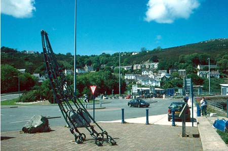
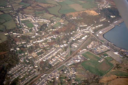
Goodwick is a small urban historic landscape character area located on a constrained site of steep southeast-facing valley side and a narrow valley bottom. Although it is a nucleated settlement, open spaces and woodland on the steep valley sides between the houses lend a rural aspect to parts of Goodwick. To its east lies the sea and a stretch of coastal marsh. Goodwick harbour and the railway are the core and raison d’ètre of the settlement. There are very few historic landscape components earlier than the 19th century, and most date to the mid-to-late 19th century and 20th century. The oldest portion of the area is at Dyffryn. Here there are some older stone-built structures, including Dyffryn House, a substantial stone-built house with 16th century elements, and a former watermill. From the commercial/industrial core at the harbour residential settlement spreads along the valley floor and up the valley side. The central, oldest, residential part of Goodwick is nucleated around a road intersection at the base of the valley side. Here shops, houses, public houses and chapels are mostly of mid-to-late 19th century date. There is considerable variety in building materials and styles. Materials range from red brick through to bare stone and cement rendered stone. Corrugated-iron sheeting protects the walls on some buildings. Included is a corrugated-iron hall – the former Goodwick Institute built in c. 1900. Stone buildings are generally earlier and include early 19th century cottages. The gothic style church of St Peter dates to 1910. Slate is the most common roofing material. Linear development of later 19th century terraced housing built as single units is situated on the valley floor, while on the constrained valley side more informal terraces, larger detached or semi detached housing has developed, again in a variety of styles and materials, but with many buildings displaying neo-gothic porches, windows and other details. During the 20th century small linear housing estates were built on the less steep higher slopes on the minor road up to Stop-and-Call and on the plateau above Goodwick Harbour, as well as along the main A487 road (now quite since it was bypassed by the Fishguard Eastern Bypass) to the southeast of the old residential core. The railway station on the quayside retains many of its early 20th century redbrick buildings. The former brick stationmaster’s house is on Station Hill. Nearby the Fishguard Bay Hotel dates to the late 19th century but was enlarged in 1905 by the Great Western Railway in the anticipation of trans-Atlantic passengers. The gardens of the hotel, laid out in the first decade of the 20th century are included in the Register of Parks and Gardens for Carmarthenshire, Ceredigion and Pembrokeshire. Several listed structures in Goodwick include public buildings and older cottages, but not the more typical late 19th century terraced and other houses. Much of the harbour and port facilities are of late 20th century date and include extensive infrastructure for the Irish car ferries. The main, north, breakwater, dating to the early 20th century is a prominent feature of this area; the less massive east breakwater less so. Petrol stations, light industry and leisure facilities developed in the late 20th century across reclaimed marsh and alongside the A40(T) road that runs along the sea front. Within this area are small pockets of steep coastal slope. Recorded archaeology mostly consists of 19th century and 20th century structures associated with the port and town, but a possible bronze age round barrow and a prehistoric flint working site lie in the area.
This is a very distinctive historic landscape character area and contrasts with neighbouring areas of farmland and marsh. It is separated from the older urban area of Fishguard by a stretch of marsh and foreshore.
Sources: Cadw 2002; Charles 1992; James 1981; Jones
1952; Jones 1996; Llanwnda Parish tithe map 1845; Ludlow 1994; Ordnance
Survey Pembrokeshire Sheet IV.SE, 1891 and 1908; RCAHMW 1925; Roberts
et al 1986
Base map reproduced from the OS map with the permission
of Ordnance Survey on behalf of The Controller of Her Majesty's Stationery
Office, © Crown Copyright 2001.
All rights reserved. Unauthorised reproduction infringes Crown Copyright
and may lead to prosecution or civil proceedings. Licence Number: GD272221