Home > Historic Landscape Characterisation > Newport and Carningli > |

 NEWPORT TO DINAS ISLAND COASTAL STRIP
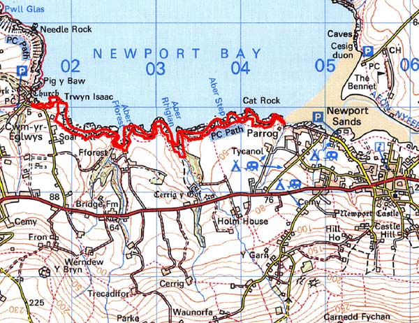
GRID REFERENCE: SN 019397
AREA IN HECTARES: 25
Historic Background
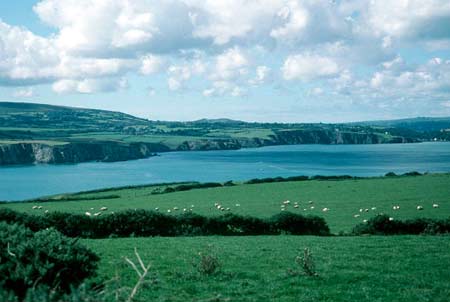
A character area of modern Pembrokeshire comprising a narrow coastal strip between Newport and Dinas Island. It lies within the medieval Cantref Cemaes. Cemaes was brought under Anglo-Norman control in c.1100 by the Fitzmartins who retained it, as the Barony of Cemaes, until 1326, when they were succeeded by the Audleys. The Barony was coterminous with the later Hundred of Cemais, which was created in 1536, but many feudal rights and obligations persisted, some until as late as 1922. Historically, this coastal strip has always been marginal land, lying between the boundaries of cultivated land and the sea-cliffs. There appear to be no occupation sites although the landscape is typical of iron age coastal promontory fort topography. Past land-use was mainly as rough grazing, and quarrying. Although there are only a few places suitable for landing small boats along this stretch of high sea cliff, chiefly the bays at Aber Forest and Aber Rhigian, quarrying has been undertaken on a fairly intensive scale since at least 1594 when the Extent of Cemaes recorded that ‘seaside quarries both of slate and hewings stones’. George Owen writing in about 1600 notes that these were a source of ‘tiling stone’. However, the presence of local stone roofing tiles from excavations in Newport indicates that quarries, perhaps these coastal ones, had been in use from at least the 13th century. Working carried on until the late 19th century at Chwarel Gerry, Chwarel Pwdwr, Fforest Farm and Parrog. Twentieth-century history includes the operation of a lifeboat out of Y Cwm.
Description and essential historic landscape components
This is a linear coastal historic landscape character area running from Cwm-yr-Eglwys in the west to The Parrog at Newport in the east, a distance of about 3km. It is very narrow, on occasions less than 20m wide, but averages about 50m, and comprises hard-rock sea cliffs, which achieve heights of over 50m at the western end, and a narrow band of rough ground sandwiched between the cliffs and farmland to the south. The Pembrokeshire Coast Path runs along the cliff tops. Apart from a lifeboat house at Y Cwm there are no buildings in this area. Recorded archaeology comprises several old slate quarries and associated structures such as landing places.
This is a very well defined historic landscape character area bounded by the sea to the north and enclosed farmland to the south.
Sources: Dinas Parish tithe map 1841; Howells 1977;
Murphy 1994; Newport Parish tithe map 1844; Richards 1998
Base map reproduced from the OS map with the permission
of Ordnance Survey on behalf of The Controller of Her Majesty's Stationery
Office, © Crown Copyright 2001.
All rights reserved. Unauthorised reproduction infringes Crown Copyright
and may lead to prosecution or civil proceedings. Licence Number: GD272221