Home > Historic Landscape Characterisation > Milford Haven Area > |

HERBRANDSTON 
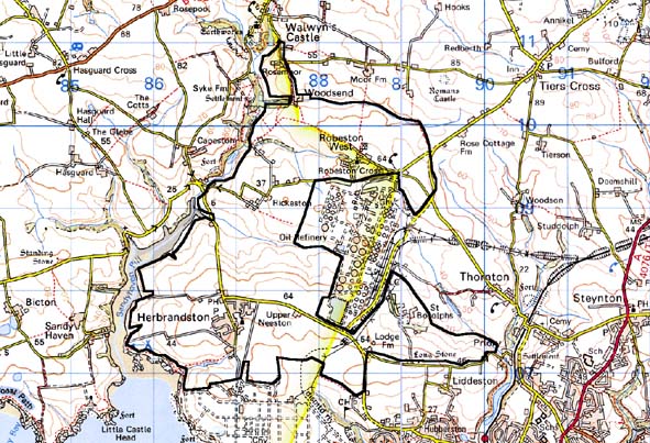
GRID REFERENCE: SM 866088
AREA IN HECTARES: 782
Historic Background
This character area is situated on the north shore of the Milford Haven
waterway, within the parishes of Herbrandston and Robeston West. Most
of the present farms and landholdings can be identified with medieval
manors, which were subject to a complex process of division and sub-infeudation
following the break-up of the Earldom of Pembroke in 1247. Most of Herbrandston
parish was a member of the medieval Barony of Walwyn’s Castle, which
comprised 2 ¾ carucates held of the barony ‘by homage’.
The settlement, the medieval ‘Villa Herberandi’, surrounds
the parish church that belonged to the Augustinian Haverfordwest Priory.
Robeston West is largely coterminous with the medieval Manor of Robeston,
a member of the Lordship of Haverford that was probably not established
until the 14th century; during the 16th century, it was held by the influential
Perrotts of Haroldston. The parish church is associated with the site
of the shrunken vill of Robeston. Rickeston comprised ¼ of a knight’s
fee, held directly of the Earls of Pembroke as their share of the lordship.
St Botolph’s lay within the Manor of Pill, whose lord granted it,
along with a tenement in Robeston, to the Tironian Pill Priory in the
mid 13th century. The chapel at St Botolph’s (St Budoc’s)
was a possession of the priory and appears to have had burial rights;
it may therefore be a pre-Angle-Norman Conquest foundation. These various
ownerships are not reflected in any differing tenurial arrangements, and
a homogenous pattern of enclosure existed. From the 18th century, when
the first large-scale maps were surveyed, the landscape history of this
area is similar to that of Hoaten – Hasguard to the west. These
maps show an agricultural landscape virtually identical to that of today.
Large farms often with gardens, orchards and parks had been established
and large regularly shaped fields laid out. The origin of this landscape
is uncertain, but many of the larger farms have medieval origins, possibly
as agricultural hamlets with open field systems. These open fields may
have been enclosed in the late medieval period or early modern period
and the hamlets transformed into large, single farms.
Base map reproduced from the OS map with the permission
of Ordnance Survey on behalf of The Controller of Her Majesty's Stationery
Office, © Crown Copyright 2001.
All rights reserved. Unauthorised reproduction infringes Crown Copyright
and may lead to prosecution or civil proceedings. Licence Number: GD272221
Description and essential historic landscape components
This historic landscape character area lies to the east of Sandy Haven
on a plateau, lying between 30m and 60m, which is dissected by several
small valleys. Apart from small stands of woodland in some of these valleys
and shelterbelts, and other planting close to houses it is a treeless
landscape. Land-use is a mixture of arable and improved pasture. There
is very little rough grazing or neglected land. The field pattern is one
of large enclosures. Earth banks topped by hedges bound these. Hedges
are generally well maintained, although a few examples are becoming overgrown
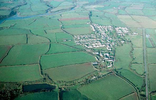
and gaps are appearing in others. Apart from the village of Herbrandston,
the settlement pattern is of dispersed farms. Farms are large, and indeed
the houses of several of them are, or were, mansions – Roberston
Hall, Rickerston Hall, St Botolphs and Herbrandston Hall - although smaller
dwellings are also present. Smaller farmhouses are generally late 18th
century or 19th century and stone-built, slate roofed, two storey, with
most examples in the Georgian tradition. A few dispersed 19th century
and 20th century dwellings are present. Substantial ranges of stone-built
outbuildings usually accompany the larger farms, often set around a courtyard.
Herbrandston Hall and St Botolophs have good examples of high quality
farm buildings, the latter including three grade II listed buildings.
Most farms also have collections of late 20th century outbuildings. In
general the smaller farms have less substantial old and modern outbuildings.
Herbrandston is a compact village. Its centre, focused on the medieval
church of St Mary, still retains something of its agricultural ancestry,
with 19th century two-story cement rendered houses and single storey cottages
– both in the vernacular tradition – set around a small green.
Twentieth century housing is also present here, with more substantial
development on the fringes of the village. A pub and school are also located
in the village. Other buildings in the area include the medieval church
of St James at Robeston West. Individual archaeological sites are not
a large component of the historic landscape. Nevertheless iron age hillforts,
a neolithic chambered tomb, bronze age burnt mounds and several find spots
of prehistoric artefacts lie in the area.
This area’s boundaries to the west against the tidal inlet of Sandy Haven and to the south against sea cliffs and an oil refinery are well defined. Part of the area’s eastern boundary where it runs alongside an oil refinery is also very well defined. However, to the north and the east definition is less good; here there is a zone of change, rather than a hard-edged boundary.
Sources: Herbrandston Parish tithe map 1839; Jones 1996; Ludlow 1998;
Ludlow 2002; NLW R K LUCAS COLL NO. 16; Owen 1918; PRO D/RKL/1194/1, 2,
6, 11, 12, 15, 16 & 18; PRO HPR//21/3; PRO D/RKL/932; Robeston West
Parish tithe map 1843