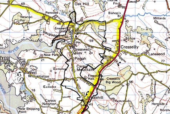
Home > Historic Landscape Characterisation > Milford Haven Area > |

CRESSWELL QUAY 
GRID REFERENCE: SN 052060
AREA IN HECTARES: 268
Historic Background
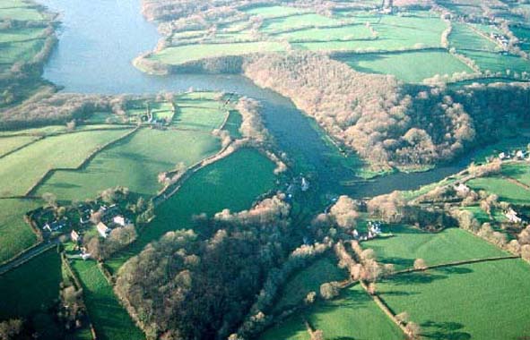
A small character area lying at the head of the Cresswell River, an inlet
from the middle reaches of the Eastern Cleddau. It lies within the parish
of Jeffreyston and extends into Carew and Lawrenny parishes, which occupied
the medieval Barony of Carew. However, the only early settlement known
in this area, Cresswell Castle, now a mock-fortified residence of the
late 16th- or early 17th-century, is not listed among John de Carew’s
estates in 1367. Neither does it appear among George Owen’s list
of manors in c.1600 and it has been suggested that the estate was held
by the Augustinian priory at Haverfordwest in the medieval period. The
Barlows of Slebech purchased it in 1553, and they built the present mansion.
A chapel stands detached from the main buidling. A wood was associated
with the mansion and was described by George Owen in c.1600 as ‘sufficient
to serve (for) fuel and some for buildings’. The estate remained
in Barlow hands until the mansion was abandoned in c.1800. Much of the
present landscape appears post-medieval in date and probably owes its
origins to settlement associated with the coal industry. This was intimately
associated with the quay at Cresswell and both have been crucial in defining
the present landscape of the area. Coal has been mined in this area since
the late medieval period. Between 1768 and 1828 over 50 small pits were
operating inland from the quay. Several of these pits are shown on Carew
Mountain and Whitehill on a 1777 estate map. Coal was loaded onto barges
at Cresswell and shipped down-river to Lawrenny where it was loaded onto
larger ships. Coal folds were constructed at the quay to store coal prior
to shipping. By the 1820s the industry was in decline, although the last
commercial use of the quay was in 1948 when a load of culm was landed
from Hook. Houses and cottages built for and by workers in the industry
produced a distinctive settlement pattern and vernacular architecture,
and a village developed at the quayside. New settlements emerged at Pisgah,
around a nonconformist chapel, and at Whitehill. A map of 1848 of ‘Tenements
on Carew Mountain’ suggests that at least part of this settlement
pattern was the result of miners constructing cottages on common land.
This may also account for the field system of small regular plots on the
‘mountain’ and at Whitehill.
Base map reproduced from the OS map with the permission
of Ordnance Survey on behalf of The Controller of Her Majesty's Stationery
Office, © Crown Copyright 2001.
All rights reserved. Unauthorised reproduction infringes Crown Copyright
and may lead to prosecution or civil proceedings. Licence Number: GD272221
Description and essential historic landscape components
This is a mixed historic landscape area united by its former coal mining
industry and distinctive settlement pattern, that contrasts with the surrounding
farmland. It lies at the head of the tidal limit of the Cresswell River,
which here is deeply incised. The valley sides rise steeply in a series
of rounded hills to over 60m above sea level at Whitehill. Cresswell Quay
village is tucked away on the northern bank of the river at the foot of
steep and heavily wooded valley sides. Houses are varied and include large,
late 18th century or early 19th century Georgian houses, small vernacular
houses, terraces of 19th century workers houses and 19th century single
storey cottages. All are stone built (some cement rendered some bare stone)
with slate roofs. The recently restored Cresswell mill, a Grade II listed
hip-roofed building and the Grade II listed miller’s house lie on
the outskirts of the village on the opposite side of the river from the
ruins of Cresswell Castle. Stone-built quays and the ruins of industrial
buildings testify to the industrial heritage of Cresswell. The main quay,
and the bridge, are Grade II listed. To the south of the village, beyond
Pisgah chapel, the land rises to a more open landscape. Here there is
a linear settlement pattern of 19th century workers’ cottages (for
workers in the coal mining industry). Cottages are single storey, detached,
semi-detached and in terraces, stone built and cement rendered with slate
roofs, in the vernacular tradition. Interspersed with the cottages are
19th century two storey houses in the vernacular Georgian tradition, and
numerous mid to late 20th century houses and bungalows in a variety of
styles and materials. Farms are generally small, and include farmhouses
in the vernacular tradition with a small range of stone-built outbuildings
attached to the house, through to houses in the vernacular Georgian tradition
with one or two small ranges of detached outbuildings. Small ranges of
outbuildings are present on most farms. Fields are small. Those on Carew
Mountain and Whitehill have a very regular shape. Boundaries are banks
topped with hedges, many of which are overgrown and some are derelict.
On the steep valley sides the overgrown hedges and deciduous woodland
give a wooded aspect to the landscape. Land-use is improved pasture with
a small element of arable. Although the industrial remains at Cresswell
Quay itself are an important component of the historic landscape, other
elements of the coal mining industry are not prominent aspects of this
area. In addition to the industrial remains, archaeological sites include
two iron age forts and the site of a medieval chapel.
Cresswell Quay is a distinctive area, although its boundaries are not easy to define accurately. On all sides a zone of change exists between it and its neighbours, rather than a hard-edged boundary.
Sources: Cadw n.d.; Carew Parish tithe map 1839; Connop Price 1994-95;
Jeffreyston Parish tithe map 1845; Lawrenny Parish tithe map 1843; Owen
1897; PRO D/BUSH/6/27; PRO D/EE/7/338