Home > Historic Landscape Characterisation > Milford Haven Area > |

MINWEAR 
GRID REFERENCE: SN 042124
AREA IN HECTARES: 602
Historic Background
This character area comprising fields and farms at the head of the Eastern
Cleddau lies within the parishes of Minwear and Martletwy. Minwear is
a relatively large parish which is probably not coterminous with the medieval
Manor of Minwear. The parish church was granted to the Knights Hospitaller
at Slebech by Robert FitzLomer - presumably the Lord of the Manor - at
some period prior to 1231, together with a tract of land. Most of this
tract of land is thought to be in Minwear parish. Two other 12th century
grants to the Hospitallers included further land in the parish, called
‘Blakedun’ and ‘Benegardun’. These are unidentified
but probably lay around Broomhill Farm south of Minwear Brook. The parish
church of Martletwy, with a significant tract of land – probably
within this area - was also granted to the Hospital. The loss of these
early place-names may be associated with post-medieval landscape re-organisation,
while Minwear appears to be a candidate for a deserted medieval village
site. After the dissolution, the Barlows of Slebech purchased the parish,
manor and ‘lordship’ of Minwear. With the exception of Vogar,
which was recorded in 1451, all farm-names are first mentioned in 16th
century and 17th century sources. However, the pattern of large, very
regular enclosures with straight boundaries appears even later in origin.
Much of it may have been established over former woodland – Minwear
Wood was included within George Owen’s list of the greater woods
of Pembrokeshire in c.1601. It is clear from historic maps that today’s
landscape had been firmly established by the mid to late 18th century.
For instance at Vogar estate maps show the field pattern as virtually
identical to that existing today. The only difference is the deciduous
woodland which has regenerated since the 18th century.
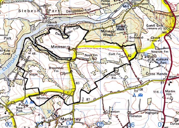
Base map reproduced from the OS map with the permission
of Ordnance Survey on behalf of The Controller of Her Majesty's Stationery
Office, © Crown Copyright 2001.
All rights reserved. Unauthorised reproduction infringes Crown Copyright
and may lead to prosecution or civil proceedings. Licence Number: GD272221
Description and essential historic landscape components
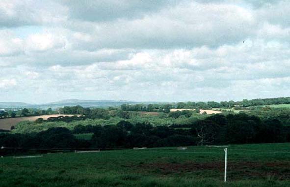
Minwear historic landscape character area lies on the southern side of
the upper Milford Haven waterway (the river here is called the Eastern
Cleddau) and includes part of the mud and marsh of the foreshore and undulating
hills that rise to over 80m above sea level, and continue to rise to the
south of this area. It is an agricultural landscape containing several
dispersed farms. Agricultural land-use is mostly improved pasture with
some arable particularly on higher ground. Deciduous woodland is to be
found in valley bottoms and on some of the steeper valley sides. Some
of the hedgerows contain mature trees, and these with the woodland provide
a wooded aspect to sections of the landscape. The hedgerows are planted
on earth banks and in general are well maintained. The Grade II listed
medieval church of St Womar, Minwear Farm and a 19th century modernised
house is the only cluster of buildings. The farm is typical of the area
– 19th century broadly in the Georgian tradition, two storey, stone
built and rendered with a slate roof, with ranges of 19th century stone
outbuildings arranged around a yard, and several large 20th century steel,
concrete and asbestos agricultural structures. There are few archaeological
sites, and those that are present such as bronze age burnt mounds (possible
prehistoric settlements) do not form a significant component of the landscape.
To the north this area has very good boundary definition against woodland, and likewise to the west where it runs down to the Milford Haven waterway. To the south the landscape is different in character, though still predominantly agricultural. Here there is a zone of change rather than a hard-edged boundary. Only to the east is the boundary difficult to define, but here the landscape has yet to be characterised.
Sources: Charles 1948; Charles 1992; Davies 1946; Martletwy Parish tithe
map 1844; NLW PICTON CASTLE VOL. 1; NLW VOL 88; Owen 1897; Slebech, Minwere
and Newton Parishes tithe map 1847