Home > Historic Landscape Characterisation > Milford Haven Area > |

FREYSTROP 
GRID REFERENCE: SM 954121
AREA IN HECTARES: 357
Historic Background
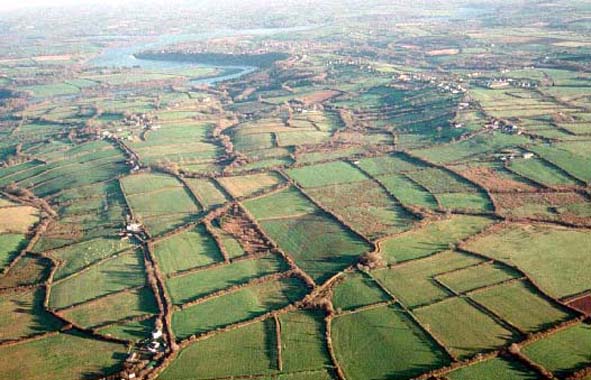
A large character area to the west of the Western Cleddau, comprising
the northern half of Freystrop parish. Freystrop was a member of the Lordship
of Haverford. Its medieval manorial centre probably lay in the vicinity
of the village Lower Freystrop, some distance from the parish church of
St Justinian, suggesting that the church may be a pre-Conquest foundation.
The church was granted to the Tironian priory at Pill before 1400. The
remainder of the settlement pattern in this area is late creation; none
of the farms or hamlets in the area being recorded before the 18th century.
However, it appears that the underlying landscape may be earlier, based
on a medieval open field system and common land– Northmoor Common
– which still lies in the centre of the area. The entire character
area is depicted on a map of 1773. It shows an essentially agricultural
landscape, the main settlement at Lower Freystrop then being a loose nucleation
of about ten houses surrounded by open fields. It would seem that many
of the strips in the open fields were unenclosed – ie. the open
field system was still operating – but some strips had been enclosed
by hedges. By the tithe survey of 1839 the open field system had been
fully enclosed into the distinctive long narrow fields (representing individual
or groups of strips within the former open field) that still survive to
some degree. Only very small pockets of moor, common or other uncultivated
land are shown on the 1773 map. However, an embryonic industrial landscape
is shown interspersed with the agricultural landscape, with numerous isolated
cottages and scattered coal pits lying in the strip fields to the east
of Lower Freystrop and Freystrop village. Small-scale coal mining had
been an element in the economy of the area since the later medieval period,
probably worked seasonally by farmers and farm labourers, but the pits
and houses marked on the 1773 map indicate a more concerted effort at
extracting coal. They include Cardmaker’s Pool Colliery, a fairly
extensive 18th century operation. By the mid 19th century larger pits
were opened close to Freystrop. This brought with it an increase in population
and the development of the modern settlement pattern. Industrialisation
had a detrimental effect on agriculture with former arable fields reverting
to rough grazing. The modern settlement of Freystrop, which has been assigned
to a different historic landscape area, is largely a 20th century nucleation
around a cross-roads, and comprised just a single cottage in 1773.
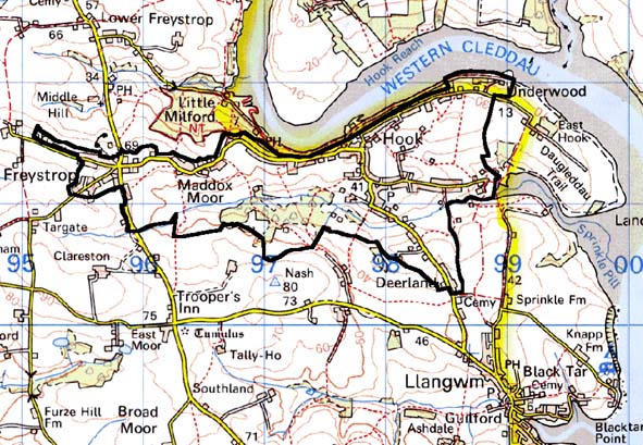
Base map reproduced from the OS map with the permission
of Ordnance Survey on behalf of The Controller of Her Majesty's Stationery
Office, © Crown Copyright 2001.
All rights reserved. Unauthorised reproduction infringes Crown Copyright
and may lead to prosecution or civil proceedings. Licence Number: GD272221
Description and essential historic landscape components
Historically this is a very distinct historic landscape character area.
It consists of the old established village of Lower Freystrop and its
former open fields. It lies across undulating land ranging between 20m
and 80m above sea level. Lower Freystrop consists of a loose cluster of
19th century stone-built and cement rendered, slate roofed, two storey
houses in a style that can be termed Georgian vernacular. Several substantial
ranges of 19th century stone-built farm buildings are located in the village,
most of which are disused and some are dilapidated. Interspersed with
the older dwellings are late 20th century houses in a variety of styles.
There is also a dispersal of 20th century houses across the whole of the
character area. The parish church of St Justinian’s lies some distance
from the village on the side of a narrow valley. Farmhouses of the dispersed
farms are generally 19th century in date, and in the same Georgian tradition
as those of the village. Older outbuildings are 19th century and stone-built,
with most farms having just one or two small ranges. Large assemblages
of modern outbuildings are present on most farms. Many of the fields in
this area still retain their strip-shape from when they were enclosed
from an open field system two centuries ago. Field boundaries consist
of earth banks topped with hedges. Generally most hedges are well maintained,
but there are overgrown examples present as well as some that are becoming
derelict. Woodland where it is present in some valley bottoms and steep
valley sides lends a wooded aspect to parts of the landscape. Land-use
is predominantly improved pasture with some arable and a little rougher
pasture. Industrial features of the old coal industry are not a prominent
component of the landscape. A modern cemetery and a golf-range are evidence
of the influence of the nearby town of Haverfordwest. Archaeological sites
are not common, and do not greatly characterise the area, but include
the possible site of a medieval hospice and the doubtful site of a medieval
church at Middle Hill. There are no listed buildings.
Historically this is a very well defined area, although degradation of certain historic landscape components has led to a blurring between this area and that of some of its neighbours, particularly to the north, west and south. To the east this area forms a hard-edged boundary with woodland alongside the Milford Haven waterway.
Sources: Charles 1992; Edwards 1950; Edwards 1963; Freystrop Parish tithe
map 1839, Ludlow 2002; NLW PICTON CASTLE VOL. 1; NLW VOL. 88; Ordnance
Survey 6” First Ed. 1869