Home > Historic Landscape Characterisation > Milford Haven Area > |

LITTLE MILFORD 
GRID REFERENCE: SM 967122
AREA IN HECTARES: 54
Historic Background
A small character area occupying the upper reaches of the Western Cleddau,
within the parishes of Freystrop and Llangwm. The medieval Manor (and
parish) of Llangwm was a holding of the de Vales until a Roche kinsman,
Gilbert de la Roche, acquired it in the late 13th century. Its relationship
with the Lordship of Haverford, within which it lay, was always a matter
of dispute. Freystrop was also a member of the Lordship of Haverford.
Its manorial centre probably lay in the vicinity of Lower Freystrop. This
character area comprises steep woodland on the west flank of the river,
which is now known as Little Milford Wood. It has been wooded since at
least 1592 when it was recorded as Freystrop Wood, and was part of the
vast Perrot estates. The area also takes in Hook Wood which was included
within George Owen’s list of the greater woods of Pembrokeshire
in c.1601. A small settlement at Little Milford, lying at the head of
a small creek, was recorded since the late 17th century. It developed
as an informal shipping-place, like many other Cleddau settlements, but
unlike the remainder of this area it has experienced change. It was transformed
during the 18th century and 19th century from a local shipping place to
one of the main ports for exporting coal from the Pembrokeshire coalfield.
By 1839 a tramway led down from Freystrop to the quays, and an incline
from Maddox Moor to Little Milford had been established by 1851. However,
the decline in the coal mining industry in the early 20th century followed
by the closure of the Pembrokeshire collieries in 1947, resulted in Little
Milford reverting back to a minor shipping/landing place.
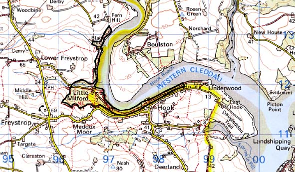
Base map reproduced from the OS map with the permission
of Ordnance Survey on behalf of The Controller of Her Majesty's Stationery
Office, © Crown Copyright 2001.
All rights reserved. Unauthorised reproduction infringes Crown Copyright
and may lead to prosecution or civil proceedings. Licence Number: GD272221
Description and essential historic landscape components
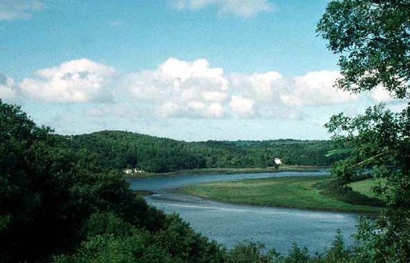
Little Milford historic landscape character area lies on the western bank
of the Western Cleddau and consists almost entirely of woodland. The bank
of the waterway rises steeply, at the base in rocky outcrops, to over
70m. Most of the woodland is old established deciduous, but some consists
of 20th century coniferous plantations. A shipping place lies at Little
Milford where the mouth of a steep-sided tributary valley meets the waterway.
Formerly a busy coal exporting port, Little Milford is now a quite backwater.
A substantial house in the Georgian tradition at Little Milford looks
across the salt marsh and mud of the foreshore. Archaeological sites within
this area are few, and consist of the industrial features mentioned above.
There are no listed buildings.
This is a very well defined area as it is bounded on one side by the Milford Haven waterway and elsewhere by villages and farmland.
Sources: Charles 1992; Edwards 1950; Edwards 1963; Freystrop Parish tithe
map 1839; Llangwm Parish tithe map 1841; NLW PICTON CASTLE VOL. 1; Ordnance
Survey 6” First Ed. 1869; Owen 1897; Rees 1975