Home > Historic Landscape Characterisation > Milford Haven Area > |

ST ISHMAEL’S 
GRID REFERENCE: SM 833071
AREA IN HECTARES: 158
Historic Background
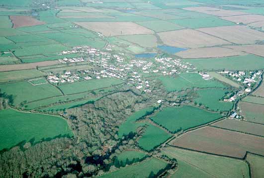
A small historic landscape character area lying on the north shore of
the Milford Haven waterway within St Ishmael’s parish, comprising
the village (and field system) of St Ishmael’s which, with its motte
castle, was the caput of the medieval Sublordship of St Ishmael’s,
a member of the Lordship of Haverford. The parish church with its ‘Celtic’
dedication and three Early Christian Monuments and a possible cist cemetery
lies some distance from the village. The church was mentioned in 1291
when it was a possession of Haverfordwest Priory. A sizeable medieval
settlement is indicated by the remains of an extensive medieval strip-field
system around the village. By the early 19th century estate maps show
that the present morphology of the village and surrounding fields had
been established, although a more extensive strip field system then existed.
Away from the village these strips have been amalgamated into large fields
(these are now considered part of a different landscape character area),
but close to the village the pattern of enclosed strips is still maintained.
These fields were clearly enclosed from an open field farming system.
The date of this enclosure is uncertain, but it is likely to have occurred
in a piecemeal fashion over a number of decades, perhaps in the 17th century
and 18th century. Farms and houses would have been established concomitant
with the enclosure of the open fields. This process was still occurring
in the mid 19th century when Trewarren House was established in 1845.
Considerable mid and late 20th century has maintained the village plan
as shown on early 19th century estate maps.
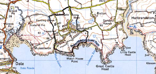
Base map reproduced from the OS map with the permission
of Ordnance Survey on behalf of The Controller of Her Majesty's Stationery
Office, © Crown Copyright 2001.
All rights reserved. Unauthorised reproduction infringes Crown Copyright
and may lead to prosecution or civil proceedings. Licence Number: GD272221
Description and essential historic landscape components
This relatively small historic landscape area includes the village of
St Ishmael’s, surrounding farmland, and a wooded valley within which
the parish church is located. The village, which lies at about 50m above
sea level and is built in and on both sides of a small open valley, consists
of a loose clustering of houses rather than a compact nucleated settlement.
Indeed many of the village lanes have a rural feel and are bordered by
large hedgebanks. The core of the village comprises a mixture of two storey
19th century houses, a pub, a chapel converted to a house and a shop together
with modern houses and bungalows in a variety of styles and materials.
Surrounding the core are several small late 20th century housing estates,
individual houses, a school and sports field. Long narrow fields that
surround the village were once part of the community’s extensive
open field system. Earth banks topped with hedges enclose these fields.
Hedges are generally in good condition and well maintained, and although
some are becoming overgrown there are few hedgerow trees. Land-use is
a mixture of improved pasture and arable. There is a nursery in the area.
The substantial 19th century house of Trewarren lies to the west of the
village, and has walled gardens and landscape features including ponds,
follies located in the valley up from Monk Haven. This valley is heavily
wooded. The medieval church of St Ishmael with early medieval inscribed
stones lies in this valley together with a former vicarage built in 1835
in pattern book Georgian Gothic style. A motte, the site of a medieval
castle lies to the north of the village. Other archaeological sites include
bronze age standing stones, bronze age burnt mounds, find spots of prehistoric
artefacts and a cist cemetery.
Although this is a diverse area - the village, strip fields woodland and the isolated church – it is a coherent historic landscape and includes all the component of a medieval and post-medieval settlement. It is distinct from the large farms with large regular fields that lie to the west, north and east, although there is no hard-edged boundary here. It has a very obvious boundary with the sea cliff historic landscape area to the south.
Sources: Dudley Edwards, J 1972-73; Dudley Edwards, J and Thorne, R G,
1973; NLW MAP 7575; PRO HDX/60/65; PRO D/RKL/1194/3 &14; Owen 1911;
St Ishmael’s Parish tithe map 1839