Home > Historic Landscape Characterisation > Milford Haven Area > |

HOATEN – HASGUARD 
GRID REFERENCE: SM 835092
AREA IN HECTARES: 2557
Historic Background
A large character area lying on the north side of the Milford Haven waterway,
in the parishes of Hasguard, Marloes, St Bride’s, and Walwyn’s
Castle, which lay within the medieval Barony of Walwyn’s Castle.
It also includes most of the parish of St Ishmael’s, roughly coterminous
with the Sublordship of St Ishmael’s which was a member of the Lordship
of Haverford. The majority of the present farms and landholdings can be
identified with medieval manors, which were subject to a complex process
of division and sub-infeudation following the break-up of the Earldom
of Pembroke in 1247. Mullock and Bicton farms are the successors of detached
holdings, lying within the Sublordship of St Ishmael’s, representing
the ½ knight’s fee held of the Lordship of Pembroke by the
Lords of Dale from at least 1247. By the late 13th century, Great Hoaten
and Little Hoaten each amounted to ¼ knight’s fee, held of
St Ishmaels, when rents from the former were assessed at £4 3s 10¼d.
Sandy Haven represented ¼ knight’s fee, also held of St Ishmaels.
Held of the Barony of Walwyn’s Castle were the caput itself at Walwyn’s
Castle village, with its ringwork castle and parish church, 1 knight’s
fee at Hasguard (adjacent to the parish church and glebe), ½ knight’s
fee at St Brides and 9/10ths knight’s fee at Ripperston. Different
individuals held all these manors, while Butterhill was the property of
Haverfordwest Priory. However, the various ownerships did not result in
differing tenurial arrangements, and there was a homogenous pattern of
enclosure. By the 17th century, a number of these holdings had been acquired
by the Allen family who became the major landowners in the area. The earliest
maps of this area, which date to the mid to late 18th century, show a
landscape almost identical to that of today. Virtually every farm had
by then been established and the landscape of large regular fields laid
out. Land holdings were substantial, and the farmers clearly wealthy as
many could afford to commission estate maps that depicted all the details
of their estates, including gardens, orchards and parks. The situation
has changed little over the past two and a half centuries, as is shown
by 19th century estate maps, tithe maps and Ordnance Survey maps. The
origin of the 19th century and modern landscape landscape is not clear.
It is possible that the medieval hamlets employed open field systems that
were engrossed into single holdings and the land enclosed in the late
medieval period or early modern period. A group of small farms to the
west of St Ishmael’s – Whiteholm’s Farm, Slatehill,
The Gann – do not fit this pattern and appear to have been carved
out of common land perhaps in the 18th century, as early 19th century
maps show these as apparently newly created small-holdings. Also, the
farm-names West Lodge and Newfoundland indicate similar late origins,
and neither is mentioned until the 18th century, while Kensington Place
was established by the 19th century owners of St Brides mansion.
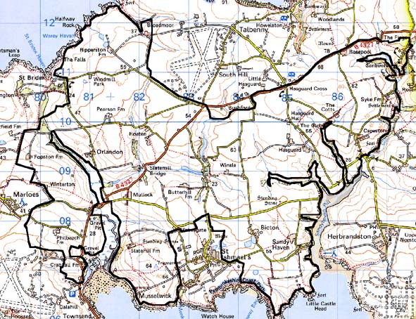
Base map reproduced from the OS map with the permission
of Ordnance Survey on behalf of The Controller of Her Majesty's Stationery
Office, © Crown Copyright 2001.
All rights reserved. Unauthorised reproduction infringes Crown Copyright
and may lead to prosecution or civil proceedings. Licence Number: GD272221
Description and essential historic landscape components
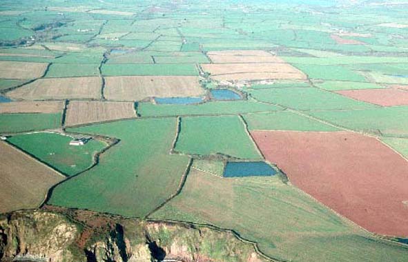
This is a large historic landscape character area lying between the coast
of the Milford Haven waterway and the coast of St Brides Bay. Essentially
it is a plateau between 30m and 60m which is dissected by small, narrow
valleys. It is an agricultural landscape, and apart from small stands
of deciduous woodland on some of the steeper valley sides, occasional
standards in hedges and shelterbelts around settlements, it is virtually
treeless. Farming is highly intensive, of both arable and improved pasture,
with very little rough or under-utilised land. Fields are large and regular,
and bounded by high earth banks topped by hedges. Hedges are generally
well maintained, and because of the windswept nature of the area are rarely
overgrown. In more exposed locations the hedges are very low, but are
more substantial in some of the sheltered valleys. Towards St Brides Bay
there are occasional mortared walls, but these are rare. The settlement
pattern is one of dispersed farms. Farmhouses and outbuildings are generally
large, a reflection of the past and present relative agricultural wealth
of the area. Stone is used almost exclusively in both the older dwelling
and older farm buildings. These buildings have machine cut slate roofs,
although a few examples of stone tile roofs, possibly of local origin,
survive. Many of the houses are cement rendered, but a few examples of
slate-hung walls are present, particularly in the more exposed locations.
Most houses are two-storey and possess features that indicate that they
were remodelled or constructed in the late 18th century or early 19th
century in the Georgian tradition. However, many houses have features
which indicate earlier origins. such as Sandy Haven Farm. Included in
this area are very substantial houses such as the semi-derelict early
18th century and 19th century mansion of Butterhill, the similar house
at Pearson with its walled garden, and the house at Windmill Park which
is grade II listed. Smaller farmhouses and other older dwellings are present
and are generally of late 18th century or 19th century date, with examples
in both the vernacular and the polite Georgian tradition. Included in
this area is the hamlet of Sandy Haven with several 19th century and 20th
century houses. This was originally a small fishing/boat-building hamlet,
although there are no formal quays or jetties. Substantial ranges of stone-built
outbuildings usually accompany the larger farms, often set around a courtyard.
Very large collections of late 20th century farm buildings are a distinctive
feature of the landscape. Some farms have reused World War 2 military
structures as outbuildings such as reconstructed aircraft hangars. In
general the smaller farms have less substantial old and modern outbuildings.
There are no settlement clusters in the area and few modern houses. An
exception are the mid 20th century houses at Walwyn’s Castle. Apart
from the medieval church of St James at Walwyn’s Castle with its
substantial tower, religious buildings are not a major component of the
historic landscape. However, of note is the derelict church of St Peters
at Hasguard which is grade B listed, and a small 19th century chapel on
an arm of the Sandy Haven inlet. Individual archaeological sites provide
only a minor component of the historic landscape, but they include iron
age forts, bronze age standing stones, round barrows and burnt mounds,
several prehistoric flint working floors, and traces of a windmill at
Windmill Park from the post-medieval period.
To the west, south and east this area is generally well defined as it borders character areas that contain distinctively different components, except to the south against St Ishmael’s area where there is no clear boundary. Similarly to the north this area merges with areas yet to be defined.
Sources: Charles 1992; Jones 1996; Marloes Parish tithe map 1843; NLW MAP 7575; Nash 1986; Owen 1911; Owen 1918; PRO D/ER/3/6; PRO/D/RKL/1194/14 &17; PRO HDX/80/66; St Ishmael’s Parish tithe map 1839; Walker 1950; Walwyn’s Castle Parish tithe map 1842