Home > Historic Landscape Characterisation > Milford Haven Area > |

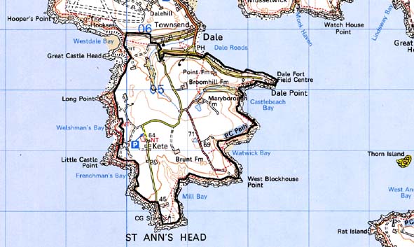
ST ANN’S HEAD 
GRID REFERENCE: SM 810044
AREA IN HECTARES: 438
Historic Background
This area lies entirely within the parish of Dale, which is more-or-less
coterminous with the medieval Manor of Dale. This formed a subordinate,
mesne lordship of the barony of Walwyn’s Castle, assessed at one
knight’s fee, with a caput probably in the vicinity of the present
village. The manor had, by the 13th century at least, been acquired by
the de Vale dynasty and in 1307 ‘The heirs of Robert de Vale hold
one knight’s fee at Dale containing 10 carucates’. It appears
to be Robert de Vale who relocated Dale Castle, the caput of the manor,
from Great Castle Head, a re-used promontory fort in the neighbouring
character area to the west, to the village of Dale. Robert de Vale died
c. 1300 and the manor of Dale was divided between his daughters as co-heiresses.
It found its way into the hands of the Walter family of Rosemarket who
continued to hold Dale until the late 17th century when it passed to the
Paynters of Broomhill, then the Allens of Gelliswick, and then to the
Lloyd-Philipps family who still own Dale Castle. By the time of the tithe
survey in the mid 19th century the agricultural landscape that we see
today had been firmly established. It is likely that originally this area
was once part of Dale’s open field system (traces of enclosed strip
fields can still be traced to the north of the village), that was enclosed
and engrossed into compact land holdings and farms established in the
16th century and 17th century. Although some farms may have been established
much earlier, as a record of Snailston in 1376 suggests a settlement had
been established at this site by this date. Some farms became substantial
holdings, such as Broomhill, which had been the home of the Paynter family
since 1599. Two successive windmills were erected in the centre of this
area during the 18th century, but were superseded by the present structure
north of Dale village in the early 19th century. Henry Tudor (Henry VII)
landed in the Milford Haven waterway in 1485, on his way to Bosworth Field,
and tradition has it that he had a chapel constructed on St Ann’s
Head to commemorate the event. George Owen in the late 16th century describes
a decayed chapel here and it is possible that the chapel also served as
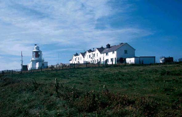
a lighthouse. Certainly, St Ann’s Head is the site of the oldest
lighthouse in Wales, with a light recorded here in 1662. Over the past
three centuries several lighthouses and associated structures have been
constructed here. There is still a working light here. However, apart
from quarrying, and possibly some excavation for copper ore, the economy
remained overwhelmingly agricultural until the 19th century. Following
the tithe survey, two substantial forts were constructed in this area,
Dale Fort in 1853-57 and West Blockhouse Fort in 1854-57, as part of a
massive defensive system for Milford Haven. West Blockhouse was constructed
over the remains of a 16th century gun tower, one of a pair built to protect
the mouth of the Haven. East Blockhouse survives at Angle on the opposite
shore. The construction of the 19th century forts signalled the start
of a century of military construction in this area, including coastal
gun batteries at West Blockhouse built in 1901-04, World War 2 anti-aircraft
batteries and searchlight batteries, and Kete naval training camp. All
these are now disused.
Base map reproduced from the OS map with the permission
of Ordnance Survey on behalf of The Controller of Her Majesty's Stationery
Office, © Crown Copyright 2001.
All rights reserved. Unauthorised reproduction infringes Crown Copyright
and may lead to prosecution or civil proceedings. Licence Number: GD272221
Description and essential historic landscape components
St Ann’s Head historic landscape character area comprises a windswept
peninsula projecting south into the mouth of the Milford Haven waterway.
The peninsula is edged by high sea cliffs where it meets the sea, and
inland to the north borders Dale village. It is a plateau lying between
60m and 70m almost entirely given over to agriculture, with both pasture
and arable present. There is very little rough or unused land. Apart from
small stands of deciduous woodland on the sides of small sheltered valleys
it is an almost treeless landscape. The field pattern is one of regularly
shaped, medium-sized fields bounded by earth banks. On occasions these
banks are massive. They are topped with hedges which, given their exposed
location, are generally low and windswept. Farms in the area vary in size.
Some contain very large collections of modern steel and asbestos outbuildings
that are prominent features of the landscape. Older farm buildings are
generally stone-built, 19th century and of just one or two ranges. Farmhouses
are mostly of late 18th century or 19th century date, two-storey, stone-built
with cement rendering, slate roofs, and in either the vernacular style
or polite tradition. A massive chimney at grade II listed Broomhill, however,
is probably from the 17th century. Some dwellings date to the mid 19th
century. Two other important landscape components are included in this
area. The first consists of 19th century and 20th century military sites.
The grade II listed Dale Fort and grade II* listed West Blockhouse Fort
both date to the mid 19th century, and are massive stone built fortifications.
Both are well maintained, with Dale Fort a field studies centre and West
Blockhouse converted to holiday accommodation. A massive gun battery dating
to the early 20th century and not abandoned until the 1950s lies close
to West Blockhouse. World War 2 gun batteries and searchlight batteries
also lie in the area. During World War 2 a naval training school was established
at Kete. Apart from a few buildings now in agricultural use this has been
demolished and the land returned to agriculture, although wire fences
rather than earth banks divide the area. The second historic landscape
component consists of lighthouses, a coastguard station and associated
houses all located on St Ann’s Head itself, within an enclosure
of mortared stone. These date to the 19th century and 20th century. At
West Blockhouse 20th century navigation markers are prominent elements
of the landscape. Apart from structures associated with 19th century and
20th century military installations, archaeological remains are slight,
and generally consist of prehistoric flint scatters, but there are three
grade II listed limekilns. The earthworks of a prehistoric fort at Dale
Point, now partially overlain by Dale Fort, are major exception.
St Ann’s Head historic landscape character area is distinctive and well defined. It stands in sharp contrast to the sea cliffs that almost surround it, and the distinction between it and Dale village with its fields to the north can be well observed.
Sources: Calendar of Charter Rolls 2; Charles 1992; Dale Parish tithe map 1847; Dresser, 1959; Hague 1994; Charles 1992; Jones 199; Ludlow, in Crane forthcoming; Nash 1986; Owen 1911; Owen 1918; Ramsey and Williams 1992