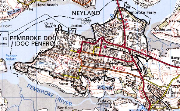
Home > Historic Landscape Characterisation > Milford Haven Area > |

PEMBROKE DOCK 
GRID REFERENCE: SM 963034
AREA IN HECTARES: 455
Historic Background
During the medieval period this area, a small peninsula situated in St.
Mary’s Parish, Pembroke, lay within the Manor of Kingswood with
Golden, which was a demesne manor of the lordship of Pembroke. Arable
land-use is recorded in detailed accounts from the 14th century and 15th
century, with issues from wheat, beans, peas, barley and oats. However,
meadowland, sheep and wool are also recorded, along with profits from
cloth-processing – two fulling-mills were established during the
15th century. Income was also derived from the ferry that crossed the
waterway to Burton. This was not replaced by a bridge until the later
20th century. During the post-medieval period the area became part of
the Bush estate. The partial construction of a fort at Paterchurch in
1758 did not alter this area’s agricultural aspect, as shown on
estate maps of 1772 and 1813, although it would seem that as with most
inlets on the Haven small-scale ship building was being carried out at
Bentlass on the Pembroke River and at Pembroke Ferry. The Admiralty’s
decision to relocate their dockyards from Milford Haven to a new site
at Paterchurch in 1812 marked the beginning of the new town of Pembroke
Dock. Growth was rapid. An estate map of 1848 titled ‘Town of Pater’
shows the grid pattern of the embryonic town. Many of the plots are shown
occupied, but many others are awaiting development. Indeed, a later hand
has annotated the map with the names and types of buildings that were
subsequently built. The naval dockyards were opened in 1814, extended
in 1830-32 and again in 1844. In 1832 a stone pier at Hobbs Point was
opened and later an Hotel and stables for Irish steam packet passengers;
this service having been transferred from Milford Haven. As part of the
overall defence for Milford Haven several large installations were constructed
within this area in the mid 19th century, including a large ‘star’
fort and two gun towers on the foreshore by the dockyards. In 1864, the
first train ran from Pembroke Dock to Tenby. The line was later extended
into the dockyards. Civilian shipbuilding yards on Water Street, Front
Street and Lower Meyrick Street all operated in the 19th century, as well
as a substantial yard at Jacob’s Pill on the Pembroke River. This
last installation was opened in 1874 and closed in 1884, when it was converted
to an isolation hospital. Late in the 19th century a torpedo stores was
established at Pennar Point and submarine mining experiments were carried
out on the river here. The dockyards were one of the world’s most
important naval shipbuilding centres, with over 260 ships launched in
its 112 year life. The development of larger ships, culminating in the
dreadnought class, signalled the end of the dockyards. The Admiralty was
unwilling to invest in new facilities, and in 1907 men were laid off.
The dockyard was abruptly closed in 1926. In 1930, the establishment of
a RAF flying-boat base in the eastern part of the former dockyard provided
some employment until its closure in 1959. During the early and mid 20th
century other military installations were located in this area including
barracks, oil and ammunition stores. More recently, a ferry service to
Ireland has been operating at a new base in the former dockyard. The town
of Pembroke Dock expanded in conjunction with the military and industrial
development, at first close to the dockyards and at Pennar, and then,
in the 20th century, outside this historic town core.
Base map reproduced from the OS map with the permission
of Ordnance Survey on behalf of The Controller of Her Majesty's Stationery
Office, © Crown Copyright 2001.
All rights reserved. Unauthorised reproduction infringes Crown Copyright
and may lead to prosecution or civil proceedings. Licence Number: GD272221
Description and essential historic landscape components
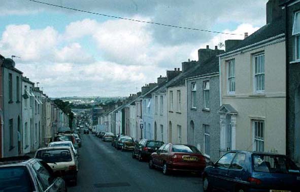
Pembroke Dock is an urban historic landscape character area. It is centred
on the 19th century and early 20th century naval dockyards, and smaller
private shipbuilding yards. The naval dockyards are surrounded by a high
defensive wall and flanked by two 19th century gun towers. Large parts
of the yard are now given over to modern industry, including the Irish
ferry port, but several large stone buildings in the Georgian tradition
close to the dock’s entrance provide a strong architectural signature.
Several of the original docks also survive as do a collection of 20th
century military structures, including two large hangars built for flying
boats. Pembroke fort, originally constructed on an open hillside overlooking
the dockyards is now surrounded by development. The 19th century town
is built in a grid pattern, and this, together with the survival of many
wide streets of contemporaneous houses and other buildings, provides a
strong architectural signature. The combination of a planned street pattern
and high survival rate of contemporaneous houses and other buildings provides
Pembroke Dock with a coherent historic character that is rarely matched
in other Welsh town. These 19th century dockyard worker houses are generally
of two storey terraces, cement rendered, and broadly in the Georgian tradition.
The social and economic landscape of the town is manifest in details such
as the larger ‘foreman’ houses that stand at the ends of terraces.
Three storey houses on some street corners in the commercial centre emphasise
the importance of certain road intersections. At Pennar over looking the
dockyards to the south the grid pattern of wide streets is maintained,
but here terraces of single-storey cottages provide a very distinctive,
if not unique, aspect to the town. In all there are 125 listed buildings
within the town. There is not a great deal of later 19th century and early
to mid 20th century housing, but later 20th century housing and other
buildings testify to intensifying growth in this period. Several of the
20th century military installations have been redeveloped into offices
and light industrial estates; many have been demolished and the land restored.
The Cleddau Bridge, which replaced a ferry, has rejuvenated the northern
side of the town. It is here that much of the light industry is located.
A golf course lies within this area.
This historic landscape character area is defined to the west, north
and east by the sea. On the other side it neighbours farmland. However,
it is likely that Pembroke Dock will soon merge with Pembroke as only
a few fields separate them.
Sources: Carradice 1991; Findley 1875; Jack 1981; Owen 1918; Peters 1905;
Price 1986; St Mary’s Pembroke Tithe Map 1841; PRO D/BUSH/6/26;
PRO D/BUSH/6/27; PRO D/BUSH/6/40;