|

 LYDSTEP HAVEN
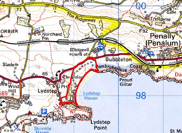
GRID REFERENCE: SS 091983
AREA IN HECTARES: 28
Historic Background
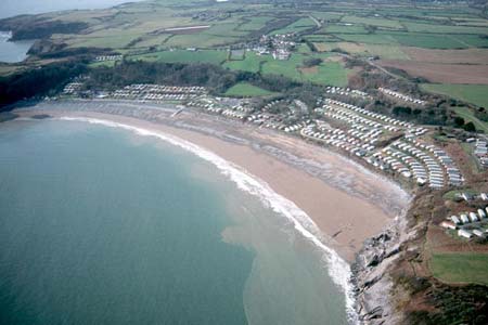
A small area of modern Pembrokeshire, comprising the east-facing slope down to the foreshore of Lydstep Haven. During the medieval period, it lay within the Anglo-Norman manor of Manorbier (and Penally) which was a mesne lordship or honorial barony held, by the service of 5 knights, of the Lordship and Earldom of Pembroke, a heavily Anglicised region that was brought under Anglo-Norman control before 1100, re-organised along English manorial lines and never retaken by the Welsh. The barony had been held, since the very early 12th century, by the de Barris and, on their extinction in 1392, was sold to the Dukes of Exeter before reverting to the crown in 1461. From that point onwards it was leased to a succession of individuals before being settled on the Philippses of Picton Castle, with whom it remained until the 20th century. However, John Adams acquired this character area by the late 18th century and later established a gentry-house, Lydstep House, on east-facing slopes. It was a virgin site. There appears to have been no association between this house and Lydstep Palace, the late medieval building in Lydstep village (see Lydstep character area). The tithe map of 1842 shows a small dwelling situated in a patchwork of smallish, regular enclosures. Lydstep House was retained by the Adams family through most of the 19th century. It was rebuilt and enlarged in the late 19th century, when the surrounding landscape was remodelled as a small park and gardens. Three lodges were added in c.1900-1910. West Lodge, and the home farm which was erected on the east side of Lydstep village in the 1840s-50s, are in Lydstep character area. The park and house were acquired for use as a caravan park and holiday centre in the 1960s, and they remain so today.
Description and essential historic landscape components
Lydstep Haven historic landscape character area includes the foreshore above the high water mark and its immediate hinterland up to the A4139 road at approximately 50m above sea level. Formerly this landscape was characterised by the farmland gardens of Lydstep House, but is now dominated by a large caravan park. Lydstep House, a late 19th century pebble-dashed Jacobethan-style house with a slate roof is used as part of the tourist facilities, but retains much of the original interior. The early 20th century North and South Lodges, built of roughly coursed limestone under red tile roofs to a pattern book design are also included in this area, but not West Lodge, which has been assigned to Lydstep village. Apart from deciduous woodland on the steep slope above the house, the whole of the remainder of this area is given over to static caravans, roads and tracks and related infrastructure. Recorded archaeology is limited to prehistoric finds on the foreshore that are associated with peat deposits.
Lydstep Haven is a distinct and well-defined historic landscape character area. It is bordered to the east by the coast and elsewhere by Lydstep village or fields and farms.
Sources: Howells 1987; Lewis 1833; Manorbier Parish tithe map 1842; Pembrokeshire Record Office D/MW/2/165; Penally Parish tithe map 1842
Base map reproduced from the OS map with the permission
of Ordnance Survey on behalf of The Controller of Her Majesty's Stationery
Office, © Crown Copyright 2001.
All rights reserved. Unauthorised reproduction infringes Crown Copyright
and may lead to prosecution or civil proceedings. Licence Number: GD272221