|

 LYDSTEP
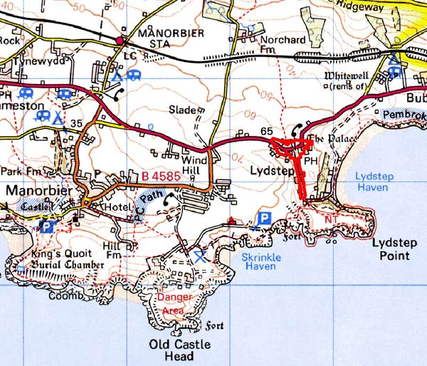
GRID REFERENCE: SS 085983
AREA IN HECTARES: 6
Historic Background
A small area of modern Pembrokeshire, comprising the built-up village of Lydstep. Lydstep’s name derives from Lydstep Haven, rather than the other way around. The name is Scandinavian in origin indicating that the area was known and perhaps even settled by Norse seafarers during the early medieval period. It is first recorded, as ‘Loudeshope’ in 1362. During the later medieval period it lay within the Anglo-Norman manor of Manorbier (and Penally) which was a mesne lordship or honorial barony held, by the service of five knights, of the Lordship and Earldom of Pembroke, a heavily Anglicised region that was brought under Anglo-Norman control before 1100, re-organised along English manorial lines and never retaken by the Welsh. The barony had been held, since the very early 12th century, by the de Barris and, on their extinction in 1392, was sold to the Dukes of Exeter before reverting to the crown in 1461. From that point onwards it was leased to a succession of individuals before being settled on the Philippses of Picton Castle, with whom it remained until the 20th century. Lydstep’s environs appear to have occupied a position of some importance during the pre Anglo-Norman Conquest period, at least in the cultural consciousness of Dyfed. An 11th century document, said to be a copy of a 6th century original, lists several locations in the district one of which, ‘Pwll Arda’, has been tentatively identified as Lydstep. However, the traditional identification of Lydstep as the seat of the 6th century ‘King of Dyfed’ Aircol Lawhir has, at present, no support. Nevertheless, that it was regarded as a place of continuing importance is demonstrated by its post-Conquest function as a meeting place. It is recorded in the 16th century that the freeholders of the manor of Manorbier and Penally all owed suit fortnightly to the court of ‘Langstone’. It has been argued that this was an open air moot-place, situated in a subcircular field around a ?bronze age standing stone on the boundary between Manorbier and Penally parishes, just north of the late medieval building called Lydstep ‘Palace’. It has been further argued that the Palace took over from the field as the court-house. There was, apparently, another late medieval masonry building in the village, called the ‘Palace of Arms’. In 1362, one ‘John of Lydstep’ held a knight’s fee of John Carew at Jeffreyston. However, Lydstep may not have been formally constituted as a manorial settlement or vill. Nevertheless, according to detailed surveys of 1601, 1609 and 1618 there were 3 freeholders at Lydstep, who paid cash rents, and one who rendered a customary rose. No other tenants are listed, and there is no indication of what other properties occupied the village. The present settlement of Lydstep may then largely be a creation of the 17th century and later. Its form suggests little nucleation and certainly no planned elements. By the late 18th century the northern side of what is now Lydstep village had been acquired by the Norchard estate. Maps of the ‘Demesne and Lordship of Norchard’, from 1772 and 1774-5, show a loose cluster of five or six buildings in the village, including Lydstep Palace. The picture is similar to the tithe survey of 1841. Any importance that Lydstep Palace possessed had, by the early 19th century, entirely diminished, but its use as a dwelling continued; the tithe map depicts the building and the field within which it lay as a ‘cottage and garden’ occupied by one Thomas Lewis, a tenant. There appears never to have been any connection between the Lydstep Palace and Lydstep House, the mansion that still stands on the foreshore of Lydstep Haven, occupied by the Adams family in the 19th century (see Lydstep Haven character area). Its home farm was erected on the east side of Lydstep village in the 1840s-50s. Subsequent maps show very little change has occurred in village size and morphology. Lydstep House West Lodge and 20th century houses have been built in a piecemeal fashion.
Description and essential historic landscape components
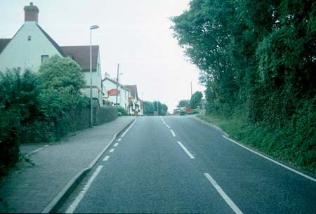
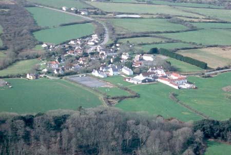
This very small historic landscape character area comprises just Lydstep village. It lies at about 50m above sea level, approximately 1km from the coast, and essentially consists of an unplanned cluster of buildings along the A4139. Local limestone is the universal building material. Lydstep Palace, a ruined but recently conserved late medieval stone-vaulted building lies at the village core. Nineteenth century buildings are of stone with slate roofs and comprise a few two storey houses and old agricultural buildings. Although the houses are in the vernacular tradition, their large window openings and symmetry of design acknowledge the polite ‘Georgian’ style. However, the red tile roofs and the use of rough-dressed limestone in early 20th century buildings characterise the village. The Lydstep estate was probably responsible for introducing this style into the village, perhaps with the construction of the Arts and Crafts style West Lodge in 1912. Red tile is now used on the public house, a large range of old farm buildings converted to holiday accommodation, and recently constructed houses. In the latter example white painted cement render and redbrick detailing emphasises the red tile roofs. Estate influence is also evident in the use of rough-dressed limestone in gateposts and some boundary walls. Other buildings include mid 20th century bungalows. Modern detached housing is spreading down the track towards Lydstep House.
This is a distinct and well-defined area, and contrasts with the neighbouring landscape of farms and fields and holiday development.
Sources: Charles 1992; King and Perks 1970; Kissock 1993;
Lewis 1833; Ludlow 1996; Manorbier Parish tithe map 1842; Milne 2001;
National Library of Wales NLW 88; Owen 1892; Pembrokeshire Record Office
D/MW/2/165, D/Bush/26/6; Ordnance Survey 1:10560, Pembs. Sheet 44NW, 1888;
Penally Parish tithe map 1842; Walker 1992
Base map reproduced from the OS map with the permission
of Ordnance Survey on behalf of The Controller of Her Majesty's Stationery
Office, © Crown Copyright 2001.
All rights reserved. Unauthorised reproduction infringes Crown Copyright
and may lead to prosecution or civil proceedings. Licence Number: GD272221