|

 HILL FARM -BALDWIN'S MOOR
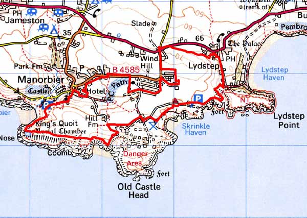
GRID REFERENCE: SS 073976
AREA IN HECTARES: 152
Historic Background
An area of modern Pembrokeshire situated between Manorbier and Lydstep, within in the parish of Manorbier. During the medieval period, this lay within the Anglo-Norman manor of Manorbier (and Penally) which was a mesne lordship or honorial barony held, by the service of 5 knights, of the Lordship and Earldom of Pembroke, a heavily Anglicised region that was brought under Anglo-Norman control before 1100, re-organised along English manorial lines and never retaken by the Welsh. The barony had been held, since the very early 12th century, by the de Barris and, on their extinction in 1392, was sold to the Dukes of Exeter before reverting to the crown in 1461. From that point onwards it was leased to a succession of individuals before being settled on the Philippses of Picton Castle, with whom it remained until the 20th century. It comprises a landscape of regular, medium-sized enclosures, quite distinct from the strip fields of Manorbier Newton character area to the north. It may be that the strip fields – which appear to have bronze age origins – formerly extended into this area but were lost. Tenants within the lordship held land by freehold, and by two forms of copyhold called ‘husbandry hold’ and ‘censory hold’, which appear to be relics of an earlier, feudal tenure. It appears from the evidence of three surveys, in 1601, 1609 and 1618, that the area comprised two holdings, Hill and Skrinkle. Hill was occupied by one husbandry tenant and one censory tenant, while Skrinkle was occupied by a censory tenant. Censory lands appear in the main to have formerly been baronial demesne land which, through absentee landlords in the late 14th centuryand 15th centuries, were allowed to become ‘decayed lands’. Their history is thus quite distinct from the husbandry holdings which appear to have been established within the communal strip fields. The surveys suggest that the land was still largely unenclosed, although the process may have begun. The present system of medium-sized fields appears to predate late 18th century or 19th century enclosure, with an area of later enclosure at the eastern end. of the area. Hill included a substantial farm, with three barns, three haggards (corn hay barns) and a cowhouse, while Skrinkle comprised two substantial farms with 2 barns, 2 haggards and 2 cowhouses. An increase in arable was recorded. One of the Skrinkle farms may be represented by the present Baldwin’s Moor, which was rendered as ‘Baldwin’s Moor alias Skrinkle Lays’ in 1766. Late 18th century estate maps, and the tithe map of 1842, show this area much as today, although Skrinkle farmstead has moved from an original site further to the west. Lime-burning was undertaken near Hill, and during World War 2 a military airfield, attached to Manorbier Camp, was established over part of this area. Virtually all traces of this have now gone. A sports ground now occupies part of the area.
Description and essential historic landscape components
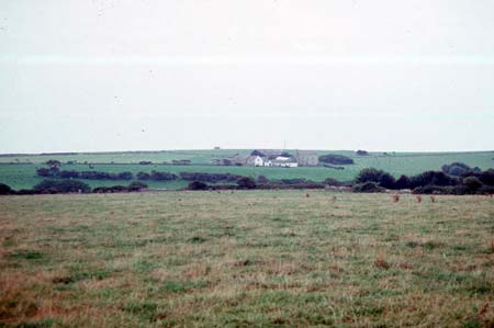
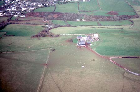
This is an agricultural historic landscape character area sandwiched between the high sea cliffs of the coast and a military camp to the south, and Manorbier village, farms and fields to the north. It lies on the coastal plain at approximately 50m to 70m above sea level. It is exposed to the prevailing south-westerly Atlantic winds and is therefore virtually treeless with hedges reduced to low lines of straggling bushes. This gives a very open aspect to the landscape. It is nevertheless divided into medium-sized, fairly regular fields, the boundaries of which are composed of low stone-faced banks and mortared walls. The latter are generally in a poor state of repair. Agricultural land-use is improved pasture. Older buildings are of local limestone under slate roofs. Elevations are either cement rendered or bare stone, with a few examples slate hung. Houses are mainly late 18th century or earlier 19th century, though some have details suggesting that earlier periods of building are incorporated within them. These houses are two-storey and in the Georgian tradition, although some have strong vernacular traits, such as small windows, asymmetrical design and large chimneys. A single-storey house attached to one of these later houses provides direct evidence of an earlier building tradition. Older farm buildings are relatively large and complex, and are arranged semi-formally around courtyards close to the dwellings. Two- and single-storey examples are present. Most farms have a barn, cowshed, cart house and other buildings indicating a mixed farm economy at the time of their construction in the early-to-mid 19th century. One set of farm buildings has been converted to non-agricultural use and another lies derelict. One farm has an extensive range of modern steel, concrete and asbestos agricultural buildings. Former mid 20th century military roads, remains of related installations, and a modern steel and concrete Youth Hostel are situated close to the coast. Recorded archaeology is limited to find spots of prehistoric date; these do not characterise the area.
The treeless and mainly hedge-less character of this area distinguishes it from a neighbouring agricultural area to the north. On other sides historic landscape character areas including the coastal zone, a military camp and villages define the boundaries of this landscape with some precision.
Sources: Charles 1992; Manorbier Parish tithe map 1842; National Library of Wales NLW Vol 88, Picton Map 11, Picton Castle Vol 4; Pembrokeshire Record Office HDX/945/2; Walker 1992
Base map reproduced from the OS map with the permission
of Ordnance Survey on behalf of The Controller of Her Majesty's Stationery
Office, © Crown Copyright 2001.
All rights reserved. Unauthorised reproduction infringes Crown Copyright
and may lead to prosecution or civil proceedings. Licence Number: GD272221