|

 EAST MOOR AND WEST MOOR
GRID REFERENCE: SS 046989
AREA IN HECTARES: 453
Historic Background
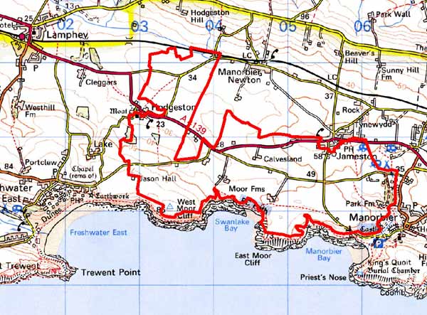
An area of modern Pembrokeshire, between Manorbier and Hodgeston. The majority of the area lies within the parish of Manorbier. During the medieval period, this lay within the Anglo-Norman manor of Manorbier (and Penally) which was a mesne lordship or honorial barony held, by the service of 5 knights, of the Lordship and Earldom of Pembroke, a heavily Anglicised region that was brought under Anglo-Norman control before 1100, re-organised along English manorial lines and never retaken by the Welsh. The barony had been held, since the very early 12th century, by the de Barris and, on their extinction in 1392, was sold to the Dukes of Exeter before reverting to the crown in 1461. From that point onwards it was leased to a succession of individuals before being settled on the Philippses of Picton Castle, with whom it remained until the 20th century. It comprises a landscape of regular, medium-sized enclosures, quite distinct from the strip fields of the Manorbier Newton character area to the north. It may be that the strips – which appear to have bronze age origins – formerly extended into this area, but have been lost owing to different farming practices. According to an account of 1582, much of this area represented what had formerly been baronial demesne land which, through absentee landlords in the late 14th and 15th centuries, had been allowed to become ‘decayed lands’. The far east end of the area in fact included Manorbier Castle Park. By the early 17th century the demesne was largely being rented out. Tenants within the lordship held land by freehold, and by two forms of copyhold called ‘husbandry hold’ and ‘censory hold’. Most of this character area, like other former demesne lands, represented censory holding(s) which were included, for assessment purposes, within Manorbier Newton. Their history is thus quite distinct from the husbandry holdings which appear to have been established within the communal strip fields. It appears from the evidence of three surveys, of 1601, 1609 and 1618, that the land was still largely unenclosed, although the process of enclosure may have begun. By the time of the surveys there was no game or deer in the park, which had been divided into three enclosures. Over the three surveys, the censory holding(s) – called ‘Calvesland’ by 1618 - appear to have represented poor land and only 16 acres of arable, 4 barns, and 3 cowhouses, are recorded. However, West Moor was recorded – as ‘Moor’ – as a husbandry holding. East Moor appears not to have been recorded which may be further evidence of demesne origins. It had become a minor gentry house by the 17th century, when it was a possession of the Lort family of Stackpole, assessed for 7 hearths in 1670 and described by Fenton, in 1811, as ‘one of the chief mansions of this district about 200 years ago’. It had passed to the Owens of Orielton by the 18th century. The character area also includes similar field systems in the neighbouring parish of Hodgeston. This was another mesne lordship held of the Earldom of Pembroke. It was divided between a number of co-heirs on the death of the Marshal Earls in 1245, and continued to be held by co-owners until it too became part of the Owen holdings in the late 17th century - early 18th century. It may then be that the pattern of enclosure was undertaken under Owen tenure, during the late 17th century - early 18th century. There are few historic maps of this area, and those that are available such as a late 18th century estate map and the tithe maps of the c. 1840 show a landscape similar to that of today. In addition the tithe maps show small-scale limestone quarrying and limekilns to the east of Hodgeston village.
Description and essential historic landscape components
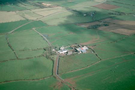
A historic landscape character area generally between 30m and 50m lying on the south Pembrokeshire coastal plain immediately inland of high sea cliffs. Land-use is mostly improved pasture, with some arable and virtually no rough ground. It is open to southwesterly Atlantic winds, and therefore apart from trees planted for shelter close to houses woodland is not a characteristic of the landscape. Indeed, hedges which are dense and well maintained in the northern part of this area fade first to straggling lines of bushes then to nothing close to the exposed coast. Boundaries are a mixture of stone-faced banks and mortared walls. Banks with hedges predominate in the northern section of this area while to the south walls are more common, now broken down and supplemented with wire fences. Fields are relatively large and square or rectangular in shape. The settlement pattern is one of dispersed farms. Older buildings are almost entirely 19th century in date, built of local limestone (cement rendered or bare, although with farm buildings are invariably bare stone), with slate roofs. Farmhouses vary in size and style, ranging from two-storey early 19th century Georgian houses, through to later 19th century two storey double-fronted vernacular houses. However, the large window openings and symmetry of the vernacular houses indicate a degree of polite Georgian style influence. Similarly farm buildings vary, with extensive ranges, sometimes arranged informally around a yard associated with the larger buildings, down to a single range attached to the end of a small house at the lower end of the scale. Farm buildings on some of the smaller farms have been converted to non-agricultural use, while larger farms often have modern steel, concrete and asbestos agricultural buildings. There are few modern dwellings in this area. There is a large caravan park and campsite. The A4139 road crosses from east to west and numerous lanes bisect the landscape. Historic boundaries have been removed along sections of the A4139 and replaced by fences. Recorded archaeological sites do not strongly characterise this area. They fall into two main categories, prehistoric flint working floors and post-medieval limekilns.
East Moor and West Moor historic landscape character area shares many of the landscape components of the area (yet to be defined) to the west. Consequently it is not possible to define a hard-edged boundary here. Elsewhere there is clear definition between this area and strip fields and Jameston village to the north, the coastal strip to the south and Manorbier village to the east.
Sources: Hodgeston Parish tithe map 1840; Jones 1996;
King and Perks 1970; Manorbier Parish tithe map 1842; National Library
of Wales Picton Map 5; Walker 1992
Base map reproduced from the OS map with the permission
of Ordnance Survey on behalf of The Controller of Her Majesty's Stationery
Office, © Crown Copyright 2001.
All rights reserved. Unauthorised reproduction infringes Crown Copyright
and may lead to prosecution or civil proceedings. Licence Number: GD272221