Home > Historic Landscape Characterisation > Lower Teifi Valley > |

 PENTOOD MARSH
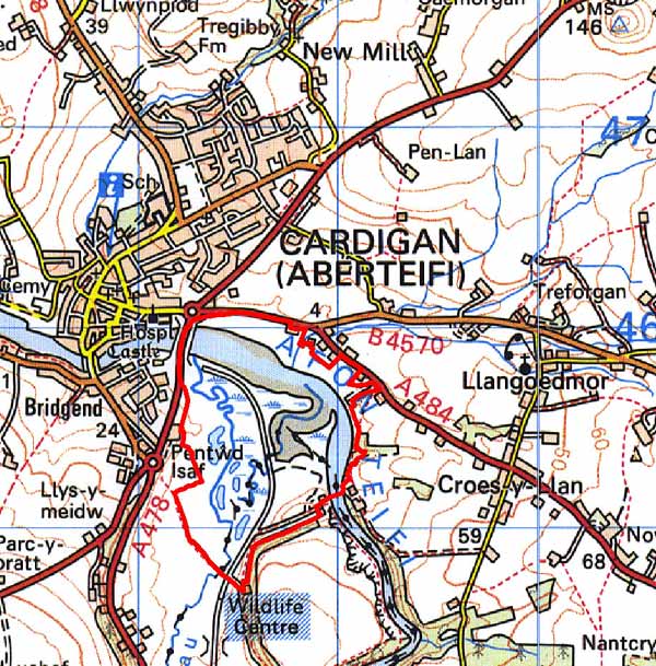
GRID REFERENCE: SN186453
AREA IN HECTARES: 88
Historic Background
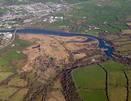
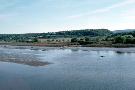
This is a small area within modern Ceredigion and Pembrokeshire comprising marsh, on the southern bank of the Afon Teifi. It is a nature reserve. Until recently, the area lay entirely within Pembrokeshire. It is divided in two by the Afon Piliau, a tributary of the Teifi, which during the medieval period was the boundary between Cantrefs Cemais and Emlyn, and their successor Anglo-Norman lordships, Cemais and Cilgerran, which were established in c.1100 and absorbed into Pembrokeshire when it was established in 1536. However, the area occupied the ‘Welshries’ of both lordships, within which Welsh law, customs and tenurial patterns were maintained throughout the medieval period and into modern times. This area has always comprised marginal land and was once probably less extensive than today, the salt-marsh accruing at the confluence of the Piliau with the Teifi. The marsh had, however, reached its present extent by the 1840s, when it was recorded as marginal land on the tithe maps. The old Whitland - Cardigan railway line (constructed in 1869) crosses the marsh and is now a footpath/cyclepath. The line - which gained a place in local affections and was nicknamed the ‘Cardi Bach’ - was operational until the 1960s, mainly conveying milk and holiday traffic to Cardigan and St Dogmaels.
Description and essential historic landscape components
Pentood and Rosehill are tidal marshes dominated by reed beds, immediately upstream of the Cardigan bypass Bridge at the confluence of the Afon Teifi and the Afon Piliau. It is not a large area, measuring just 1.3km by 0.8km, but distinct, and contrasts with the neighbouring landscapes of fields and farms. It is a nature reserve. A visitor centre is located here and the old railway line has been converted to a footpath. There are no recorded archaeological sites.
Sources: Cilgerran parish tithe map 1844; Fenton,
R., 1811 A Historical Tour through Pembrokeshire, London; Howells, B E
and K A (eds.), 1977, The Extent of Cemaes, 1594, Haverfordwest; Lewis,
S, 1833, A Topographical Dictionary of Wales 1 & 2, London; Llangoedmor
parish tithe map 1839; Owen, H (ed.), 1914, Calendar of Pembrokeshire
Records, 2, Price, M R C, 1984, The Whitland and Cardigan Railway, Oxford;
London; Rees, W, 1932, ‘Map of South Wales and the Border in the
XIVth century’; Rees, W, 1951, An Historical Atlas of Wales, London;
Regional Historic Environment Record housed with Dyfed Archaeological Trust; Sambrook,
P, 2000, ‘St Dogmaels Historic Audit’, unpublished report
by Dyfed Archaeological Trust; St Dogmaels parish tithe map 1838
Base map reproduced from the OS map with the permission
of Ordnance Survey on behalf of The Controller of Her Majesty's Stationery
Office, © Crown Copyright 2001.
All rights reserved. Unauthorised reproduction infringes Crown Copyright
and may lead to prosecution or civil proceedings. Licence Number: GD272221