Home > Historic Landscape Characterisation > Lower Teifi Valley > |

 GELLYDYWYLL
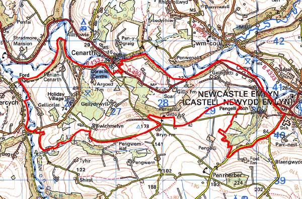
GRID REFERENCE: SN277407
AREA IN HECTARES: 730
Historic Background
This is a medium-sized historic landscape character area within modern Carmarthenshire on the southern slopes of the Teifi Valley. The area lies within the medieval Cantref Emlyn, in Emlyn Uwch-Cych commote. Cantref Emlyn had been partly brought under Anglo-Norman control in c.1100 Numerous castles were established in Uwch-Cych - none of which has any recorded history - but the commote was back under Welsh control by the 1130s, where it remained throughout the 12th and early 13th centuries. It was appropriated by the Anglo-Norman Marshal Earls of Pembroke in 1223, but was granted to Maredudd ap Rhys, with whose family it remained until finally annexed by the English crown in 1283. In 1536 it formed part of the Hundred of Elvet in Carmarthenshire. This fertile area appears always to have been more settled than other parts of Uwch-Cych, and further subdivisions of the commote - possibly in existence before 1100 - have been recorded. The historic landscape character area appears to correspond with one of these - Gwestfa Cilfawr.It may be that Gwestfa Cilfawr, with its possible centre at Gillo Farm (ie. ‘Cilfawr’), formed the basis of the later Gellydywyll estate. It was the only Gwestfa recorded in Cantref Emlyn, which itself may be significant.
Gelldywyll was by the late 15th century in the possession of a local gentry family, the Lloyds. The Lewes family acquired it in 1589. Thus it appears always to have been a separate holding from the rest of Uwch-Cych commote, which having been granted to royal favourite Sir Rhys ap Thomas in the late 15th century, eventually passed by marriage to the Vaughans’ Golden Grove Estate. Moreover Gellydywyll, traditionally, has a long history that is part of Welsh legend, reputedly having been the home of an early chieftain whose horse was said to have been shod with golden shoes. It was laid out as a gentry estate, around the house at Gellydywyll, during the 18th century and a map of ‘Gelli Dowill Demesne’ drawn in 1768, when it was owned by James Lewes, shows a small, laid-out estate with woodland, parkland and shelter-belts. The surrounding field system is similar to today’s. Other estate maps of the 18th century, and the tithe map of 1840, also show a landscape as today. Gellydywyll itself passed to the Golden Grove Estate, through purchase, in the late 19th century. The A484, which runs through this area, began as a turnpike road newly built new in the late 18th century. Twentieth century developments include a holiday village at Penlan and a sewage works, to the west of Gellydywyll.
Description and essential historic landscape components
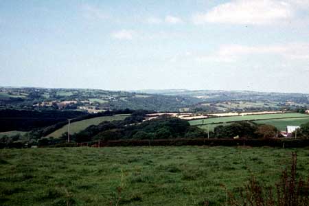
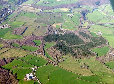
Gellydywyll occupies fairly steep north-facing slopes, rising from 20m above sea level on the floodplain of the Afon Teifi to over 170m. Deciduous woodland on some of the steeper slopes and tributary valley sides, and conifer plantations on pockets of higher ground are a characteristic of this area. Improved pasture with a little arable is, however, the main land-use type. Well-maintained hedges on earth banks surround the medium–sized irregular fields. The strong estate presence, which spanned the 17th century through to the 19th century, is not generally reflected in the landscape, apart from some buildings described below. Dispersed farms dominate the settlement pattern, with a little dispersed linear development along the A484 which runs through the northern part of this landscape close to the Teifi floodplain. There is a small holiday village of chalets, Penlan, close to the same road. Buildings are mostly 19th century in date; with Teifi valley slate the dominant building material. This is frequented cement rendered on dwellings, but left bare on farm buildings. Finely coursed cut stone is common on the estate buildings and randomly laid rubble commonon other structures. Farms are generally quite small, with farmhouses in the typical southwest Wales style – two storey and three-bay with a central front door and five symmetrically arranged windows –a style that owes more to the polite Georgian tradition than the vernacular. They have one or two ranges of stone-built 19th century agricultural buildings, including cowhouses, barns and stables, indicating a mixed farming economy in the 19th century. In some cases these older farm buildings have been converted to non-agricultural uses. Working farms have substantial ranges of modern concrete, steel and asbestos agricultural buildings. Little formality is present in the layout of the farmyards. Gelligatti is an exception. Here a substantial house built for the agent of the Cawdor estate has high quality Victorian model farm buildings attached to it. All are listed. Estate influence on other buildings is not obvious, apart from the late 18th century mansion at Gellydywyll, at least one late 19th century ‘pattern book’ design house close to the A484, and the listed Old Vicarage. Other buildings on this road include19th century worker houses, mid 20th century social housing and dispersed late 20th century housing. Further examples of this latter type can be found dispersed across the area. Most of the 30 archaeological sites recorded in this area are related to the buildings mentioned above or to minor modern historic landscape components such as old quarries. However, a prehistoric chambered tomb indicates a long period of human activity in the landscape.
This is a fairly well defined historic landscape character area as to the north lies the floodplain of the Teifi and the village of Cenarth, to the west the Cych valley, to the east Newcastle Emlyn and to the south, higher and more sparsely settled land.
Sources: Cadw – database of Building of Special
Architectural or Historic Interest; Carmarthen Record Office c/v 5885
Newcastle Emlyn Estate – The Property of John Vaughan 1778, map
2, 5, 7, 9 11; Carmarthen Record Office 227 Maps of the Estates of James
Lewis 1768 pages 3, 11, 17; Cenarth parish tithe map 1840; Craster, O
E, 1957, Cilgerran Castle, London; Jones, F, 1997, Historic Carmarthenshire
Homes and their Families, Carmarthen; Lewis, S, 1833, A Topographical
Dictionary of Wales 1 & 2, London; Lloyd, J E, 1935, A History of
Carmarthenshire, Volume I, Cardiff; Rees, W, 1932, ‘Map of South
Wales and the Border in the XIVth century’; Rees, W, 1951, An Historical
Atlas of Wales, London; Regional Historic Environment Record housed with
Dyfed Archaeological Trust
Base map reproduced from the OS map with the permission
of Ordnance Survey on behalf of The Controller of Her Majesty's Stationery
Office, © Crown Copyright 2001.
All rights reserved. Unauthorised reproduction infringes Crown Copyright
and may lead to prosecution or civil proceedings. Licence Number: GD272221