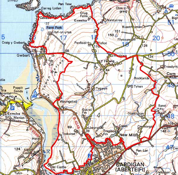
Home > Historic Landscape Characterisation > Lower Teifi Valley > |

 FERWIG
GRID REFERENCE: SN180487
AREA IN HECTARES: 1186
Historic Background
This is a medium-large historic landscape character area within modern Ceredigion, comprising undulating agricultural land between Cardigan town and the rocky cliffs of the Irish Sea. The highest ground is in the north of the area where a Bronze Age round barrow at Crug Farm, attests early occupation in this area and is a prominent feature within the landscape.
The area lay within the medieval Cantref Iscoed, in the commote of Is-Hirwern. Ceredigion, including Cantref Iscoed, was briefly brought under Anglo-Norman control between 1110 and 1136, under the de Clare earls, who built a castle at Cardigan on a hillock overlooking the Teifi. A castle had already been established during an earlier incursion, in 1093, but was short-lived. Anglo-Norman control in Iscoed was brought to an abrupt end in 1136, when Welsh forces won a decisive victory at Crug Mawr, 3km northeast of the town and just beyond the east side of this character area. Ceredigion remained in Welsh hands throughout the 12th and 13th centuries, until finally annexed by the English Crown in 1283, when the county of Cardiganshire was created. However, Is-Hirwern Commote, was relinquished to the Norman King John in 1201 when it became a royal lordship, administered from Cardigan Castle, which it remained until the Act of Union of 1536 when it became part of the Hundred of Troedyraur. The lordship mainly remained subject to Welsh law and tenurial patterns throughout the medieval period, and administered as a ‘Welshry’.
This particular area lay within a division of the commote, Gwestfa Berwick/Ferwig, which may have pre-Norman origins, and persisted into the post-1110 period as a vill, Berwick. This vill may not have been closely associated with Ferwig parish church, St Pedrog’s (which was listed, as the church of ‘Ber[e]wick’ in 1291)as the present settlement around the church is entirely 19th and 20th century. The church may have been founded by the then Welsh Lord of Cardigan in c.1200, when it was granted to Talley Abbey. Except for its tower (which was a celebrated landmark during the 16th century, but was demolished as recently as 1968), the church was rebuilt in the late 19th century. The large rectangular churchyard was remodelled in the post-medieval period and is integrated with (and part of?) the surrounding enclosure pattern. The large, fairly regular fields suggest that they are later post-medieval, possibly 18th century, in origin, although some of the enclosure southwest of the church may be earlier. The mill in this area, Felin Bedr, has a name that reflects the church dedication and this too may be earlier, which may suggest it lies on the site of an medieval mill. Crug Farm, to the north, preserves medieval roof timbers and a 17th century interior, but is not a documented site. The 19th and 20th centuries have seen the development of a nucleation around the parish church, with a chapel, Post Office and school, but this appears to have been de novo in the 19th century. Other modern developments include a sewage works and reservoir.
In contrast, the southern half of this area from the 13th century was embraced within the liberty of the medieval Borough of Cardigan and was held under Anglo-Norman tenure. Cardigan received its first charter in 1284, but had had a weekly market, and burghal privileges, since the mid 12th century. The borough was incorporated in the early 16th century, with a mayor and corporation, and the grant of further privileges. The name Warren Hill, at the east end of the area, may indicate the presence of the burgesses’ rabbit-warren. The Afon Mwldan flows through this area, which supplied three water-mills within the town, and a further three were located within this area. Felin Ganol may occupy the site of one of them, but New Mill appears to be a later establishment. On the tithe map of 1846, strips north of the town indicate relict open fields, but these have now gone. The map also shows a small pocket of common nearby, at Trebared. Otherwise the field system is not unlike that around Ferwig today and appears later post-medievalin origin, suggesting that the open field system was never extensive and that unenclosed land predominated.
There is little later development within this area and most farmhouses appear to date to the second half of the 19th century or 20th century. The area is bounded, to the south, by the A487(T) which was the medieval Cardigan-Aberystwyth route, and had been turnpiked before 1833. A sand pit was worked during the 19th century at Maesymeillion, while there is a pump house at Caemorgan. The 20th century has seen some development around New Mill and Llwynpiod, but otherwise this is an entirely pastoral area.
Description and essential historic landscape components
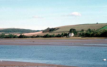
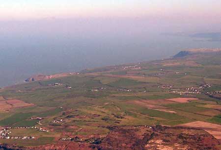
Ferwig historic landscape character area lies on the northern side of the Teifi estuary on gently sloping west-facing slopes rising from the water to over 120m above sea level. The northern end is exposed to Atlantic gales and is therefore treeless. Deciduous woodland is present in more sheltered locations alongside the river opposite St Dogmaels, and on the steep slopes of small valleys. It is an agricultural landscape dominated by improved pasture with a little arable and scrubby rough ground on some steep slopes. Hedges set on earth- and earth-and-stone banks surround the medium-sized fairly regular fields. Hedges are generally well maintained, but in the more exposed locations they are low and in extreme cases they are reduced to windswept lines of gorse and thorn. Teifi valley stone, frequently cement rendered on houses, is the principal pre-20th century building material. Dispersed farms with clustering at Ferwig and Llwynpiod characterised the settlement pattern. In common with other agricultural areas of the lower Teifi valley the older building stock is chiefly 19th century. Crug Farm, with its medieval roof timbers and 17th century interior, is a rare survivor from an earlier period. Ferwig parish church was entirely rebuilt in the late 19th century, except for its tower, which was demolished in the mid 20th century. Georgian-style country houses such as Bryn-y-Mor and Aberdare (both listed) are present, but most farmhouses are more modest, date to the second half of the 19th century and are of two storeys and three bays with examples in both the Georgian style and the vernacular tradition. Stone-built 19th century farm buildings are relatively small, reflecting the size of the land holding, and usually of one or two ranges, some are falling into disuse and others have been converted to non-agricultural use. Working farms have ranges of modern agricultural buildings, but these are not generally substantial. Round-headed corrugated iron barns of probable mid 20th century date survive on some farms. The replacement of a number of older farmhouses with 20th century houses is feature of this area. There is also a significant amount of modern housing, both dispersed and in clusters as at Ferwig and Llwynpiod. As well as modern housing at Ferwig, there a small nucleation of 19th century worker houses – short terraces and detached – focused on the parish church and 19th century chapel. Most of the 28 recorded archaeological sites are concerned with aspects of the post-medieval landscape. Significant earlier sites include the earthwork at Old Castle Farm, and a Bronze Age round barrow and standing stone.
This is a well-defined area to the west and south, but less so to the north and east – here there is a zone of change rather than a hard-edged boundary.
Sources: Cadw – database of Building of Special
Architectural or Historic Interest; Ferwig parish tithe map 1839; Jones,
F, 2000, Historic Cardiganshire Homes and their Families, Newport; Lewis,
S, 1833, A Topographical Dictionary of Wales 1 & 2, London; Ludlow,
N, 2000, ‘The Cadw Welsh Historic Churches Project: Ceredigion churches’,
unpublished reports by Dyfed Archaeological Trust; Meyrick, S R, 1810, The History
and Antiquities of Cardiganshire, London; Owen, E, 1893 & 1894 ‘A
Contribution to the History of the Praemonstratensian Abbey of Talley’,
Archaeologia Cambrensis, 10 & 11, Fifth Series; Rees, W, 1932, ‘Map
of South Wales and the Border in the XIVth century’; Rees, W, 1951,
An Historical Atlas of Wales, London; Regional Historic Environment Record
housed with Dyfed Archaeological Trust; St Mary’s Parish tithe map 1846;
Soulsby, I, 1983, The Towns of Medieval Wales, Chichester
Base map reproduced from the OS map with the permission
of Ordnance Survey on behalf of The Controller of Her Majesty's Stationery
Office, © Crown Copyright 2001.
All rights reserved. Unauthorised reproduction infringes Crown Copyright
and may lead to prosecution or civil proceedings. Licence Number: GD272221