Home > Historic Landscape Characterisation > Lower Teifi Valley > |

 COEDMORE
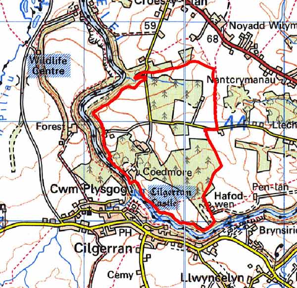
GRID REFERENCE: SN197437
AREA IN HECTARES: 136
Historic Background
Coedmor historic landscape character area lies within modern Ceredigion and corresponds to the 19th century Coedmor Park and its environs, a wooded estate landscape on the undulating plateau north of the Afon Teifi.
During the historic period, this character area lay within Ceredigion, in the medieval Cantref Iscoed, divided between the commotes of Uwch-Hirwern and Is-Hirwern, which were separated by the steep, north-south valley of the Afon Hirwaun. Ceredigion, including Cantref Iscoed, was briefly brought under Anglo-Norman control between 1110 and 1136, under the de Clare earls. It is probably during this period that most of the numerous castles within this this part of Ceredigion were established, some of them possibly having been built during the Welsh reconquest of 1135-6. Ceredigion remained in Welsh hands throughout the 12th and 13th centuries, until finally annexed by the English crown in 1283, when the county of Cardiganshire was created. The cantref, in the main, remained subject to Welsh law and tenurial patterns throughout the medieval period, administered as a ‘Welshry’. However this area - as ‘Coed Mawr’ - formed part of the formal, demesne attached to Cardigan Castle, which had been established by the de Clares by c.1110. In contrast to its environs, Cardigan itself held out against the Welsh until 1164, It was relinquished it to the Norman King John in 1201 when it became the centre of a royal lordship, which corresponded to Is-Hirwern commote. A further period of Welsh rule followed in 1215-1223, but otherwise Cardigan remained in the hands of the English crown for the remainder of the medieval period. So although Coed Mawr may have been constituted as a demesne in c.1110, it was not re-united with the castle until 1201. Demesne was that part of the manor that was the lord’s own land, meaning that it was subject to an Anglo-Norman manorial regime. Normally, demesne land was worked by unfree tenants for 2 or 3 days per week in return for strips of land. However, it could also include forest, waste or woodland, as at Narberth Forest which was part of the demesne attached to Pembroke Castle. The name Coed Mawr suggests that this area too was always wooded and exploited for the economic value of the woodland. Cardigan Castle remained crown property. However, Coed Mawr was apparently farmed out at an early date, and Earl Roger of Chirk was recorded as holding the manor during the late 13th century.
Little is known of the later medieval and early modern history of Coedmore. It formed part of the estates of the Mortimer family, who sold it to Sir John Lewis in 1614-15. It eventually passed into the Lloyd family of Cilgwyn. In 1813, it was described as ‘nothing very remarkable’, but by 1833, under the ownership of Thomas Lloyd, it had become a ‘noble mansion’. It seems likely that the surviving gardens and parkland were laid out by Thomas Lloyd.
Description and essential historic landscape components
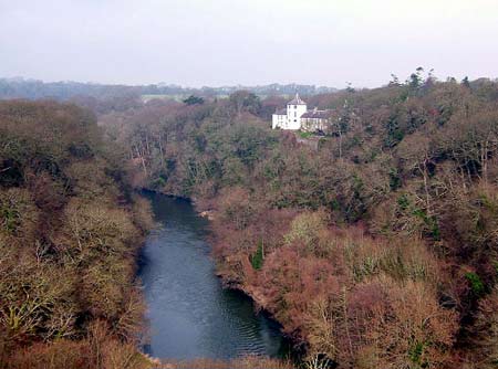
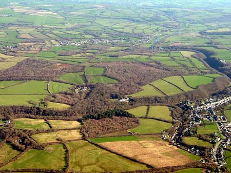
Coedmore is an estate-dominated historic landscape character area lying on the north side of the Afon Teifi. Most of this area lies on gently undulating land between 40m and 60m above sea level edged to the west and south by the very steep wooded slopes of the Teifi gorge. Coedmore House, a substantial early 19th century Georgian style listed house of Teifi valley slate with a later 19th century octagonal tower and large service wing, lies at the heart of this area. Gardens lie around the house, wooded pleasure gardens beyond these to the northwest, and a walled kitchen garden further to the northwest. Included is the home farm with some of its farmland. Fields are relatively large and regular and bounded by well-maintained hedges on earth banks. Agricultural land-use is improved pasture. However, many of the fields have been planted with coniferous trees intermixed with a little deciduous woodland, which may be relict. It is this woodland that is the main characteristic of this area outside the parkland. There is no recorded archaeology in this area apart from those sites associated with Coedmore House and gardens.
Parkland and woodland distinguish this area from its neighbouring areas of farmland and from the Teifi gorge to the south and west.
Sources: Cadw – database of Building of Special
Architectural or Historic Interest; Cadw 2002, Register of Landscapes,
Parks and Gardens of Special Historic Interest in Wales, Part 1 Parks
and Gardens, Carmarthenshire, Ceredigion & Pembrokeshire; Jones, F,
2000, Historic Cardiganshire Homes and their Families, Newport; Lewis,
S, 1833, A Topographical Dictionary of Wales 1 & 2, London; Llechryd
parish tithe map 1842; Llangoedmor parish tithe map 1839; Meyrick, S R,
1810, The History and Antiquities of Cardiganshire, London; Murphy, K,
and O’Mahoney, C, 1985, ‘Excavation and Survey at Cardigan
Castle’, Ceredigion 10, No. 2, 189-218; Rees, W, 1932, ‘Map
of South Wales and the Border in the XIVth century’; Rees, W, 1951,
An Historical Atlas of Wales, London; Regional Historic Environment Record
housed with Dyfed Archaeological Trust
Base map reproduced from the OS map with the permission
of Ordnance Survey on behalf of The Controller of Her Majesty's Stationery
Office, © Crown Copyright 2001.
All rights reserved. Unauthorised reproduction infringes Crown Copyright
and may lead to prosecution or civil proceedings. Licence Number: GD272221