Home > Historic Landscape Characterisation > Lower Teifi Valley > |

 AFON TEIFI: CENARTH - NEWCASTLE EMLYN
GRID REFERENCE: SN284413
AREA IN HECTARES: 105
Historic Background
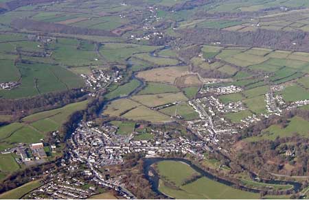
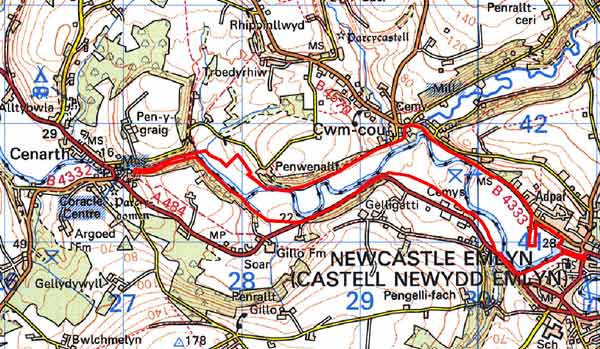
A small, narrow area within modern Carmarthenshire and Ceredigion, comprising the rich, scenic floodplain of the lower Afon Teifi between Cenarth to the west and Newcastle Emlyn to the east. It is entirely farmland, consisting of fairly large, regular fields of pasture. The Teifi forms the boundary between the two counties but the medieval and later history of the area is similar in both. Both Cantref Emlyn (Emlyn Uwch-Cych commote) south of the river, and Cantref Is Aeron (Iscoed commote) north of the river remained in Welsh hands until the 13th century, with a brief period of Anglo-Norman control - and the establishment of numerous castles - between 1100 and 1136. Both areas were finally annexed by the English crown in 1283, when the county of Cardiganshire was created. Emlyn Uwch-Cych commote eventually formed part of the Hundred of Elvet in Carmarthenshire, in 1536. Welsh tenurial patterns - with neither vills nor knight’s fees - have been largely responsible for the dispersed settlement within the region. This and periodical flooding have militated against any settlement within this area where human intervention is limited to field boundaries, drainage ditches and a possible prehistoric chambered tomb. The landscape had assumed its present form by the late 18th century, when estate maps show it as it is today. However, it would have been more isolated than today during the historic period, as the two roads that now flank the floodplain - the A484 on the south side and the B4333 to the north - are both former turnpike roads that were newly constructed in the late 18th century.
Description and essential historic landscape components
This area consists entirely of the floodplain of the Afon Teifi between Cenarth and Newcastle Emlyn, a distance of approximately 4km. The floodplain is generally between 250m and 400m wide, but at the western end above Cenarth Falls it narrows down to the width of the river. It lies at a height of 20m above sea level. Land-use is dominated by improved pasture. Fields are medium- to large-size and are bounded by hedges. These are either on very low banks on no banks. Drainage ditches flank some. Many of the hedges are overgrown, and these together with the numerous hedgerow trees lend a parkland appearance to the landscape. The B4333 to the north and the A484 to the south flank the floodplain for parts of their courses. There are no buildings, and the only recorded archaeology is the possible site of a Neolithic chambered tomb.
The absence of building and the flat nature distinguish this area from the rolling farmland of its neighbours.
Sources: Carmarthen Record Office c/v 5885 Newcastle
Emlyn Estate – The Property of John Vaughan 1778, map 2; Cenarth
parish tithe map 1840; Lewis, S, 1833, A Topographical Dictionary of Wales
1 & 2, London; Llandygwydd parish tithe map 1842; Lloyd, J E, 1935,
A History of Carmarthenshire, Volume I, Cardiff; Meyrick, S R, 1810, The
History and Antiquities of Cardiganshire, London; Rees, W, 1932, ‘Map
of South Wales and the Border in the XIVth century’; Rees, W, 1951,
An Historical Atlas of Wales, London; Regional Historic Environment Record
housed with Dyfed Archaeological Trust
Base map reproduced from the OS map with the permission
of Ordnance Survey on behalf of The Controller of Her Majesty's Stationery
Office, © Crown Copyright 2001.
All rights reserved. Unauthorised reproduction infringes Crown Copyright
and may lead to prosecution or civil proceedings. Licence Number: GD272221