Home > Historic Landscape Characterisation > Drefach-Felindre > |

 COED MAWR
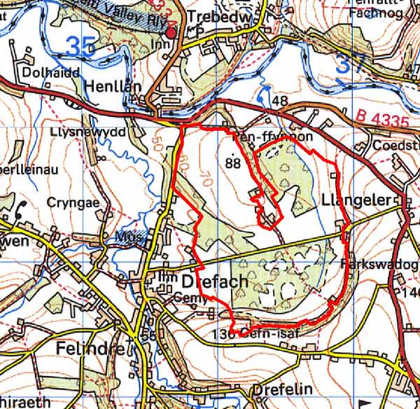
GRID REFERENCE: SN363392
AREA IN HECTARES: 140
Historic Background
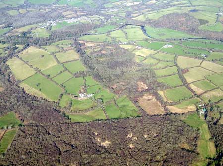
A small area within modern Carmarthenshire comprising a pocket of 19th century Parliamentary enclosure, with regular rectangular fields, now mainly wooded. The area lay within the medieval Cantref Emlyn, in Emlyn Uwch-Cych commote. Cantref Emlyn had been partly brought under Anglo-Norman control in c.1100. Numerous castles were established in Uwch-Cych - none of which has any recorded history - but the commote was back under Welsh control by the 1130s, and remained such throughout the 12th and early 13th centuries. It was appropriated by the Anglo-Norman Marshal Earls of Pembroke in 1223, but was granted to Maredudd ap Rhys, with whose family it remained until finally annexed by the English crown in 1283. It eventually formed part of the Hundred of Elvet in Carmarthenshire, in 1536. Uwch-Cych was granted to royal favourite Sir Rhys ap Thomas in the late 15th century, reverting to the crown in 1525 to be granted, in 1546, to Sir Thomas Jones of Haroldston, Pembrokeshire. It remained in this family for several generations, eventually passing by marriage to the Vaughans’ Golden Grove Estate, which in the 19th century still owned almost all the land on the southern side of the Teifi from Pentre-cwrt in the east to Cenarth in the west. The medieval Welsh tenurial pattern - with neither vills nor knight’s fees - has been largely responsible for the dispersed settlement within the region. Indeed little settlement has occurred within this area, which during the post-medieval period, and probably earlier, was common land. On the 1839 tithe map this area is depicted as open unenclosed land, and named on the accompanying apportionment as Waun Fawr Common, in the ownership of Earl Cawdor. The tithe map evidence suggests that the fringes of this common had recently been encroached upon and enclosed. In 1855, a Parliamentary Enclosure Award was granted for 138 acres of common and waste, then called Waunmeiros. The outcome of this award – regularly shaped fields and a straight section of road - is shown on the First Edition Ordnance Survey map surveyed in 1887. The field pattern established in 1855 prevails today. A small woodland plantation was established by 1887, and today land is under.a mixture of woodland and pasture.
Description and essential historic landscape components
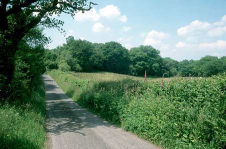
This relatively small historic landscape area, lying across gently undulating ground between 60m and 89m, is not now greatly different from its neighbouring landscapes, but it has a distinct and well-documented recent landscape history. The current pattern of regular, relatively small fields separated by hedges on earth banks dates from 1855, following a Parliamentary Enclosure Act. A straight section of road crossing the area is typical of Parliamentary enclosure. A small deciduous plantation was established by 1887 and subsequently many other fields have reverted to or have been planted with deciduous woodland. This woodland and the overgrown nature of the hedges lends a heavily wooded aspect to the landscape. Land quality does not appear as good as that in neighbouring areas as there is much unimproved pasture and damp rushy ground. There are no dwellings or other buildings, and no recorded archaeological sites.
Regular fields, woodland and the absence of buildings distinguish this area from its neighbours. Apart from these elements, the general landscape character is not dissimilar from the rest of this part of rural north Carmarthenshire.
Sources: Chapman, J, 1992, A Guide to Parliamentary
Enclosures in Wales, University of Wales Press, Cardiff; Craster, O E,
1957, Cilgerran Castle, London; Lewis, S, 1833, A Topographical Dictionary
of Wales 1 & 2, London; Llangeler tithe map, 1839; Lloyd, J E, 1935,
A History of Carmarthenshire, Volume I, Cardiff; Ordnance Survey 1:2500
First Edition, c.1880; Rees, W, 1932, ‘Map of South Wales and the
Border in the XIVth century’; Rees, W, 1951, An Historical Atlas
of Wales, London; Regional Historic Environment Record housed with Dyfed Archaeological Trust
Base map reproduced from the OS map with the permission
of Ordnance Survey on behalf of The Controller of Her Majesty's Stationery
Office, © Crown Copyright 2001.
All rights reserved. Unauthorised reproduction infringes Crown Copyright
and may lead to prosecution or civil proceedings. Licence Number: GD272221