Home > Historic Landscape Characterisation > Drefach-Felindre > |

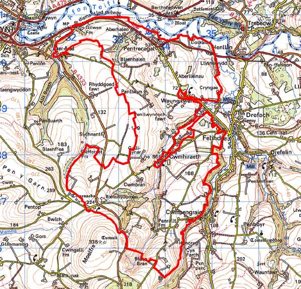
 BWLCHYDOMEN - PENTRECAGAL
GRID REFERENCE: SN334381
AREA IN HECTARES: 1049
Historic Background
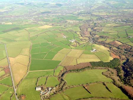
A fairly large area within modern Carmarthenshire consisting of dispersed farms, fields and scattered woodland stands.
It lies within the medieval Cantref Emlyn, in Emlyn Uwch-Cych commote. Cantref Emlyn had been partly brought under Anglo-Norman control in c.1100 when Emlyn Is-Cych commote to the west was reconstituted as the Lordship of Cilgerran. Numerous castles were established in Uwch-Cych comote - none of which has any recorded history - but the commote was back under Welsh control by the 1130s, where it remained throughout the 12th and early 13th centuries. A motte-and-bailey castle, ‘Tomen Seba’, was established within this character area. It has no recorded history and it is not known whether it belongs to the brief period of Anglo-Norman control, or was a Welsh foundation of the later 12th century. If it was Anglo-Norman, it is likely that it fell into disuse at an early date, and it never became the focus for any later settlement, nucleated or otherwise.
Uwch-Cych commote was appropriated by the Anglo-Norman Marshal Earls of Pembroke in 1223, but was granted to Maredudd ap Rhys, with whose family it remained until finally annexed by the English crown in 1283. In 1536 it formed part of the Hundred of Elvet in Carmarthenshire. Uwch-Cych was granted to royal favourite Sir Rhys ap Thomas in the late 15th century, reverting to the crown in 1525, to be granted in 1546 to Sir Thomas Jones of Haroldston, Pembrokeshire. It remained in this family for several generations, eventually passing by marriage to the Vaughans’ Golden Grove Estate, which in the 19th century still owned almost all the land on the southern side of the Teifi from Pentre-cwrt in the east to Cenarth in the west. The medieval Welsh tenurial pattern – with neither vills nor knight’s fees - has been largely responsible for the dispersed settlement within the region.
Late 18th century estate maps show a few intermixed, unenclosed field strips on some holdings. However, they are probably not medieval in origin, and are certainly not the formal, arable open field strips characteristic of Anglo-Norman tenure. Instead, the strips appear to represent grazing rights assigned to neighbouring farms and it would seem that at least part of this area was open land, under multiple-ownership grazing, which underwent enclosure in the late 18th century. The present landscape, throughout the character area, mainly comprises medium-sized, fairly regular fields which, in shape and size, are characteristic of the earlier post-medieval period. Late 18th century estate maps show a landscape that is, except for the remnant field strips, similar to that of today. By the time the tithe map was drawn up in 1840 all these strips had gone. The tithe map also shows two small pockets of open land, Waungilwen Common and Cwmhiraeth Common. These are probably the remnants of unenclosed grazing land. This common land had presumably been extensive in earlier centuries, but had been enclosed piecemeal until virtually nothing remained by the mid 19th century. An Act of Parliament enclosed these last remnants in 1866. The only settlement cluster is at Pentrecagal, alongside the A484 at its junction with the unclassified road to Drefach-Felindre. It appears to be 19th century in origin, developing after the A484 had been built as a turnpike, in the late 18th century, in response to increasing traffic to and from woollen mills. The area lies beyond the main textile-producing area of the 19th century, but there are records of weavers at several locations within the area, presumably operating a cottage industry in cottages or small workshops. This industry had ceased by the mid 20th century.
Description and essential historic landscape components
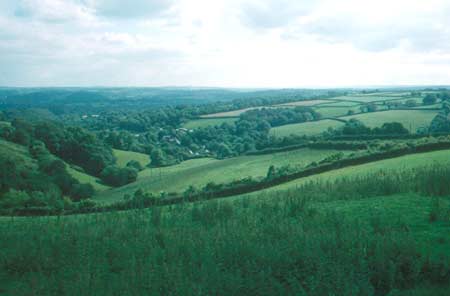
Dispersed farms, fields surrounded by hedges and small pockets of deciduous woodland characterise this agricultural historic landscape character area. It lies on the gently-sloping north-facing valley side of the Afon Teifi. At its northern end it merges with the floodplain of the river at about 30m above sea level, but at its southern extremes it rises to over 260m above sea level. Agricultural land-use is almost entirely improved pasture, with very little arable or rough ground. Fields are medium-sized and irregular and are bounded by earth banks topped with hedges. Hedges are generally well maintained, but with a tendency to become straggling and overgrown at the higher more exposed southern borders, and lusher with more trees and larger bushes at lower, sheltered elevations. Woodland is mainly confined to the steeper valley sides of minor streams. This limited woodland together with overgrown hedges lends a wooded aspect to parts of the landscape. Stone is the chief building material, either cement-rendered or left bare. At the southern end of the area, away from the Teifi, locally-sourced stone is used. This is often rendered where used in housing, but left bare on agricultural outbuildings. Closer to the river Teifi valley slate dominates. Commercial, north Wales slate is the ubiquitous roofing material. The main building stock is 19th century, with most farmhouses probably dating to the latter half of the century, modest in size and in the typical southwest Wales style – two storey and three-bay with a central front door and five symmetrically arranged windows –a style that owes more to the ‘polite’ Georgian tradition than the vernacular. Nineteenth century farm outbuildings are likewise quite small, generally of one or two ranges, with cowhouses, stables and barns on most farms. Modern outbuildings, in the main, are not large although some very large examples are present. Some late 19th century workers’ houses, single-storeyed and two-storeyed, are dispersed close to the boundary of the Drefach – Felindre woollen industrial area. Pentrecagal, the only settlement cluster, consists of some late 19th century worker houses and late 20th century housing spreading along the A484. Worker houses, a public house, a petrol station and other low-key commercial developments lie alongside this main road to the west of Pentrecagal. Dolhaidd Mansion, a listed 19th century ‘Georgian’ building with earlier elements, is the largest building in this area. Its Home Farm, where some of the buildings have been converted to holiday use, lies a little distance from the mansion. Most of the 63 archaeological sites record the use of a cottage or dwelling for weaving or other small-scale use associated with the 19th century woollen industry. The only other major, earlier archaeological sites are Tomen Seba - a medieval motte castle - and an Iron Age hillfort.
Bwlchydomen – Pentrecagal historic landscape character area is well-defined to the north where it borders the Teifi floodplain, to the east against the industrial villages of Drefach – Felindre, and to the south where it runs up against the higher, formerly unenclosed land. Definition is less satisfactory to the west where the landscape shares many similar components to that of Bwlchydomen – Pentrecagal.
Sources: Cadw – database of Building of Special
Architectural or Historic Interest; Carmarthen Record Office c/v 5885
Newcastle Emlyn Estate – The Property of John Vaughan 1778, maps
43, 47, 51, 54, 58, 62, 64; Craster, O E, 1957, Cilgerran Castle, London;
Jones, D E, 1899, Hanes Plwyfi Llangeler a Phenboyr, Llandysul; King,
D J C, 1988, Castellarium Anglicanum, New York; Lewis, S, 1833, A Topographical
Dictionary of Wales 1 & 2, London; Lloyd, J E, 1935, A History of
Carmarthenshire, Volume I, Cardiff; Ludlow, N, 2002, ‘The Cadw Early
Medieval Ecclesiastical Sites Project, Stage 1: Carmarthenshire’,
unpublished report by Dyfed Archaeological Trust; Penboyr parish tithe map 1840;
National Library of Wales Rev J C Davies Map Book 1793-1815; National
Library of Wales Ms Vol 84 (PE965) Plan of Llangeler, Penboyr and Kilrhedin
Inclosure 1866; Ramsey, R and Ludlow, N, 1999, ‘Blaen Bowi, Cenarth:
proposed windfarm site, archaeological assessment’, unpublished
report by Dyfed Archaeological Trust; Rees, W, 1932, ‘Map of South Wales
and the Border in the XIVth century’; Rees, W, 1951, An Historical
Atlas of Wales, London; Regional Historic Environment Record housed with
Dyfed Archaeological Trust
Base map reproduced from the OS map with the permission
of Ordnance Survey on behalf of The Controller of Her Majesty's Stationery
Office, © Crown Copyright 2001.
All rights reserved. Unauthorised reproduction infringes Crown Copyright
and may lead to prosecution or civil proceedings. Licence Number: GD272221