Home > Historic Landscape Characterisation > Drefach-Felindre > |

 BWLCH-CLAWDD - CWMBACH
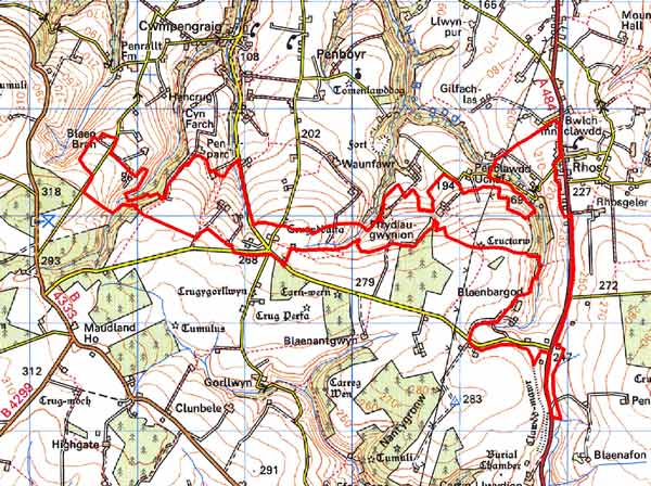
GRID REFERENCE: SN378345
AREA IN HECTARES: 270
Historic Background
This is a small area within modern Carmarthenshire, comprising a narrow strip on the northern flank of an east-west ridge. It comprises 18th - 19th century enclosure of open moorland. In common with similar landscapes elsewhere in southwest Wales, prehistoric monuments represent the main historic landscape component. Crugyddalfa and Cructarw, two Bronze Age burial mounds on its southern fringe - both of which were intentionally highly visible - give visual character and time-depth to the landacape character area. No contemporary field systems have so far been recognised. During the historic period, the area lay on the southern edge of the medieval Cantref Emlyn, in Emlyn Uwch-Cych commote. Emlyn had been partly brought under Anglo-Norman control in c.1100 when Emlyn Is-Cych commote, to the west, was reconstituted as the Lordship of Cilgerran. Numerous castles were established in Uwch-Cych - none of which have any recorded history - but the commote was back under Welsh control by the 1130s, and remained such throughout the 12th- and early 13th centuries. It was appropriated by the Anglo-Norman Marshal Earls of Pembroke in 1223, but was granted to Maredudd ap Rhys, with whose family it remained until finally annexed by the English crown in 1283. In 1536, it eventually formed part of the Hundred of Elvet in Carmarthenshire,, when Is-Cych joined Pembrokeshire. Uwch-Cych was granted to royal favourite Sir Rhys ap Thomas in the late 15th century, reverting to the crown in 1525, and was granted in 1546 to Sir Thomas Jones of Haroldston, Pembrokeshire. It remained in this family for several generations, eventually passing by marriage to the Vaughans’ Golden Grove Estate, which in the 19th century still owned almost all the land on the southern side of the Teifi from Pentre-cwrt in the east to Cenarth in the west. The medieval Welsh tenurial pattern - with neither vills nor knight’s fees - has been largely responsible for the dispersed settlement within the region. Indeed, this character area was probably open moor until the mid 18th century. Its subsequent history is relatively well understood. Estate maps of 1778 show partially enclosed moorland. To its north lay farms and fields as today, and to the south open, high moor. Colonisation took place. For instance, at Penclawdd Uchaf in 1778 two cottages lay on unenclosed moor, but by 1839 fields had been created around these cottages. This colonisation of common, squatter settlements or tai unnos, was of dubious legality, but often tolerated. When Act of Parliament enclosed the remaining common of Llangeler and Penboyr in 1866 some of these settlements are marked as encroachments. Since that date there has been some retreat of settlement.
Description and essential historic landscape components
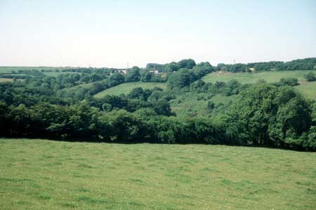
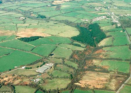
Bwlch-Clawdd – Cwmbach is a linear, east to west aligned, historic landscape character area lying on north-facing slopes between 210m and 270m immediately below a ridge summit. It is an agricultural character area characterised by small irregular fields, hedges on banks and dispersed farms. Agricultural land-use is almost entirely improved pasture, with little arable or poor quality land. Hedges on the earth and earth/stone banks are generally overgrown and straggling, and the many large bushes and small trees in them, in combination with deciduous woodland on some of the steep valley sides, provides a wooded aspect to parts of the landscape. Agricultural holdings are very small. Late 20th century bungalows and two-storey houses in a variety of styles and materials have replaced most of the earlier farmhouses, and there is some dispersed modern housing across the area. Occasional late 19th century cement rendered two storey vernacular dwellings survive, but are rare. Stone-built 19th century farm buildings are likewise unusual, and where they do occur they are small. Most farm outbuildings are modern and relatively small, although one farm has very substantial late 20th century steel, concrete and asbestos agricultural buildings. There are no listed buildings. Thirteen archaeological sites are recorded. Most of these are either quarries and sand pits of the 19th century and 20th century or buildings mentioned above. Two Bronze Age burial mounds demonstrate pre-19th century human activity in the area, as does the northern end of Clawdd-Mawr, an early medieval linear defensive earthwork.
This is a relatively well-defined historic landscape character area. Regular fields created by a 19th century enclosure award lie to the south and richer, larger farms on the lower-lying land to the north.
Sources: Carmarthen Record Office c/v 5885 Newcastle
Emlyn Estate – The Property of John Vaughan 1778, maps 70, 85, 89,
92; Craster, O E, 1957, Cilgerran Castle, London; Jones, D E, 1899, Hanes
Plwyfi Llangeler a Phenboyr, Llandysul; Lewis, S, 1833, A Topographical
Dictionary of Wales 1 & 2, London; Llangeler parish tithe map 1839;
Lloyd, J E, 1935, A History of Carmarthenshire, Volume I, Cardiff; National
Library of Wales Ms Vol 84 (PE965) Plan of Llangeler, Penboyr and Kilrhedin
Inclosure 1866; Penboyr parish tithe map 1840; Rees, W, 1932, ‘Map
of South Wales and the Border in the XIVth century’; Rees, W, 1951,
An Historical Atlas of Wales, London; Regional Historic Environment Record
housed with Dyfed Archaeological Trust.
Base map reproduced from the OS map with the permission
of Ordnance Survey on behalf of The Controller of Her Majesty's Stationery
Office, © Crown Copyright 2001.
All rights reserved. Unauthorised reproduction infringes Crown Copyright
and may lead to prosecution or civil proceedings. Licence Number: GD272221