|

WARPOOL 
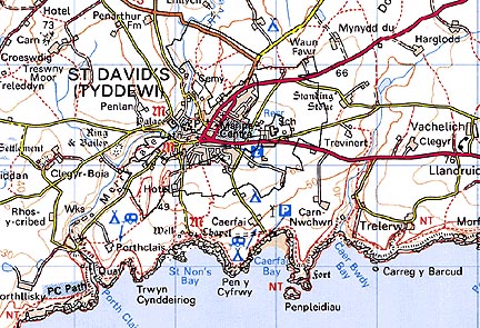
GRID REFERENCE: SM758254
AREA IN HECTARES: 151.5
Historic Background
An area of modern Pembrokeshire within St David’s Peninsula, around
the borough (later a city) of St David’s. It lies within St David’s
parish, in the medieval Cantref Pebidiog or ‘Dewisland’, which
was held directly by the Bishops of St David’s, having represented
the core of the bishopric from 1082 when it was granted (or confirmed)
by Rhys ap Tewdwr, king of pre-Conquest Dyfed, to Bishop Sulien. From
1115, when Bernard was appointed Bishop of St David’s, Anglo-Norman
systems of feudal government and ecclesiastical administration were introduced
into Pebidiog, which was coterminous with the later Hundred of Dewsland
created in 1536. Pebidiog was renowned for its fertile arable land, and
according to the census in George Owen’s Taylor’s Cussion,
it was one of the most densely populated regions of Pembrokeshire in the
16th century, with the most plough teams, and particularly productive
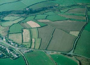
of barley. The Warpool character area comprises the town fields of St
David’s. These arable open field-strips were farmed by the burgesses
of the city and - unlike most of the field systems within St David’s
parish - were held under Anglo-Norman tenure. They are, accordingly, the
long aratrally-curving type associated with ‘typical’ medieval
open-field systems, rather than the shorter lleinau (or shares) seen elsewhere
on the peninsula. A corn windmill, first referred to in 1509, is an indication
of the arable regime. This was situated in the west of the area near the
Porthclais road and was demolished in 1809 when it was replaced by the
present structure southeast of the town. The character area also includes
four small areas of common land associated with the borough. The arable
open-field strips are shown on late 18th-century estate maps, running
down to the coast to the south of the city and continuing to the east
and west. It is not clear from the estate maps whether the strips had
been enclosed or not. By the tithe survey the strips were clearly enclosed,
and close to the coast they had been converted to rectangular fields.
The former name of a track Meidr-y-saint, or ‘Saints’ Lane’
for a deep hollow-way leading north out of the city, descending to the
River Alun which it crosses on an ancient bridge known as Pont-y-penyd
(‘Bridge of Penitence’), is representative of the ecclesiastical
topography of the area. Warpool Court in the south of the area was built
new by a clergyman in c.1865. A world war two machine gun-post, now derelict,
lies close by.
Base map reproduced from the OS map with the permission
of Ordnance Survey on behalf of The Controller of Her Majesty's Stationery
Office, © Crown Copyright 2001.
All rights reserved. Unauthorised reproduction infringes Crown Copyright
and may lead to prosecution or civil proceedings. Licence Number: GD272221
Description and essential historic landscape components
Warpool historic landscape character area comprises a broad band of land
lying to the south, east and north of Tyddewi (St David’s City)
historic landscape area. The land here is gently undulating, lying between
approximately 35m and 75m. Though this area mainly consistes of an enclosed
strip field system - the old open fields attached to St David’s
- 19th- and 20th-century development and the amalgamation of some strips
into rectangular fields has both contracted the extent of this area from
what was quite a wide band of land, and affected its character. Housing
estates, piecemeal housing development, schools and a cemetery on the
fringes of the city now occupy parts of this former area (these have been
incorporated into Tyddewi historic landscape character area). Nevertheless,
enclosed strip fields characterise this area. These are defined by earth
or earth and stone banks topped with hedges. Hedges are low and windswept,
and many are neglected and supplemented with wire, but they do form a
distinctive component of the landscape. A few dry-stone wall field boundaries
are also present. Agricultural land-use is mostly improved pasture, with
a little arable land. Two large buildings, both now hotels - Warpool Court
Hotel and Twr-y-Felin - were established on the former enclosed fields
in the 19th century. Warpool Court is Grade II listed, and is from substantial
house built new in c.1865 but radically remodelled in the 20th century.
Its garden terrace, hemicycle, and archway, all from c.1870, are also
Grade II listed. The windmill from 1809 at Twr-y-Felin, was converted
into a dwelling, now a hotel, and is Grade II listed. Apart from the trees
close to both the hotels, this is a treeless landscape. There are few
other settlements, but of note is a stone-built 19th century ‘villa’
in polite Georgian tradition. There is also a hexagonal, brick, AA machine
gun-post from world war two, now derelict, in the area. Recent development
includes a 1990s industrial estate.
Recorded archaeology is restricted to a standing stone and possible round barrow from the bronze age, and a post-medieval quarry.