|

263 CARN WEN 
GRID REFERENCE: SN166283
AREA IN HECTARES: 17.5
Historic Background
A small character area in modern Carmarthenshire comprising Carn
Wen, a hill to the southeast of Mynydd Preseli. It lay within the medieval
Cwmwd Amgoed, a commote of Cantref Gwarthaf which had been re-organised
as the Anglo-Norman Lordship of St Clears by 1130. However, the area continued
to be held under Welsh systems of tenure throughout and into the post-medieval
period, and by the later middle ages was divided into three blocks of
dispersed holdings - Trayn Morgan, Trayn Clinton, and Trayn March within
which Carn Wen lay. The hill is, and probably always was, unenclosed but
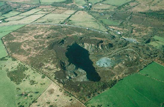
is now almost entirely occupied by a large quarry, now disused. The quarry
may have featured some slate extraction but any evidence has been removed
by more recent excavation for stone.
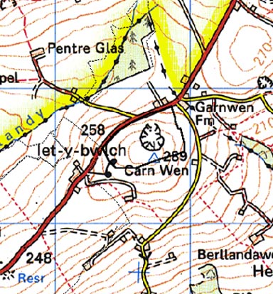
Base map reproduced from the OS map with the permission
of Ordnance Survey on behalf of The Controller of Her Majesty's Stationery
Office, © Crown Copyright 2001.
All rights reserved. Unauthorised reproduction infringes Crown Copyright
and may lead to prosecution or civil proceedings. Licence Number: GD272221
Description and essential historic landscape components
This is a very small historic character area. It consists of a small hill
- Carn Wen - that rises from the surrounding enclosed farmland at 250m
to a maximum of 289m. It is unenclosed and is covered with bracken and
gorse scrub. It is not grazed. A large quarry was worked here until the
late 20th-century. The industrial remains of this quarry provide one of
the main historic landscape components of the area. There are no settlements,
and the only structures are those associated with the abandoned quarry.
The A478 runs along the western boundary of the area.
Recorded archaeology is confined to a bronze age findspot, but the place-name suggests that the summit of the hill was occupied by bronze age cairn(s) which were removed by the post-medieval quarries.
The small unenclosed hill is a well-defined historic landscape character area. It is surrounded by the enclosed farmland of Pentre Galar character area.
Sources: Llanglydwen tithe map and apportionment, 1846; Rees 1932; Richards 1998