|

258 MYNACHLOG-DDU 
GRID REFERENCE: SN 110307
AREA IN HECTARES: 941.8
Historic Background
A large, irregular dispersed area of enclosed land in modern Pembrokeshire,
deeply cut into by the boggy land of the Gors Fawr - Waun Cleddau character
area that occupies the southern flank of Mynydd Preseli. It lay within
the medieval Cantref Cemaes. Caermeini, in the north of the area, has
been identified as one of the possible sites of the Battle of Mynydd Carn
which, in 1081, secured the throne of Dyfed for Rhys ap Tewdwr of the
royal house of Deheubarth - though only for 20 years. Cemaes was brought
under Anglo-Norman control by the Fitzmartins in c.1100, who retained
it, as the Barony of Cemaes, until 1326 when they were succeeded by the
Audleys. Like most of the southeastern part of the Barony within Mynydd
Preseli, the area continued to be held under Welsh systems of tenure.
In 1118 William Fitzmartin granted the whole area, as part of the grange
of Nigra Grangia, to the Tironians of St Dogmaels Abbey. The grange was
of considerable extent, comprising 5 carucates which were worth £8 15s
6d in 1535. However, its assessment at only half a knight's fee suggests
that much of it was probably unenclosed moorland pasture during the medieval
period. The sites of four mills recorded in 1535 are unknown, but Felin
Dyrch may have early origins. At the Dissolution, the grange was acquired
by John Bradshaw of Presteigne, along with St Dogmaels Abbey, and was
thereafter held distinct from the Barony of Cemaes. The Court of Augmentations
records that the lands of the former grange were, in 1538-9, held by copyhold
ie. the tenant's names were entered into a rental book, within which properties
can be identified as the current farmsteads Pantyrhug and Plasdwbwl, and
Cwm Cerwyn and Pentre Ithel which were gentry-houses of some status. Their
entry and description as 'tenements' suggests that some formal enclosure
of the grange had already taken place, and the present pattern of boundaries
within the area is typical of early post-medieval enclosure. However,
a cluster of 'lleini' farm-names, towards the northwest of the area, indicate
a strip field or open field system probably dating from the medieval period.
The enclosure pattern in the eastern half of this character area is similar,
and probably also late-medieval to 16th century in origin. Blaen-banon,
at the far northern end of the area, was recorded as the limit of the
formal common of Mynydd Preseli in a survey of 1594. Seventeenth-century
farmsteads include Dolaumaen to the northeast of the area (which was the
centre of a small estate established by 1786 and comprising 655 acres
by 1840), Glynsaithmaen, and Dyffryn Ffilbro. The present pattern of dispersed
settlement relates to this and later enclosure of former moorland, some
of which, towards the north of the area, may be very late. Charles Hassall's
record, in 1794, of the 'extensive waste' persisting in Mynachlog-ddu
is reproduced in the County History, and two small pockets of enclosure
in this section appear to be to attributable to 18th- and 19th-century
squatting. The present enclosure pattern was complete by the time of the
tithe surveys of the 1840s. Lower Tyrch slate quarry in the centre of
the area - from which County Hall, Carmarthen was roofed - was operational
from the late 18th-century until 1939, and housing for the slate-workers
probably contributed to the development of the nucleation at Mynachlog-ddu
in the 19th- and 20th-century. It was the home of one of the leading Rebecca
Rioters of the 1840s and has a chapel from 1794. The later history of
the area nevertheless continues to be overwhelmingly pastoral.
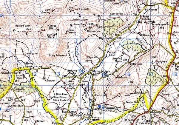
Base map reproduced from the OS map with the permission
of Ordnance Survey on behalf of The Controller of Her Majesty's Stationery
Office, © Crown Copyright 2001.
All rights reserved. Unauthorised reproduction infringes Crown Copyright
and may lead to prosecution or civil proceedings. Licence Number: GD272221
Description and essential historic landscape components
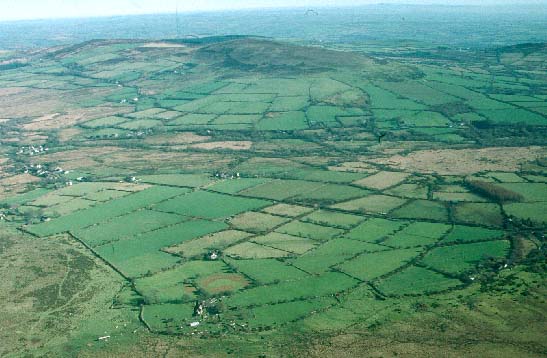
This area consists of several lobe-shaped blocks of enclosed land lying
on the southern flanks of Mynydd Preseli and the slopes of Foel Dyrch,
separated by areas of lower lying marsh and unenclosed grazing. It lies
between 190m and 300m. Land-use predominantly comprises improved pasture,
with a little arable land, though there are patches of rushy-ground and
marsh in low-lying hollows, and unimproved and rough grazing at higher
levels on the fringes of Mynydd Preseli and Foel Dyrch. Farmland is divided
into relatively small, irregular fields, though long, thin enclosures
close to Carnmeini farms suggest the former presence of a strip field
system not mentioned in the 16th century rental. Mixed stone and earth
banks are the most common form of field boundary, but stone-faced banks,
earth banks and, at higher levels on the fringes of Mynydd Preseli, semi-derelict
dry-stone walls are also present. At lower levels hedges top the banks.
Generally these hedges are not in good condition except those alongside
roads and lanes; many have gaps and others are becoming overgrown. Across
most of the area hedges now either consist of straggling lines of bushes
or have entirely gone, particularly at higher levels. Wire fences provide
stock-proof boundaries. Apart from a 20th century coniferous plantation
close to Llwyn-drain farm, there is little woodland in this landscape,
though small trees have grown out of some of the neglected hedges, and
most farms have had trees planted around them for shelter. Clumps of trees
surrounding abandoned farms on high slopes are a feature of this landscape.
Public roads consist of winding lanes flanked by high banks and hedges.
The settlement pattern is one of dispersed agricultural holdings with
a loose clustering of buildings at the village of Mynachlog-ddu. Two chapels
- Capel Bach and Capel Bethel, the latter established in 1794 - and school
are present. As noted above, deserted farms and cottages are a feature
of the landscape, particularly on the more open higher slopes. Older,
extant dwellings are almost entirely 19th century in the vernacular style,
and are generally stone-built with slate roofs, one, one-and-a-half or
two storey, and 3-bays, cement rendered and bare stone. Most are modernised.
It is likely that the cement rendering on some dwellings masks earth-built
structures. Several single-storey mid 20th-century timber-framed corrugated-iron
clad houses are also present. Later 20th-century development is limited
and mostly concentrated in Mynachlog-ddu village. It consists of two storey
houses and bungalows in a variety of styles and materials. Agricultural
buildings are small, reflecting the size of holding. Most common styles
are: a single small, stone-built 19th century range; a mid 20th-century
corrugated-iron barn and other structures; and several small late 20th-century
steel-, concrete- and asbestos-built structures. There are no listed buildings
in the area.
Recorded archaeology is diverse with a high percentage of prehistoric sites. The northern, higher region contains a scheduled, neolithic chambered tomb and another megalithic structure, and from the bronze age, four definite and two possible standing stones, one definite and one possible stone pair and a possible round barrow. It also contains one possible site of the 11th century battle of Mynydd Carn. There is also one definite and one possible medieval pilgrimage chapel site, and two holy well sites. Felin Dyrch mill may have medieval origins. Post-medieval sites comprise quarrying features and a sheepfold.
Mynachlog-ddu, despite its dispersed nature, is a very coherent historic landscape character area. It is divided, separated and bounded to the south and west by lower-lying parcels of marsh and moor of the Gors Fawr - Waun Cleddau character area. To the north there is a very clear boundary between this area and the open land of Mynydd Preseli. Open moorland and semi open moorland of Foel Dyrch and Crugiau Dwy character areas also provide a clear boundary to the east. Only to the southwest where Mynachlog-ddu character area meets Llangolman is there a lack of boundary definition. Here there is a zone of change rather than a hard-edged boundary.
Sources: Charles 1992; Dyfed Archaeological Trust 1997; Howells 1987; Jones 1996; Lewis 1969; Llangolman tithe map and apportionment 1841; Monachlogddu tithe map and apportionment 1846; Pritchard 1907; Rees 1932; Richards 1998.