Home > Historic Landscapes > Black Mountain and Mynydd Myddfai > |

256 CARREG CENNEN CASTLE 
GRID REFERENCE: SN 668190
AREA IN HECTARES: 16.58
Historic Background
A very small character area comprising the rocky hill, and castle, of
Carreg Cennen, in the foothills of the Black Mountain. The cave beneath
the castle was occupied during the prehistoric period, but the history
of the area is primarily Medieval. Much of this section has been taken
from Lewis 1990, Carreg Cennen Castle. Carreg Cennen was, during the historic
period, the administrative centre and llys of Iscennen commote, giving
its name to Maenor Llys within which it lay; its maerdref lay in Area
198 now represented by the farm-names Ferdre Fawr and Fach (Rees 1924,
200). The llys had been established by at least the 13th century and appears
to have been fortified prior to the construction of the present castle
later in that century, possibly under the Prince of Deheubarth Rhys ap
Gruffydd who built castles at Dinefwr (Area 195) and Cardigan in the late
12th century. Along with Cantref Bychan, Carreg Cennen fell to his son
Rhys Gryg but was separated from the rest of Iscennen in 1233 when Rhys
Mechyll succeeded. It was briefly captured by the English in 1248, was
the scene of several changes of hands in the 1250s and finally, in 1277,
surrendered to the English. The castle, along with Iscennen, was acquired
by John Giffard in 1283, and in 1340 it became a member of the Duchy of
Lancaster (Rees 1953, xv-xvi). The castle was rebuilt as a substantial
masonry construction, the present Inner Ward being constructed in the
late 13th century and the Outer Ward being added in the early 14th century.
The castle was captured and damaged during the Glyndwr rebellion, but
was finally destroyed during the Wars of the Roses in 1461. The later
history of the castle is obscure until the late 18th century when its
striking site came to the notice of Romantic painters and poets. It was
acquired by the State in 1932 on whose behalf it is now managed by Cadw.
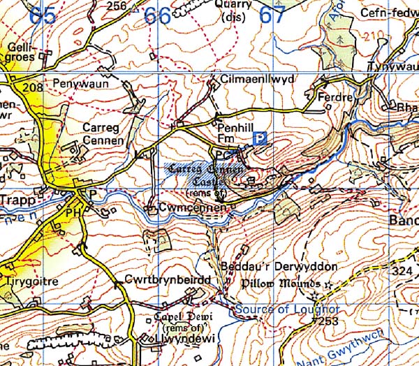
Base map reproduced from the OS map with
the permission of Ordnance Survey on behalf of The Controller of Her Majesty's
Stationery Office, © Crown Copyright 2001.
All rights reserved. Unauthorised reproduction infringes
Crown Copyright and may lead to prosecution or civil proceedings. Licence
Number: GD272221
Description and essential historic
landscape components
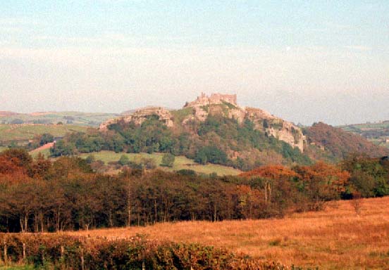
This very small character area consists of the Medieval castle of Carreg
Cennen and the hill on which it is located. Carreg Cennen hill is composed
of Carboniferous limestone and rises from the Cennen valley at approximately
150 m to a summit of over 260 m. The northern, eastern and western flanks
of the hill are steep-sided, the southern and southwestern sides are vertical
cliffs. The lower less precipitous but nevertheless craggy southern slopes
are cloaked with deciduous woodland. The remainder of the hill is improved
pasture. This has been divided into small irregular fields by earth, and
earth and stony banks, both of which are topped with hedges. Carreg Cennen
Castle is, however, the major historic element of this landscape. Substantial
elements of this masonry castle on the summit survive, including most
of the main curtain wall and associated towers. The outer ward is less
well preserved. Included in the remains is a covered passageway which
leads down the cliff-face to a cave. In the Outer Ward lie the remains
of a stone-built limekiln.
Recorded archaeology is dominated by the substantial remains of the Medieval masonry castle with its twin-tower gatehouse, but there is also the prehistoric use of the cave, a Bronze Age findspot, a Roman coin hoard, and Post-Medieval limekilns.
There are no other buildings.
This is a well-defined area. The hill and the castle are distinctive elements of a landscape otherwise composed of farms and fields.